File:Yukon, Canada.svg


From Wikimedia Commons, the free media repository


Jump to navigation  Jump to search  
File

File history

File usage on Commons

File usage on other wikis
File:Yukon, Canada.svg
Size of this PNG preview of this SVG file: 706 × 599 pixels. Other resolutions: 283 × 240 pixels | 566 × 480 pixels | 905 × 768 pixels | 1,207 × 1,024 pixels | 2,413 × 2,048 pixels | 1,084 × 920 pixels.

Original file(SVG file, nominally 1,084 × 920 pixels, file size: 93 KB)

File information
Structured data

Captions

Captions


Add a one-line explanation of what this file represents

Summary

[edit]
Description
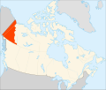
English: Yukon Territory within Canada.
Español: Territorio de Yukón en Canadá.
Date
Source Based on Image:Canada (geolocalisation).svg
Author EOZyo

Licensing

[edit]
Public domain I, the copyright holder of this work, release this work into the public domain. This applies worldwide.
In some countries this may not be legally possible; if so:
I grant anyone the right to use this work for any purpose, without any conditions, unless such conditions are required by law.

File history


Click on a date/time to view the file as it appeared at that time.
Date/TimeThumbnailDimensionsUserComment
current06:46, 29 September 2008Thumbnail for version as of 06:46, 29 September 20081,084 × 920 (93 KB)EOZyo (talk | contribs){{Information |Description={{en|1=Yukon Territory within Canada.}} {{es|1=Territorio de Yukón en Canadá.}} |Source=Based on Image:Canada (geolocalisation).svg |Author=EOZyo |Date=2008-09-29 |Permission= |other_versions= }} <!--{{Ima


You cannot overwrite this file.


The following 2 pages use this file:

Canada

File:Yukon Territory-map.png


File usage on other wikis


The following other wikis use this file:

Usage on af.wikipedia.org

Provinsies en gebiede van Kanada

Yukon


Usage on arc.wikipedia.org

ܝܘܩܘܢ


Usage on ar.wikipedia.org

بوابة:كندا/مقاطعات كندا

بوابة:كندا/مقاطعات كندا/11


Usage on av.wikipedia.org

Гвичинал


Usage on bxr.wikipedia.org

Юкон


Usage on da.wikipedia.org

Yukon

Nahanni Nationalpark

Glacier National Park (Canada)

Skabelon:Nationalparker i Canada

Gulf Islands National Park

Gwaii Haanas

Kootenay National Park

Mount Revelstoke National Park

Pacific Rim National Park Reserve

Yoho National Park

Banff National Park

Elk Islands National Park

Jasper National Park

Waterton Lakes National Park

Wood Buffalo National Park

Grasslands National Park

Prince Albert National Park

Riding Mountain National Park

Wapusk National Park

Bruce Peninsula National Park

Fathom Five National Marine Park

Georgian Bay Islands National Park

Point Pelee National Park

Pukaskwa National Park

Thousand Islands National Park

Forillon National Park

La Mauricie National Park

Mingan Archipelago National Park Reserve

SaguenaySt. Lawrence Marine Park

Fundy National Park

Kouchibouguac National Park

Prince Edward Island National Park

Cape Breton Highlands National Park

Kejimkujik National Park

Gros Morne National Park

Terra Nova National Park

Torngat Mountains National Park

Ivvavik National Park

Kluane National Park

Vuntut National Park

Aulavik National Park

Pingo National Landmark

Tuktut Nogait National Park


View more global usage of this file.

Structured data

Items portrayed in this file

depicts

creator

some value

URL: https://commons.wikimedia.org/wiki/user:EOZyo
Wikimedia username: EOZyo
author name string: EOZyo

copyright status

copyrighted, dedicated to the public domain by copyright holder

copyright license

released into the public domain by the copyright holder

inception

29 September 2008


Retrieved from "https://commons.wikimedia.org/w/index.php?title=File:Yukon,_Canada.svg&oldid=452307478"

Categories: 
SVG maps of Canada
SVG locator maps of provinces of Canada (orange location map scheme)
Hidden categories: 
Self-published work
PD-self


Navigation menu


Personal tools  


English
Not logged in
Talk
Contributions
Create account
Log in


Namespaces  


File
Discussion