タハール州
アフガニスタンの州
タハール州︵タハールしゅう、ペルシア語: د تخار ولايت[5]︶は、アフガニスタン北東部の州である。面積は1万2458平方キロメートル︵34州中19位︶[2]、総人口は約93万人︵34州中9位︶[2]、人口密度は75人/平方キロ︵34州中12位︶である[2]。州都はタールカーン。
タハール州 تخار | |
|---|---|
 | |
| 北緯36度40分 東経69度45分 / 北緯36.667度 東経69.750度座標: 北緯36度40分 東経69度45分 / 北緯36.667度 東経69.750度 | |
| 国 |
|
| 州都 | タールカーン |
| 政府 | |
| • 州知事 | アブドゥル・ラティフ・イブラヒミ |
| 面積 | |
| • 合計 | 12,457.8 km2 |
| 標高 | 790 m |
| 人口 (2012)[2] | |
| • 合計 | 933,700人 |
| • 密度 | 75人/km2 |
| 等時帯 | UTC+4:30 |
| ISO 3166コード | AF-TAK |
| 座標は[4] | |
地理
編集クワジャムハンマッド山脈(英語: Khwaja Muhammad Range/Koh-i- Khwāja Muhammad)の西側に位置している。
-
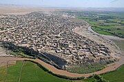
 州都タールカーン
 -
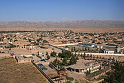
 Khawajah Bahawuddin
 -
 Khawajah Bahawuddin
 -
 Khawajah Bahawuddin
 -
 紀元前1世紀のアイハヌムの哲学者像


歴史
編集青銅器時代・古代
編集
古代のインダス文明はメソポアミア・ハラッパー路を通じて、金などの貴金属や木材をメソポタミア文明に輸出していた。ガンダーラの首都はパキスタンのタキシラにあり、ジャララバードからクナール川沿いの渓谷をチトラルまで登ってバダフシャーン州のコクチャ川に至り、川沿いの渓谷を下ってタハール州に入りパンジ川に達する古道は、ヒンドゥークシュ山脈を越えてアムダリヤ川に達する重要な街道の1つだった[7]。パンジ川に面する州の北部には前21世紀頃にショルトゥガイがあり、前4世紀頃にはアイ・ハヌムがあった。
中世
編集
13世紀後半、中国に向かう途中のマルコ・ポーロがタールカーンを訪れた。その頃のタールカーンは塔里干と呼ばれており、穀物やスモモ︵ハダンキョウ︶、ピスタチオ︵フスダシウ︶の集積地だった。町の南には塩で出来た山があり、品質の良い岩塩が採れたので遠方から商人が集まったと言う[8]。
冷戦時代
編集タハール州は1950年頃には無かったが、1958年から1964年頃にタールカーン州が出来て、1964年4月に改名されて現在の名前になった[9]。
冷戦終結後
編集
タハール州はイスラム協会︵後に北部同盟︶の幹部ブルハーヌッディーン・ラッバーニーやアフマド・シャー・マスードの出身地に隣接しており、イスラム協会の拠点の1つだった。しかし1997年から1998年にかけて、ターリバーンは近隣のクンドゥーズ州やバルフ州、バグラーン州の州都を次々と占領し[10]、反タリバーン勢力は劣勢に立たされた。1998年の2月と5月にはマグニチュード5.8とマグニチュード6.6の地震が発生し、バダフシャーン州やタハール州を中心に数千人の住民が死亡した[11]。
アメリカ同時多発テロ事件以降
編集
2001年9月、アメリカ同時多発テロ事件が起き、10月にはアメリカ合衆国がアフガニスタンに侵攻した。アメリカや有志連合、北部同盟の軍隊はクンドゥーズ包囲戦を行い、11月11日にターリバーンから州都タールカーンを奪回した。2002年3月、アフガニスタン北部地震︵[[マグニチュード#モーメントマグニチュードMw|Mw]]7.4︶が発生し、バダフシャーン州やタハール州で300戸の住宅が被害を被った[12]。2004年10月、第一回の大統領選挙が実施され、タハール州ではラシッド・ドスタムが最多得票︵約40%︶を得た[13]。
第二回大統領選挙後
編集
2009年8月、第二回の大統領選挙が実施され、タハール州ではアブドラ・アブドラ元外相が最多得票︵約52%︶を得た[14]。2010年10月、クンドゥーズ州のムハンマド・オマル知事がタハール州で自爆テロに巻き込まれて死亡した[15]。2012年12月、ISAF軍はタハール州の治安権限をアフガニスタン軍に移譲した[16]。
第三回大統領選挙後
編集
2014年4月、第三回の大統領選挙が実施され、タハール州ではアブドラ・アブドラ元外相が最多得票︵約50%︶を得た[17]。2015年9月、ターリバーンによると南部のIshkamish郡[18]とYangi Qala郡[19]や北部のBangi 郡[20]を攻撃しているようである。2015年10月、バダフシャーン州でマグニチュード7.5の地震が起き、州都タールカーンではメルカリ震度階級VIIの揺れを観測し、将棋倒しなどにより死傷者が出た[21]。同月、ターリバーンはDarqand郡を占領した[22]。
第四回大統領選挙後
編集行政区分
編集
1市16郡を擁する[2]。
- Baharak District
- en:Bangi District
- en:Chah Ab District
- en:Chal District
- en:Darqad District
- en:Dashti Qala District
- en:Farkhar District
- en:Hazar Sumuch District
- en:Ishkamish District
- en:Kalafgan District
- en:Khwaja Baha Wuddin District
- en:Khwaja Ghar District
- en:Namak Ab District
- en:Rustaq District
- en:Taluqan District - 州都タールカーン
- en:Warsaj District
- en:Yangi Qala District
都市
編集
タハール州では州都周辺︵約22万人︶やRustaq郡︵約16万人︶、Chahab郡︵約8万人︶、Khwaja Ghar郡︵約7万人︶など州の北部に多くの住民が居る。人口1万人以上の都市は州都タールカーン︵約7万人︶やChahab︵約2万人︶、Rustaq︵約1万人︶である[26]。
産業
編集農業
編集| 種類 | 生産量 | 順位 |
|---|---|---|
| 小麦 | 43万9000トン | 1位 |
| 米 | 5万6877トン | 3位 |
| 大麦 | 3万7656トン | 3位 |
| とうもろこし | 9702トン | 13位 |
| 綿花 | 3190トン | 4位 |
| アーモンド | 570トン | 6位 |
| グレープフルーツ | 222トン | 16位 |
| 桃 | 110トン | 5位 |
| ザクロ | 100トン | 8位 |
| りんご | 65トン | 19位 |
タハール州は小麦︵34州中1位︶や米︵34州中3位︶、大麦︵34州中3位︶、綿花︵34州中4位︶、桃︵34州中5位︶の生産が全国的に見ても盛んで[27]、アーモンド︵34州中6位︶やザクロ︵34州中8位︶がかなり生産されている[27]。
鉱業
編集住民
編集民族
編集タハール州で人口が最も多いのはウズベク人とタジク人であり、パシュトゥーン人、ハザーラ人が続く[29]。識字率は16%である[29]。
脚注
編集
(一)^ “Afghan Biographies - Ibrahimi, Abdul Latif Ebrahimi”. Afghanistan Online. 2014年2月26日閲覧。
(二)^ abcdef“Area and Administrative and Population”. Islamic Republic of Afghanistan (2013年). 2014年1月17日時点のオリジナルよりアーカイブ。2014年2月3日閲覧。
(三)^ “Topological Information About Places On The Earth”. topocoding.com. 2014年3月9日閲覧。
(四)^ “The U.S. Board on Geographic Name”. U.S. Department of the Interior. 2014年2月14日閲覧。
(五)^ ペルシア語ラテン翻字: Takhār
(六)^ ﹁シルクロードの古代都市﹂P29の地図を参考に作成
(七)^ 加藤九祚﹃シルクロードの古代都市﹄岩波書店、2013年、29-31頁。ISBN 978-4004314448。
(八)^ マルコ・ポーロ、愛宕 松男﹃完訳 東方見聞録1﹄平凡社、2000年、148-151頁。ISBN 978-4582763263。
(九)^ "Provinces of Afghanistan". Statoids. 2014年4月3日閲覧。
(十)^ 高橋 博史 (1998年). “タリバーンによるマザリシャリフの攻略―ドストム将軍の凋落 1998年のアフガニスタン”. 日本貿易振興機構(ジェトロ) アジア経済研究所. 2014年2月20日閲覧。
(11)^ “Historic Earthquakes Magnitude 6.6 Afghanistan-Tajikistan Border Region 1998 May 30 06:22:28 UTC”. USGS Earthquake Hazards Program. 2014年4月7日閲覧。
(12)^ “Historic Earthquakes Magnitude 7.4 HINDU KUSH REGION, AFGHANISTAN 2002 March 03 12:08:19 UTC”. USGS Earthquake Hazards Program. 2014年4月7日閲覧。
(13)^ “Takhar Province”. Independent Election Commission of Afghanistan. 2014年3月10日閲覧。
(14)^ “Takhar Province”. Independent Election Commission of Afghanistan. 2014年2月17日閲覧。
(15)^ “Head of Afghanistan's Kunduz province killed in bombing”. BBC NEWS (2010年10月8日). 2014年2月17日閲覧。
(16)^ “アフガニスタン‥治安情勢”. 外務省. 2014年2月6日閲覧。
(17)^ “2014 Elections Results”. Independent Election Commission of Afghanistan. 2015年2月24日閲覧。
(18)^ “Ishkamish district conquered in country’s north”. アフガニスタン・イスラム首長国︵タリバン︶ (2015年9月28日). 2015年10月27日閲覧。
(19)^ “Yangi Qala district liberated”. アフガニスタン・イスラム首長国︵タリバン︶ (2015年9月29日). 2015年10月27日閲覧。
(20)^ “Mujahideen take control of another district in Takhar”. アフガニスタン・イスラム首長国︵タリバン︶ (2015年9月29日). 2015年10月27日閲覧。
(21)^ アフガニスタン北部の地震 死者100人超に ︵NHKニュース 2015年10月26日21時01分︶
(22)^ Mirwais Harooni、James Mackenzie、Robert Birsel (2015年10月28日). “Taliban overrun district in quake-hit northern Afghanistan”. reuters. 2015年10月29日閲覧。
(23)^ “Clashes Reach Gates of Faryab's Capital in Northern Afghanistan” (英語). TOLOnews. 2021年8月9日閲覧。
(24)^ ﹁北部3州の州都を占領、タリバンの進攻続く アフガニスタン﹂﹃BBCニュース﹄。2021年8月9日閲覧。
(25)^ “Fighting Underway in Balkh, Takhar Provinces” (英語). TOLOnews. 2021年8月9日閲覧。
(26)^ Central Statistics Organization (2013年). “Settled Population of Takhar province by Civil Division , Urban, Rural and Sex-2012-13”. Islamic Republic of Afghanistan. 2014年2月8日閲覧。
(27)^ abc“Agriculture Development”. Islamic Republic of Afghanistan (2013年). 2014年1月17日時点のオリジナルよりアーカイブ。2014年2月5日閲覧。
(28)^ Ministry of Mines and Petroleum (2011年10月2日). “New Information Management System for Ministry of Mines, Afghanistan”. Islamic Republic of Afghanistan. 2014年2月10日閲覧。
(29)^ abMinistry of Rural Rehabilitation and Development (2013年). “Takhar Provincial Profile”. Islamic Republic of Afghanistan. 2014年4月5日閲覧。
関連項目
編集この項目は、アフガニスタンに関連した書きかけの項目です。この項目を加筆・訂正などしてくださる協力者を求めています(Pアジア / PJ南アジア)。 |