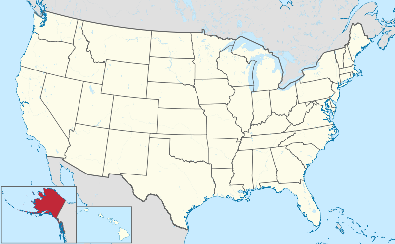
File:Alaska in United States.svg


From Wikimedia Commons, the free media repository


Jump to navigation  Jump to search  
File

File history

File usage on Commons

File usage on other wikis

Metadata
File:Alaska in United States.svg
Size of this PNG preview of this SVG file: 800 × 495 pixels. Other resolutions: 320 × 198 pixels | 640 × 396 pixels | 1,024 × 634 pixels | 1,280 × 792 pixels | 2,560 × 1,585 pixels | 1,181 × 731 pixels.

Original file(SVG file, nominally 1,181 × 731 pixels, file size: 1.86 MB)

File information
Structured data

Captions

Captions


Add a one-line explanation of what this file represents

Summary

[edit]
Description
Deutsch: Lage von Alaska in den Vereinigten Staaten.
English: Location of state of Alaska in the United States
Date
Source Own work
 
This SVG map includes elements from this map:
Usa edcp location map.svg (by Uwe Dedering).
 
This SVG map includes elements from this map:
USA Hawaii location map.svg (by NordNordWest).
 
This SVG map includes elements from this map:
Canada location map.svg (by Yug).
Author TUBS Gallery
Other versions

This SVG map is part of a locator map series applying the widespread location map scheme. Please see root category to browse for more.

SVG development

InfoField

 
The SVG code is valid.
 
This locator map was created with Adobe IllustratorbyPalosirkka.
 
This SVG locator map was uploaded with Commonist.

Licensing

[edit]
I, the copyright holder of this work, hereby publish it under the following license:
w:en:Creative Commons
attribution share alike
This file is licensed under the Creative Commons Attribution-Share Alike 3.0 Unported license.
You are free:
  • to share – to copy, distribute and transmit the work
  • to remix – to adapt the work
  • Under the following conditions:
    I'd greatly appreciate, that you attribute this media file to Wikimedia Commons, if used outside Wikipedia or Commons. For use in publications such as books, newspapers, blogs, websites, please insert here the following line:
    {{published|author= |date= |url= |title= |org= }}
    and fill the applicable fields. (Example). License terms given above still apply.

    বাংলা  Deutsch  Deutsch (Sie-Form)  Ελληνικά  English  español  français  Ἀρχαία ἑλληνικὴ  Bahasa Indonesia  日本語  македонски  Nederlands  português  русский  Türkçe  简体中文  繁體中文  +/−

    File history


    Click on a date/time to view the file as it appeared at that time.
    Date/TimeThumbnailDimensionsUserComment
    current12:33, 12 September 2012Thumbnail for version as of 12:33, 12 September 20121,181 × 731 (1.86 MB)Palosirkka (talk | contribs)Scrubbed with http://codedread.com/scour/
    15:47, 30 July 2011Thumbnail for version as of 15:47, 30 July 20111,181 × 731 (3.46 MB)TUBS (talk | contribs)


    You cannot overwrite this file.


    More than 100 pages use this file. The following list shows the first 100 pages that use this file only. A full list is available.

    User:Yug

    File:Lage des Alb-Donau-Kreises in Deutschland.png

    File:Lage des Bodenseekreises in Deutschland.png

    File:Lage des Landkreises Biberach in Deutschland.png

    File:Lage des Landkreises Loerrach in Deutschland.png

    File:Locator map AC (city) in Germany.svg

    File:Locator map AC (district) in Germany.svg

    File:Locator map AC (region) in Germany.svg

    File:Locator map BGL in Bavaria.svg

    File:Locator map BI in Germany.svg

    File:Locator map BM in Germany.svg

    File:Locator map BN in Germany.svg

    File:Locator map BOR in Germany.svg

    File:Locator map BOT in Germany.svg

    File:Locator map BO in Germany.svg

    File:Locator map Baden-Württemberg in Germany.svg

    File:Locator map Bavaria in Germany.svg

    File:Locator map Berlin in Germany.svg

    File:Locator map Brandenburg in Germany.svg

    File:Locator map Bremen in Germany.svg

    File:Locator map COE in Germany.svg

    File:Locator map DN in Germany.svg

    File:Locator map DO in Germany.svg

    File:Locator map DU in Germany.svg

    File:Locator map D in Germany.svg

    File:Locator map EN in Germany.svg

    File:Locator map EU in Germany.svg

    File:Locator map E in Germany.svg

    File:Locator map FN in Baden-Württemberg.svg

    File:Locator map GE in Germany.svg

    File:Locator map GL in Germany.svg

    File:Locator map GM in Germany.svg

    File:Locator map GT in Germany.svg

    File:Locator map HAM in Germany.svg

    File:Locator map HA in Germany.svg

    File:Locator map HB (Bremen) in Germany.svg

    File:Locator map HER in Germany.svg

    File:Locator map HF in Germany.svg

    File:Locator map HSK in Germany.svg

    File:Locator map HS in Germany.svg

    File:Locator map HX in Germany.svg

    File:Locator map Hamburg in Germany.svg

    File:Locator map Hesse in Germany.svg

    File:Locator map KLE in Germany.svg

    File:Locator map KR in Germany.svg

    File:Locator map KS in Germany.svg

    File:Locator map K in Germany.svg

    File:Locator map LEV in Germany.svg

    File:Locator map LIP in Germany.svg

    File:Locator map LVR in Germany.svg

    File:Locator map LWL in Germany.svg

    File:Locator map Lower-Saxony in Germany.svg

    File:Locator map ME in Germany.svg

    File:Locator map MG in Germany.svg

    File:Locator map MH in Germany.svg

    File:Locator map MI in Germany.svg

    File:Locator map MK in Germany.svg

    File:Locator map MS in Germany.svg

    File:Locator map Mecklenburg-Vorpommern in Germany.svg

    File:Locator map NE in Germany.svg

    File:Locator map North Rhine-Westphalia in Germany.svg

    File:Locator map OB in Germany.svg

    File:Locator map OE in Germany.svg

    File:Locator map OS in Germany.svg

    File:Locator map PB in Germany.svg

    File:Locator map RB AR in Germany.svg

    File:Locator map RB DT in Germany.svg

    File:Locator map RB D in Germany.svg

    File:Locator map RB K in Germany.svg

    File:Locator map RB MS in Germany.svg

    File:Locator map RE in Germany.svg

    File:Locator map RS in Germany.svg

    File:Locator map RVR in Germany.svg

    File:Locator map Rhineland-Palatinate in Germany.svg

    File:Locator map SG in Germany.svg

    File:Locator map SI in Germany.svg

    File:Locator map SLS in Saarland.svg

    File:Locator map SO in Germany.svg

    File:Locator map ST in Germany.svg

    File:Locator map SU in Germany.svg

    File:Locator map Saarland in Germany.svg

    File:Locator map Saxony-Anhalt in Germany.svg

    File:Locator map Saxony in Germany.svg

    File:Locator map Schleswig-Holstein in Germany.svg

    File:Locator map Thuringia in Germany.svg

    File:Locator map UN in Germany.svg

    File:Locator map VIE in Germany.svg

    File:Locator map WAF in Germany.svg

    File:Locator map WES in Germany.svg

    File:Locator map WIL in Rhineland-Palatinate.svg

    File:Locator map W in Germany.svg

    File:Municipio 1 in Milan.svg

    File:Municipio 2 in Milan.svg

    File:Municipio 3 in Milan.svg

    File:Municipio 4 in Milan.svg

    File:Municipio 5 in Milan.svg

    File:Municipio 6 in Milan.svg

    File:Municipio 7 in Milan.svg

    File:Municipio 8 in Milan.svg

    File:Municipio 9 in Milan.svg


    View more links to this file.

    File usage on other wikis


    The following other wikis use this file:

    Usage on bs.wikipedia.org

    Kategorija:Aljaska


    Usage on cs.wikipedia.org

    Seznam vlajek států Spojených států amerických

    Seznam státních fosílií amerických států

    Seznam státních písní států USA


    Usage on cy.wikipedia.org

    Alaska

    Bethel Census Area, Alaska

    Bristol Bay Borough, Alaska

    Aleutians East Borough, Alaska

    Aleutians West Census Area, Alaska

    Denali Borough, Alaska

    Dillingham Census Area, Alaska

    Fairbanks North Star Borough, Alaska

    Haines Borough, Alaska

    Kenai Peninsula Borough, Alaska

    Ketchikan Gateway Borough, Alaska

    Kodiak Island Borough, Alaska

    Kusilvak Census Area, Alaska

    Lake and Peninsula Borough, Alaska

    Matanuska-Susitna Borough, Alaska

    Nome Census Area, Alaska

    North Slope Borough, Alaska

    Northwest Arctic Borough, Alaska

    Petersburg Borough, Alaska

    Skagway, Alaska

    Southeast Fairbanks Census Area, Alaska

    Unorganized Borough, Alaska

    ValdezCordova Census Area, Alaska

    Wrangell, Alaska

    Yakutat, Alaska


    Usage on da.wikipedia.org

    Bruger:Gorbi/Kladde1a


    Usage on en.wikipedia.org

    United States presidential elections in Alaska

    User:Kavyansh.Singh/sandbox4


    Usage on en.wikibooks.org

    Wikijunior:North America/United States/Alaska


    Usage on es.wikipedia.org

    Levelock (Alaska)

    Distrito congresional at-large de Alaska


    Usage on fr.wikinews.org

    Élection présidentielle américaine de 2016 : Alaska


    Usage on got.wikipedia.org

    𐌰𐌻𐌰𐍃𐌺𐌰


    Usage on haw.wikipedia.org

    ʻĀlaka


    Usage on incubator.wikimedia.org

    Wp/grc/λάσκα

    Wp/ryu/

    Wp/cpx/Alaska

    Wp/grc/Πολιτεαι κα κτήσεις τν νωμένων Πολιτειν τς μερικς


    Usage on ja.wikipedia.org


    Usage on lb.wikipedia.org

    Alaska


    Usage on lld.wikipedia.org

    Alaska


    Usage on ml.wikipedia.org

    ി 


    Usage on nl.wikipedia.org

    Lijst van vlaggen van Amerikaanse deelgebieden

    Unalaska

    Utqiaġvik

    Point Barrow


    View more global usage of this file.

    Metadata

    This file contains additional information such as Exif metadata which may have been added by the digital camera, scanner, or software program used to create or digitize it. If the file has been modified from its original state, some details such as the timestamp may not fully reflect those of the original file. The timestamp is only as accurate as the clock in the camera, and it may be completely wrong.

    Structured data

    Items portrayed in this file

    depicts

    copyright status

    copyrighted

    copyright license

    Creative Commons Attribution-ShareAlike 3.0 Unported

    inception

    30 July 2011

    source of file

    original creation by uploader

    media type

    image/svg+xml

    checksum

    3e9a0b567b0469a861f188835d468f14e2ec4bc4

    determination method: SHA-1

    data size

    1,947,383 byte

    height

    731 pixel

    width

    1,181 pixel


    Retrieved from "https://commons.wikimedia.org/w/index.php?title=File:Alaska_in_United_States.svg&oldid=787762440"

    Categories: 
    SVG locator maps of Alaska (location map scheme)
    SVG locator maps of states in the United States (location map scheme)
    Hidden categories: 
    Attributed work
    SVG locator maps (location map scheme) (all)
    Valid SVG created with Adobe Illustrator:Locator maps
    Uploaded with Commonist
    CC-BY-SA-3.0
    Self-published work


    Navigation menu


    Personal tools  


    English
    Not logged in
    Talk
    Contributions
    Create account
    Log in


    Namespaces  


    File
    Discussion