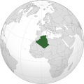
File:Algeria (orthographic projection).svg


From Wikimedia Commons, the free media repository


Jump to navigation  Jump to search  
File

File history

File usage on Commons

File usage on other wikis

Metadata
File:Algeria (orthographic projection).svg
Size of this PNG preview of this SVG file: 550 × 550 pixels. Other resolutions: 240 × 240 pixels | 480 × 480 pixels | 768 × 768 pixels | 1,024 × 1,024 pixels | 2,048 × 2,048 pixels.

Original file(SVG file, nominally 550 × 550 pixels, file size: 218 KB)

File information
Structured data

Captions

Captions


Add a one-line explanation of what this file represents

Summary

[edit]
Description
العربية: الخريطة الهجائية للجزائر.
English: Orthographic map of Algeria.
Español: Mapa ortográfico de Argelia.
Română: Harta ortogonală a Algeriei.
Source Own work
Author L'Américain

Licensing

[edit]
Public domain I, the copyright holder of this work, release this work into the public domain. This applies worldwide.
In some countries this may not be legally possible; if so:
I grant anyone the right to use this work for any purpose, without any conditions, unless such conditions are required by law.

File history


Click on a date/time to view the file as it appeared at that time.
(newest | oldest) View (newer 10 | ) (10 | 20| 50| 100 | 250 | 500)
Date/TimeThumbnailDimensionsUserComment
current17:22, 27 December 2022Thumbnail for version as of 17:22, 27 December 2022550 × 550 (218 KB)M.Bitton (talk | contribs)Reverted to version as of 13:25, 1 March 2021 (UTC): per COM:OVERWRITE + a centered version already exists
14:41, 24 December 2022Thumbnail for version as of 14:41, 24 December 20222,048 × 2,048 (1.25 MB)Takiva (talk | contribs).
13:25, 1 March 2021Thumbnail for version as of 13:25, 1 March 2021550 × 550 (218 KB)Trần Nguyễn Minh Huy (talk | contribs)Reverted to version as of 13:22, 2 April 2013 (UTC) missing South Sudan
07:31, 28 February 2021Thumbnail for version as of 07:31, 28 February 2021550 × 550 (281 KB)Trần Nguyễn Minh Huy (talk | contribs)fix scheme
13:22, 2 April 2013Thumbnail for version as of 13:22, 2 April 2013550 × 550 (218 KB)Chipmunkdavis (talk | contribs)Fixing Moldova, Lebanon, Israel, deleting extra layer of borders
20:47, 3 February 2013Thumbnail for version as of 20:47, 3 February 2013550 × 550 (186 KB)Chipmunkdavis (talk | contribs)Removing solid fill from the borders so the lakes can be seen
04:31, 7 April 2012Thumbnail for version as of 04:31, 7 April 2012550 × 550 (186 KB)Chipmunkdavis (talk | contribs)Egyptian and Kenyan administrative borders
16:10, 14 September 2011Thumbnail for version as of 16:10, 14 September 2011550 × 550 (186 KB)Chipmunkdavis (talk | contribs)Centreing
11:08, 12 July 2011Thumbnail for version as of 11:08, 12 July 2011550 × 550 (187 KB)Marquinhos (talk | contribs)Added border Sudan-South Sudan.
13:13, 3 January 2011Thumbnail for version as of 13:13, 3 January 2011550 × 550 (281 KB)Martin H. (talk | contribs)Reverted to version as of 22:15, 13 January 2010

(newest | oldest) View (newer 10 | ) (10 | 20| 50| 100 | 250 | 500)


You cannot overwrite this file.


More than 100 pages use this file. The following list shows the first 100 pages that use this file only. A full list is available.

Greygreen orthographic projections maps

User:Heraldry/Projections

User:Ssolbergj/orthographic

File:ALBA (orthographic projection).png

File:Africa (orthographic projection).svg

File:African Union (orthographic projection).svg

File:Almoravid map.svg

File:America do Sul (orthographic projection).jpg

File:Americas (orthographic projection).svg

File:Andean Community (orthographic projection).svg

File:Antarctica (orthographic projection).svg

File:Antillas (orthographic projection).svg

File:Arctic (orthographic projection).svg

File:Argelia (orthographic projection).svg

File:Argentina (orthographic projection).png

File:Argentina (orthographic projection).svg

File:Aridoamerica (orthographic projection).svg

File:Armenia (orthographic projection).svg

File:Asia (orthographic projection).svg

File:Association of Southeast Asian Nations (orthographic projection).svg

File:Australia-New Guinea (orthographic projection).svg

File:Australia (orthographic projection).svg

File:Australia map with outlying islands.svg

File:Bhutan (orthographic projection).svg

File:Brazil (orthographic projection).svg

File:CECAFA-Map.svg

File:Canada (orthographic projection).svg

File:Cape Verde (orthographic projection).svg

File:Captaincy General of Chile (orthographic projection).svg

File:Central America (orthographic projection).svg

File:Central Asia (orthographic projection).svg

File:Chile (orthographic projection).svg

File:Colombia (orthographic projection).svg

File:Democratic Republic of the Congo (orthographic projection).svg

File:Dominion of Pakistan & Indian Controlled Kashmir (orthographic projection).svg

File:East Asia (orthographic projection).svg

File:Ecuador (orthographic projection).svg

File:Europe (orthographic projection).svg

File:European Union (orthographic projection).svg

File:Federal Republic of Central America (orthographic projection).svg

File:First Brazilian Empire (orthographic projection).svg

File:First Mexican Empire (orthographic projection).svg

File:Georgia (orthographic projection).svg

File:Germany (orthographic projection).svg

File:Global European Union.svg

File:Great Colombia (orthographic projection).svg

File:Greater Middle East (orthographic projection).svg

File:Haiti (orthographic projection).svg

File:India (orthographic projection).svg

File:Indonesia (orthographic projection).svg

File:Iran (orthographic projection).svg

File:Iraq (orthographic projection).svg

File:Jamaica (orthographic projection).svg

File:Japan (orthographic projection).svg

File:Kazakhstan (orthographic projection).svg

File:Latin America (orthographic projection).svg

File:Lusophone America (orthographic projection).svg

File:MERCOSUR (orthographic projection).svg

File:Madagascar (orthographic projection).svg

File:Maghreb (orthographic projection).svg

File:Malaysia (orthographic projection).svg

File:Mayan languages (orthographic projection).svg

File:Mesoamerica (orthographic projection) with borders.svg

File:Mexico (orthographic projection).svg

File:Mexico and Central America (orthographic projection).svg

File:Middle East (orthographic projection).svg

File:Mongolia (orthographic projection).svg

File:New Spain (orthographic projection).svg

File:New Zealand (orthographic projection).svg

File:Nigeria (orthographic projection).svg

File:North Africa (orthographic projection).svg

File:North America (orthographic projection).svg

File:North American Agreement (orthographic projection).svg

File:North Korea (orthographic projection).svg

File:Papua New Guinea (orthographic projection).svg

File:Paraguay (orthographic projection).svg

File:People's Republic of China (orthographic projection).svg

File:Peru (orthographic projection).svg

File:PeruBolivia Confederation (orthographic projection).svg

File:Philippines (orthographic projection).svg

File:Republic of Artsakh (orthographic projection).svg

File:Republic of China (orthographic projection).svg

File:Rio Group (orthographic projection).svg

File:Roman Empire (orthographic projection).svg

File:Russian Federation (orthographic projection).svg

File:Second Mexican Empire (orthographic projection).svg

File:South Asia (orthographic projection) without national boundaries.svg

File:South Korea (orthographic projection).svg

File:Southern Europe (orthographic projection).svg

File:Tawantinsuyu (orthographic projection).svg

File:The Philippines and ASEAN (orthographic projection).svg

File:Third Reich (orthographic projection).svg

File:Tunisia (orthographic projection).svg

File:Turkey (orthographic projection).svg

File:Union of South American Nations (orthographic projection).svg

File:Union of Soviet Socialist Republics (orthographic projection).svg

File:United Provinces of Central America (orthographic projection).svg

File:Venezuela (orthographic projection).svg

File:Viceroyalty of Peru (orthographic projection).svg

File:Viceroyalty of the Río de la Plata (orthographic projection).svg


View more links to this file.

File usage on other wikis


The following other wikis use this file:

Usage on ace.wikipedia.org

Aljazair

Seunaleuëk:Infobox Aljazair


Usage on af.wikipedia.org

Kategorie:Algerië


Usage on ami.wikipedia.org

Algeria


Usage on ar.wikipedia.org

بوابة:العالم الإسلامي/دولة مختارة/أرشيف

بوابة:العالم الإسلامي/دولة مختارة/40

قائمة الصراعات في الجزائر

آثار الجزائر

التركيبة السكانية في الجزائر


Usage on avk.wikipedia.org

Jazaira


Usage on azb.wikipedia.org

الجزاییر


Usage on az.wiktionary.org

Əlcəzair


Usage on bg.wikipedia.org

Алжир


Usage on bh.wikipedia.org

ि


Usage on bi.wikipedia.org

Aljiria


Usage on bn.wikipedia.org

ি


Usage on btm.wikipedia.org

Aljasair


Usage on bug.wikipedia.org


Usage on ca.wikipedia.org

Dones a Algèria


Usage on cbk-zam.wikipedia.org

Argelia


Usage on cdo.wikipedia.org

Algeria


Usage on ceb.wikipedia.org

Arhelya


Usage on chr.wikipedia.org


Usage on cs.wikipedia.org

Alžírsko

Seznam největších říší světa


Usage on dag.wikipedia.org

Kompini nima din be Algeria


Usage on da.wikipedia.org

Algeriet


Usage on da.wiktionary.org

Algeriet


Usage on en.wikipedia.org

Archaeology of Algeria

Demographics of Algeria

List of companies of Algeria

Women in Algeria

List of conflicts in Algeria

User:Lazz R/CountryGuide


Usage on en.wikinews.org

Category:Algeria


Usage on en.wiktionary.org

Algeria


Usage on es.wikipedia.org

Argelia

Wikiproyecto:Ilustración/Taller de Cartografía/Realizaciones/Mapas ortográficos/África


Usage on fr.wikipedia.org

Minorités sexuelles et de genre en Algérie

Utilisateur:Indif/Noms des lieux de naissance (Algérie ou Algérie française ?)


Usage on gcr.wikipedia.org

Laljéri


Usage on gu.wikipedia.org

િ


Usage on gv.wikipedia.org

Yn Algear


Usage on hak.wikipedia.org

Algeria


Usage on hi.wikipedia.org

ि


Usage on hr.wikipedia.org

Suradnica:Svefnleysi/predlošci


Usage on hy.wikipedia.org

Ալժիրի բնակչություն


Usage on id.wikipedia.org

Aljazair

Templat:Aljazair infobox

Yahudi-Aljazair


View more global usage of this file.

Metadata

This file contains additional information such as Exif metadata which may have been added by the digital camera, scanner, or software program used to create or digitize it. If the file has been modified from its original state, some details such as the timestamp may not fully reflect those of the original file. The timestamp is only as accurate as the clock in the camera, and it may be completely wrong.

Structured data

Items portrayed in this file

depicts

creator

some value

URL: https://commons.wikimedia.org/wiki/user:L%27Am%C3%A9ricain
Wikimedia username: L'Américain
author name string: L'Américain

copyright status

copyrighted, dedicated to the public domain by copyright holder

copyright license

released into the public domain by the copyright holder

source of file

original creation by uploader

media type

image/svg+xml

checksum

2c796a9213b04c45d4a8aeacb6bc7c0ec3c473e7

determination method: SHA-1

data size

222,739 byte

height

550 pixel

width

550 pixel


Retrieved from "https://commons.wikimedia.org/w/index.php?title=File:Algeria_(orthographic_projection).svg&oldid=808975471"

Categories: 
SVG locator maps of Algeria (gray and green globe scheme)
Locator maps of Algeria
Hidden categories: 
Self-published work
PD-self


Navigation menu


Personal tools  


English
Not logged in
Talk
Contributions
Create account
Log in


Namespaces  


File
Discussion