File:BlankMap-World-Microstates.svg


From Wikimedia Commons, the free media repository


Jump to navigation  Jump to search  
File

File history

File usage on Commons

File usage on other wikis

Metadata
File:BlankMap-World-Microstates.svg
Size of this PNG preview of this SVG file: 800 × 406 pixels. Other resolutions: 320 × 162 pixels | 640 × 325 pixels | 1,024 × 520 pixels | 1,280 × 650 pixels | 2,560 × 1,300 pixels | 2,754 × 1,398 pixels.

Original file(SVG file, nominally 2,754 × 1,398 pixels, file size: 1.09 MB)

File information
Structured data

Captions

Captions


Add a one-line explanation of what this file represents

Summary

[edit]
Description
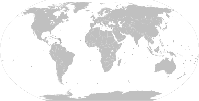
English: This file is File:BlankMap-World.svg with all the circled states and territories now visible. See File talk:BlankMap-World.svg/Documentation#Small countries.

This image shows a global map of the world, with all the countries and dependencies that are under 20,000 km² in area, as well as various other subnational territories, represented by a circle.

Consider using BlankMap-World.svg instead of this image for creating derivative works. Because this is a purely technical illustration (see below), it is not being actively maintained – using the primary map will avoid inadvertently using outdated and/or incorrect information.

This is a purely technical illustration created for the purpose of being used in the documentation (click here) for the main image, from which this file was derived: BlankMap-World.svg. As such, this map is not making any political statements – it simply shows hidden elements in the main image.
Date
Source This file was derived from: BlankMap-World.svg
and is a simple technical illustration of the capabilities of the main file, with all "opacity" elements in SVG being assigned 1.
Author Various
Other versions

Derivative works of this file:

SVG development

InfoField

 
The SVG code is valid.
 
This map was created with Inkscape, and then manually edited
.

Licensing

[edit]
Public domain I, the copyright holder of this work, release this work into the public domain. This applies worldwide.
In some countries this may not be legally possible; if so:
I grant anyone the right to use this work for any purpose, without any conditions, unless such conditions are required by law.

File history


Click on a date/time to view the file as it appeared at that time.
(newest | oldest) View (newer 10 | ) (10 | 20| 50| 100 | 250 | 500)
Date/TimeThumbnailDimensionsUserComment
current10:17, 4 November 2023Thumbnail for version as of 10:17, 4 November 20232,754 × 1,398 (1.09 MB)Siirski (talk | contribs)Reverted to version as of 13:29, 22 April 2023 (UTC)
17:08, 30 September 2023Thumbnail for version as of 17:08, 30 September 20232,754 × 1,398 (1.1 MB)Caawiyahaderon (talk | contribs)Sool under SSC control https://www.thehindu.com/news/international/pro-somalia-militia-takes-key-army-base-in-breakaway-region/article67238670.ece
13:29, 22 April 2023Thumbnail for version as of 13:29, 22 April 20232,754 × 1,398 (1.09 MB)Discombobulates (talk | contribs)Add bv (Bouvet Island), a Norwegian dependency (position of the island based on https://commons.wikimedia.org/wiki/File:Bouvet-pos.png overlayed at 607.5, 668.5 with a width of 1450 and a proportional height of 713.875)
15:14, 15 April 2023Thumbnail for version as of 15:14, 15 April 20232,754 × 1,398 (1.1 MB)Discombobulates (talk | contribs)Add ax (Åland) as a part of fi (Finland)
09:49, 12 July 2022Thumbnail for version as of 09:49, 12 July 20222,754 × 1,398 (1.06 MB)MChinaGA (talk | contribs)Reverted to version as of 00:27, 15 May 2022 (UTC)
09:48, 12 July 2022Thumbnail for version as of 09:48, 12 July 2022512 × 263 (1.09 MB)MChinaGA (talk | contribs)Deleted HK and MO since they are SAR and don't have the right from being based by US.
00:27, 15 May 2022Thumbnail for version as of 00:27, 15 May 20222,754 × 1,398 (1.06 MB)Cherkash (talk | contribs)unnecessary removal of Aral Sea, and it contradicts the purpose of this map
08:29, 1 May 2022Thumbnail for version as of 08:29, 1 May 20222,754 × 1,398 (1.09 MB)Kwamikagami (talk | contribs)rem. Aral Sea, per other intermittant lakes of that size (e.g. Lake Chad)
06:38, 8 July 2019Thumbnail for version as of 06:38, 8 July 20192,754 × 1,398 (1.09 MB)Giorgi Balakhadze (talk | contribs)Reverted to the administrator's version!
16:47, 4 July 2019Thumbnail for version as of 16:47, 4 July 20192,754 × 1,398 (1.06 MB)Cherkash (talk | contribs)synced up with the main blank map (per this image's description)

(newest | oldest) View (newer 10 | ) (10 | 20| 50| 100 | 250 | 500)


You cannot overwrite this file.


The following 43 pages use this file:

User:Alex Great/Favorites

User:Giorgi Balakhadze/Gallery

User:NuclearVacuum

User:Thomson Walt

Commons:Village pump/Archive/2012/06

File:1948 Winter Olympic Games medals map.png

File:1952 Winter Olympic Games medals map.png

File:1956 Winter Olympic Games medals map.png

File:1960 Winter Olympic Games medals map.png

File:1964 Winter Olympic Games medals map.png

File:1968 Winter Olympic Games medals map.png

File:1976 Winter Olympic Games medals map.png

File:1980 Winter Olympic Games medals map.png

File:1988 Winter Olympic Games medals map.png

File:1994 Winter Olympic Games medals map.png

File:1998 Winter Olympic Games medals map.png

File:2002 Winter Olympic Games medals map.png

File:2006 Winter Olympic Games Medals map.svg

File:2010 Winter Olympic Games Medals map.svg

File:2014 Winter Olympic Games Medals map.svg

File:2018 Winter Olympic Games medals map.png

File:2019 King's Cup Sepaktakraw World Championship countries.png

File:AfriMusic Song Contest 2018 map.svg

File:AfriMusic Song Contest 2019 map.svg

File:AfriMusic Song Contest 2020 map.svg

File:AfriMusic participating countries map.svg

File:Copa America Centenario Map.svg

File:Countries with a former and incumbent female head of state-govt.svg

File:Drinking Age - Global.svg

File:Gambling Age - Global.svg

File:Häagen-Dazs Map.svg

File:Intervision 2008 Map.svg

File:Intervision 2015 Map.svg

File:Legal Systems - Global.svg

File:Legal Systems - Global (AR).svg

File:Map of the World (Colombian peace agreement referendum).svg

File:Map of the countries in which the New Year Concert 2019 of the Vienna Philharmonics was distributed via TV.svg

File:NATO cooperations partners.svg

File:Singapore OSA ASA.svg

File:Taco Bell world map.svg

File:Travel of Giorgia Meloni as the prime minister of Italy.svg

File:UK reciprocal health agreements.svg

File:Страны и территории, публикуемые из Народной карты Яндекса.svg


File usage on other wikis


The following other wikis use this file:

Usage on en.wikipedia.org

Wikipedia:Graphics Lab/Map workshop/Archive/Nov 2009

Wikipedia:SVG help/Archive 6


Usage on he.wikipedia.org

ויקיפדיה:סדנה לגרפיקה/ארכיון 48

ויקיפדיה:סדנה לגרפיקה/ארכיון 50


Metadata

This file contains additional information such as Exif metadata which may have been added by the digital camera, scanner, or software program used to create or digitize it. If the file has been modified from its original state, some details such as the timestamp may not fully reflect those of the original file. The timestamp is only as accurate as the clock in the camera, and it may be completely wrong.

Structured data

Items portrayed in this file

depicts

copyright status

copyrighted, dedicated to the public domain by copyright holder

copyright license

released into the public domain by the copyright holder

media type

image/svg+xml

inception

June 2009

checksum

ba34a500cad875bb45aa00dcf8a30ff36d2f64ff

determination method: SHA-1

data size

1,139,707 byte

height

1,398 pixel

width

2,754 pixel


Retrieved from "https://commons.wikimedia.org/w/index.php?title=File:BlankMap-World-Microstates.svg&oldid=869196184"

Categories: 
SVG blank maps of the world with small regions drawn as circles
SVG maps with Robinson projection
Hidden categories: 
Derivative versions
Files with derivative versions
Valid SVG created with Text Editor
Valid SVG created with Inkscape-hand:Maps
Self-published work
PD-self
User:NuclearVacuum/Images


Navigation menu


Personal tools  


English
Not logged in
Talk
Contributions
Create account
Log in


Namespaces  


File
Discussion