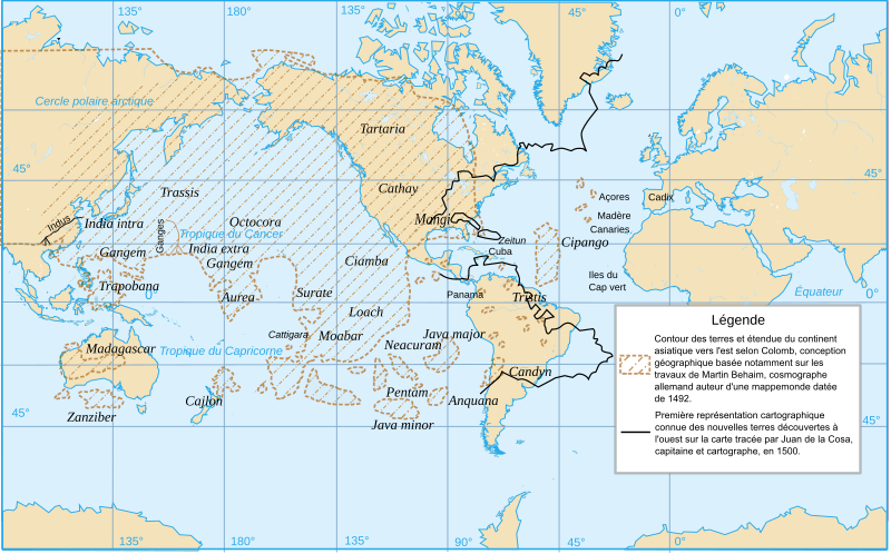
File:Conceptions Colomb map-fr.svg


From Wikimedia Commons, the free media repository


Jump to navigation  Jump to search  
File

File history

File usage on Commons

File usage on other wikis

Metadata
File:Conceptions Colomb map-fr.svg
Size of this PNG preview of this SVG file: 800 × 497 pixels. Other resolutions: 320 × 199 pixels | 640 × 398 pixels | 1,024 × 636 pixels | 1,280 × 795 pixels | 2,560 × 1,591 pixels | 1,022 × 635 pixels.

Original file(SVG file, nominally 1,022 × 635 pixels, file size: 1.01 MB)

File information
Structured data

Captions

Captions


Add a one-line explanation of what this file represents

Summary

[edit]
Description Conceptions cartographiques de Colomb.
Date
Source self-made. Based upon a map published in Jean Amsler, « La Renaissance (1415-1600) », Histoire universelle des explorations, tome II, Nouvelle Librairie de France, 1968, p. 56/57 (encart couleur).
Author Ewan ar Born
SVG development

InfoField

 
The source code of this SVGisinvalid due to 9 errors.
 
This W3C-invalid map was created with Inkscape, or with something else.
Translate this file This SVG file contains embedded text that can be translated into your language, using any capable SVG editor, text editor or the SVG Translate tool. For more information see: About translating SVG files.

--203.220.86.132 03:32, 10 December 2008 (UTC) C'est une issue d'un dessin de navigation pour ce reperer a istambul , comme dans assassin's creed .

Licensing

[edit]
I, the copyright holder of this work, hereby publish it under the following licenses:
GNU head Permission is granted to copy, distribute and/or modify this document under the terms of the GNU Free Documentation License, Version 1.2 or any later version published by the Free Software Foundation; with no Invariant Sections, no Front-Cover Texts, and no Back-Cover Texts. A copy of the license is included in the section entitled GNU Free Documentation License.
w:en:Creative Commons
attribution
This file is licensed under the Creative Commons Attribution 3.0 Unported license.
You are free:
  • to share – to copy, distribute and transmit the work
  • to remix – to adapt the work
  • Under the following conditions:
    You may select the license of your choice.

    File history


    Click on a date/time to view the file as it appeared at that time.
    Date/TimeThumbnailDimensionsUserComment
    current14:52, 14 April 2008Thumbnail for version as of 14:52, 14 April 20081,022 × 635 (1.01 MB)Ewan ar Born (talk | contribs){{Information |Description= Conceptions cartographiques de Colomb. |Source=self-made |Date=14 avril 2008 |Author= Ewan ar Born |Permission= |other_versions= }} {{Atelier graphique carte}} {{Inkscape}} {{Translation possible}} [[Categ


    You cannot overwrite this file.


    The following page uses this file:

    Christopher Columbus


    File usage on other wikis


    The following other wikis use this file:

    Usage on eu.wikipedia.org

    Kristobal Kolon


    Usage on fa.wikipedia.org

    کریستف کلمب

    سفرهای اکتشافی کریستف کلمب


    Usage on fr.wikipedia.org

    Christophe Colomb

    Utilisateur:Ewan ar Born/Graphisme

    Wikipédia:Atelier graphique/Cartes/Archives/avril 2008


    Usage on simple.wikipedia.org

    Christopher Columbus


    Usage on sl.wikipedia.org

    Odkritje Amerike


    Metadata

    This file contains additional information such as Exif metadata which may have been added by the digital camera, scanner, or software program used to create or digitize it. If the file has been modified from its original state, some details such as the timestamp may not fully reflect those of the original file. The timestamp is only as accurate as the clock in the camera, and it may be completely wrong.

    Structured data

    Items portrayed in this file

    depicts

    creator

    some value

    author name string: Ewan ar Born
    URL: https://commons.wikimedia.org/wiki/user:Ewan_ar_Born
    Wikimedia username: Ewan ar Born

    copyright status

    copyrighted

    copyright license

    GNU Free Documentation License, version 1.2 or later

    Creative Commons Attribution 3.0 Unported

    inception

    14 April 2008

    media type

    image/svg+xml

    checksum

    67aa7e272abe5ed3f711d0615fb0de76de1c41de

    determination method: SHA-1

    data size

    1,054,923 byte

    height

    635 pixel

    width

    1,022 pixel


    Retrieved from "https://commons.wikimedia.org/w/index.php?title=File:Conceptions_Colomb_map-fr.svg&oldid=866920916"

    Categories: 
    French-language SVG maps showing history
    Maps of voyages by Christopher Columbus
    2008 maps of the world
    Maps of the world showing history
    Hidden categories: 
    Invalid SVG created with Inkscape:Maps
    Created with Inkscape-undef
    Translation possible - SVG
    Map Lab-fr
    License migration redundant
    GFDL
    CC-BY-3.0
    Self-published work


    Navigation menu


    Personal tools  


    English
    Not logged in
    Talk
    Contributions
    Create account
    Log in


    Namespaces  


    File
    Discussion