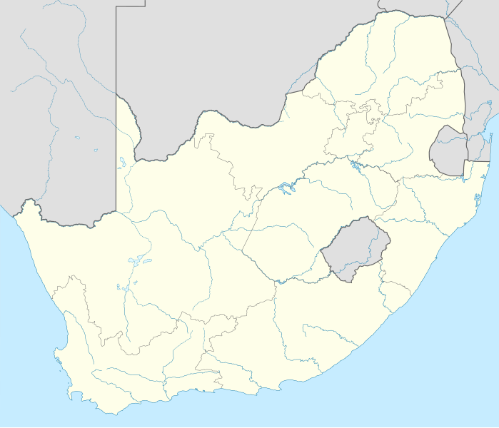
File:South Africa location map.svg


From Wikimedia Commons, the free media repository


Jump to navigation  Jump to search  
File

File history

File usage on Commons

File usage on other wikis

Metadata
File:South Africa location map.svg
Size of this PNG preview of this SVG file: 699 × 599 pixels. Other resolutions: 280 × 240 pixels | 560 × 480 pixels | 896 × 768 pixels | 1,195 × 1,024 pixels | 2,389 × 2,048 pixels | 2,031 × 1,741 pixels.

Original file(SVG file, nominally 2,031 × 1,741 pixels, file size: 644 KB)

File information
Structured data

Captions

Captions


Add a one-line explanation of what this file represents

Summary

[edit]
Description
Deutsch: Positionskarte von Südafrika

Quadratische Plattkarte, N-S-Streckung 110 %. Geographische Begrenzung der Karte:

  • N: 21.8° S
  • S: 35.2° S
  • W: 16.0° O
  • O: 33.2° O
English: Location map of South Africa

Equirectangular projection, N/S stretching 110 %. Geographic limits of the map:

  • N: 21.8° S
  • S: 35.2° S
  • W: 16.0° E
  • E: 33.2° E
Date
Source

own work, using

Author NordNordWest
Other versions

Derivative work:

Kartenwerkstatt
This map has been made or improved in the German Kartenwerkstatt (Map Lab). You can propose maps to improve as well.

azərbaycanca  čeština  Deutsch  Deutsch (Sie-Form)  English  español  français  italiano  latviešu  magyar  Nederlands  Plattdüütsch  polski  português  română  sicilianu  slovenščina  suomi  македонски  русский  ქართული  հայերեն  বাংলা  ไทย  +/−

Licensing

[edit]
I, the copyright holder of this work, hereby publish it under the following licenses:
GNU head Permission is granted to copy, distribute and/or modify this document under the terms of the GNU Free Documentation License, Version 1.2 or any later version published by the Free Software Foundation; with no Invariant Sections, no Front-Cover Texts, and no Back-Cover Texts. A copy of the license is included in the section entitled GNU Free Documentation License.
w:en:Creative Commons
attribution
This file is licensed under the Creative Commons Attribution 3.0 Unported license.
You are free:
  • to share – to copy, distribute and transmit the work
  • to remix – to adapt the work
  • Under the following conditions:
    You may select the license of your choice.

    File history


    Click on a date/time to view the file as it appeared at that time.
    Date/TimeThumbnailDimensionsUserComment
    current16:18, 28 February 2010Thumbnail for version as of 16:18, 28 February 20102,031 × 1,741 (644 KB)NordNordWest (talk | contribs)update
    20:39, 25 February 2009Thumbnail for version as of 20:39, 25 February 20092,032 × 1,742 (654 KB)NordNordWest (talk | contribs){{Information |Description= {{de|Positionskarte von Südafrika}} Quadratische Plattkarte, N-S-Streckung 110 %. Geographische Begrenzung der Karte: * N: 21.8° S * S: 35.2° S * W: 16.0° O * O: 33.2° O {{en|Location map of [[:en:South


    You cannot overwrite this file.


    The following 14 pages use this file:

    User:NordNordWest/Gallery/Location maps

    File:Afrique du Sud Embouchre de la Chalumna river.jpg

    File:Cotyledon tomentosa distribution map.svg

    File:Eastern Cape in South Africa.svg

    File:Free State in South Africa.svg

    File:Gauteng in South Africa.svg

    File:KwaZulu-Natal in South Africa.svg

    File:Limpopo in South Africa.svg

    File:Mpumalanga in South Africa.svg

    File:North West in South Africa.svg

    File:Northern Cape in South Africa.svg

    File:Western Cape in South Africa.svg

    File:Western Cape in South Africa (+outer islands) (+grid + mini map).svg

    File:Western Cape in South Africa (+outer islands) (-grid - mini map).svg


    File usage on other wikis


    The following other wikis use this file:

    Usage on af.wikipedia.org

    Mapungubwe

    Oranjerivier

    Tafelberg

    Duiwelspiek

    Hartsrivier

    Kaapse floraryk

    Sjabloon:Inligtingskas Berg

    Roggeveldberge

    Nasionale Vrouemonument

    Mont-aux-Sources

    Olifantsrivier, Limpopo

    Toorberg (berg)

    Wieg van die Mensdom

    Sjabloon:Inligtingskas Wêrelderfenisgebied

    Richtersveld

    Sterkfontein

    Sjabloon:Liggingkaart Suid-Afrika

    Grassridgedam

    Sondagsrivier

    Klein-Visrivier

    Seweweekspoortpiek

    Kompasberg

    Thabana Ntlenyana

    Die Berg

    Kwaduma

    Ben Macdhui

    Sneeuberg

    Matroosberg

    Bloukranspas

    Moloporivier

    Modderrivier

    Kranskop (koppie)

    Kliprivier, Vrystaat/Mpumalanga grens

    Kliprivier, Gauteng

    Kliprivier, KwaZulu-Natal

    Wilgerivier (Vaal)

    Majubaberg

    Groot-Keirivier

    Keiskammarivier

    Leeukop

    Seinheuwel

    Soutkop

    Mokala- Nasionale Park

    Rooinekpas

    Nonesisnek

    Oudebergpas

    Pitsengpas

    Potrivierpas

    Krokodilrivier (Limpopo)

    Krokodilrivier (Mpumalanga)


    View more global usage of this file.

    Metadata

    This file contains additional information such as Exif metadata which may have been added by the digital camera, scanner, or software program used to create or digitize it. If the file has been modified from its original state, some details such as the timestamp may not fully reflect those of the original file. The timestamp is only as accurate as the clock in the camera, and it may be completely wrong.

    Structured data

    Items portrayed in this file

    depicts

    creator

    some value

    URL: https://commons.wikimedia.org/wiki/user:NordNordWest
    author name string: NordNordWest
    Wikimedia username: NordNordWest

    copyright status

    copyrighted

    copyright license

    GNU Free Documentation License, version 1.2 or later

    Creative Commons Attribution 3.0 Unported

    inception

    25 February 2009

    media type

    image/svg+xml

    checksum

    66323004901fe4822840f941818ffa0f5083e9b3

    determination method: SHA-1

    data size

    659,532 byte

    height

    1,741 pixel

    width

    2,031 pixel


    Retrieved from "https://commons.wikimedia.org/w/index.php?title=File:South_Africa_location_map.svg&oldid=808849756"

    Categories: 
    Location maps of South Africa
    Maps of rivers of South Africa
    Hidden categories: 
    Kartenwerkstatt (SVG)
    License migration redundant
    GFDL
    CC-BY-3.0
    Self-published work
    Files by NordNordWest


    Navigation menu


    Personal tools  


    English
    Not logged in
    Talk
    Contributions
    Create account
    Log in


    Namespaces  


    File
    Discussion