Home  

Random  

Nearby  


Log in  


Settings  


Donate  


About Wikipedia  

Disclaimers  


Wikipedia


Al-Sawalima


Article  

Talk  


Language  

Watch  

Edit  


The printable version is no longer supported and may have rendering errors. Please update your browser bookmarks and please use the default browser print function instead.

Al-Sawalima was a Palestinian Arab village in the Jaffa Subdistrict. It was depopulated during the 1947–1948 Civil War in Mandatory Palestine on March 30, 1948. It was located 11 km northeast of Jaffa, situated 2 km north of the al-'Awja River.

Al-Sawalima
السوالمة
Village
Etymology: es Sûâlimîyeh, the ruin of the Sâlem family[1]

1870s map

1940s map

modern map

1940s with modern overlay map

A series of historical maps of the area around Al-Sawalima (click the buttons)
Al-Sawalima is located in Mandatory Palestine
Al-Sawalima

Al-Sawalima

Location within Mandatory Palestine

Coordinates: 32°06′59N 34°50′51E / 32.11639°N 34.84750°E / 32.11639; 34.84750
Palestine grid134/170
Geopolitical entityMandatory Palestine
SubdistrictJaffa
Date of depopulationMarch 30, 1948[4]
Population
 (1945)
 • Total800[2][3]
Cause(s) of depopulationFear of being caught up in the fighting
Secondary causeInfluence of nearby town's fall
Current LocalitiesNeve Sharett

History

In 1051 AH/1641/2, the Bedouin tribe of al-Sawālima from around Jaffa attacked the villages of Subṭāra, Bayt Dajan, al-Sāfiriya, Jindās, Lydda and Yāzūr belonging to Waqf Haseki Sultan.[5]

In 1882 the PEF's Survey of Western Palestine noted at Khurbet es Sualimiyeh: “Traces of ruins only.“[6]

British Mandate era

In the 1922 census of Palestine conducted by the British Mandate authorities, Sawalmeh had a population of 70 Muslims,[7] increasing in the 1931 census when Es-Sawalmeh had 429 Muslim inhabitants.[8]

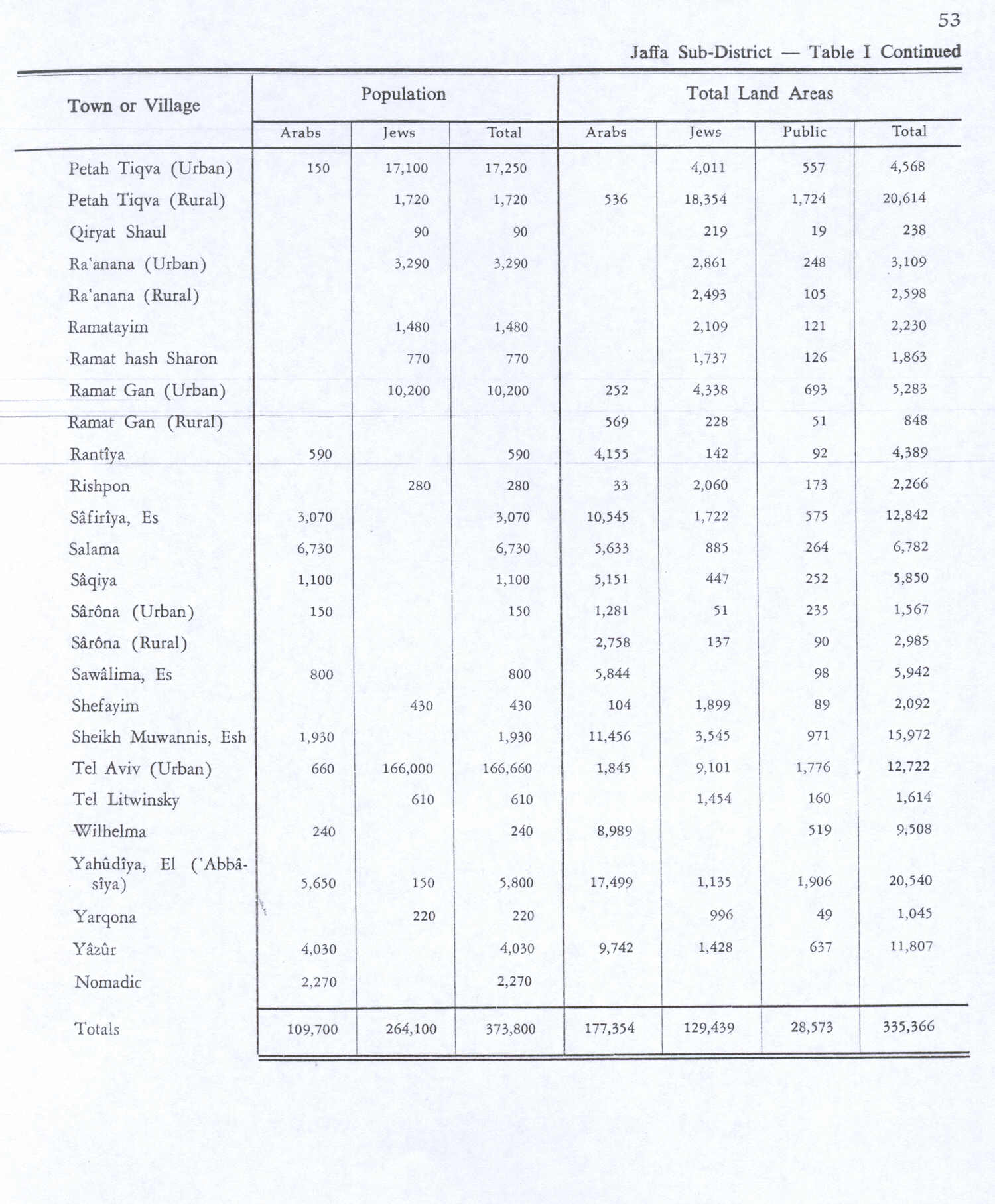
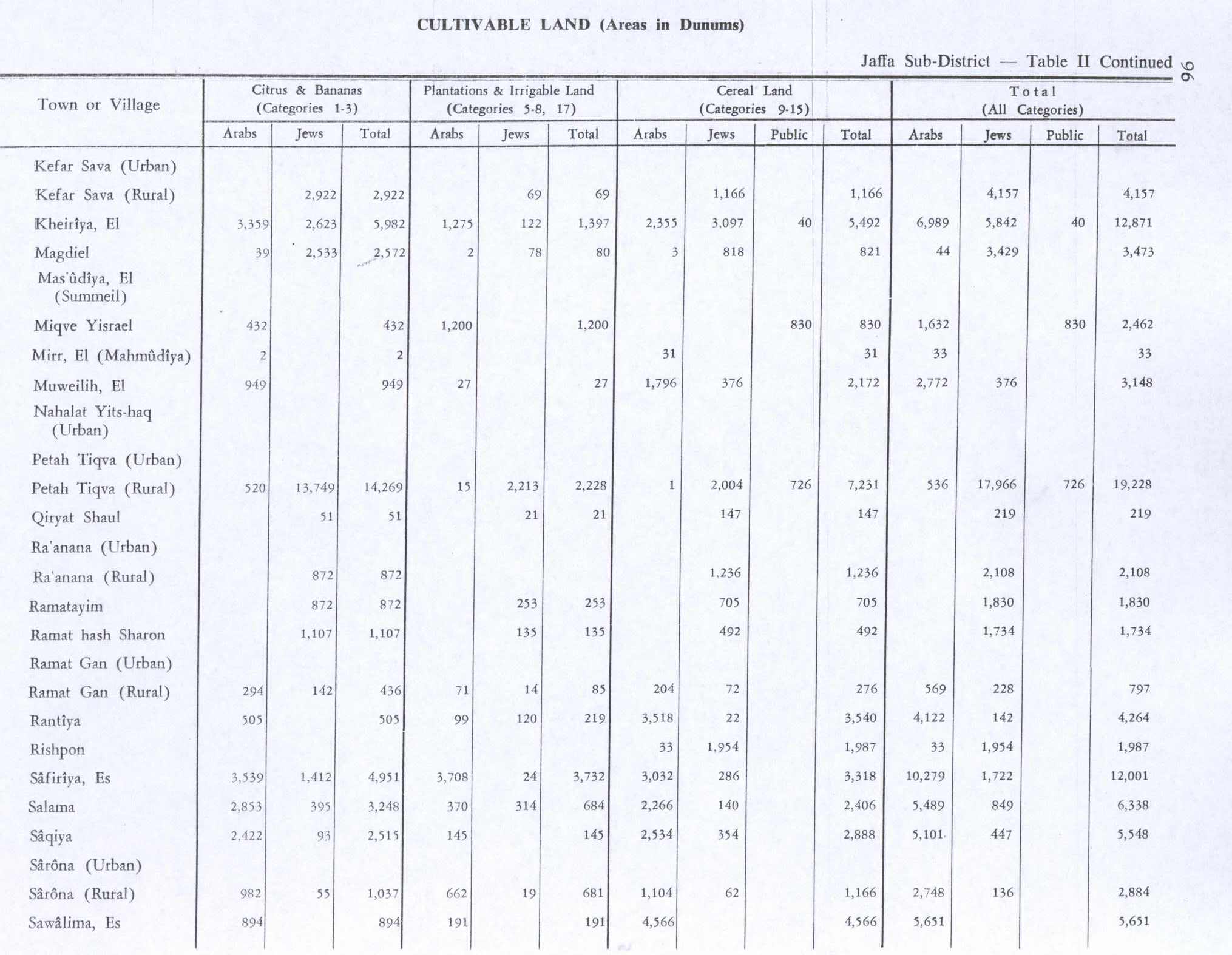
In the 1945 statistics, the village had a population of 800 Muslims,[2] while the total land area was 5,942 dunams, according to an official land and population survey.[3] Of the land area, a total of 894 were used for growing citrus and banana, 191 were for plantations and irrigable land, 4,566 for cereals,[9] while 291 dunams were classified as non-cultivable areas.[10]

Al-Sawalima had an elementary school for boys founded in 1946, with 31 students.[11]

1948 and aftermath

Benny Morris gives "Fear of being caught up in the fighting" and "Influence of nearby town's fall" as reasons for why the village became depopulated on March 30, 1948.[4]

In 1992 the village site was described: "Cactuses grow on the village site. No identifiable traces of the former dwellings (tents or adobe houses) remain. Only the remnants of the one-room school are discernable. A highway runs past the north side of the site."[12]

References

  1. ^ Palmer, 1881, p. 215
  • ^ a b Department of Statistics, 1945, p. 28
  • ^ a b Government of Palestine, Department of Statistics. Village Statistics, April, 1945. Quoted in Hadawi, 1970, p. 53
  • ^ a b Morris, 2004, p. xviii, village #198. Also gives causes of depopulation
  • ^ Marom, Roy (2022-11-01). "Jindās: A History of Lydda's Rural Hinterland in the 15th to the 20th Centuries CE". Lod, Lydda, Diospolis: 13–14.
  • ^ Conder and Kitchener, 1882, SWP II, p. 266
  • ^ Barron, 1923, Table VII, Sub-district of Jaffa, p. 20
  • ^ Mills, 1932, p. 17
  • ^ Government of Palestine, Department of Statistics. Village Statistics, April, 1945. Quoted in Hadawi, 1970, p. 96
  • ^ Government of Palestine, Department of Statistics. Village Statistics, April, 1945. Quoted in Hadawi, 1970, p. 146
  • ^ Khalidi, 1992, p. 258
  • ^ Khalidi, 1992, p. 259
  • Bibliography

  • Conder, C.R.; Kitchener, H. H. (1882). The Survey of Western Palestine: Memoirs of the Topography, Orography, Hydrography, and Archaeology. Vol. 2. London: Committee of the Palestine Exploration Fund.
  • Department of Statistics (1945). Village Statistics, April, 1945. Government of Palestine.
  • Hadawi, S. (1970). Village Statistics of 1945: A Classification of Land and Area ownership in Palestine. Palestine Liberation Organization Research Center. Archived from the original on 2018-12-08. Retrieved 2009-08-18.
  • Khalidi, W. (1992). All That Remains: The Palestinian Villages Occupied and Depopulated by Israel in 1948. Washington D.C.: Institute for Palestine Studies. ISBN 0-88728-224-5.
  • Mills, E., ed. (1932). Census of Palestine 1931. Population of Villages, Towns and Administrative Areas. Jerusalem: Government of Palestine.
  • Morris, B. (2004). The Birth of the Palestinian Refugee Problem Revisited. Cambridge University Press. ISBN 978-0-521-00967-6.
  • Palmer, E. H. (1881). The Survey of Western Palestine: Arabic and English Name Lists Collected During the Survey by Lieutenants Conder and Kitchener, R. E. Transliterated and Explained by E.H. Palmer. Committee of the Palestine Exploration Fund.

  • Retrieved from "https://en.wikipedia.org/w/index.php?title=Al-Sawalima&oldid=1231597007"


    Last edited on 29 June 2024, at 05:07  


    Languages


    العربية
    Bahasa Indonesia
    اردو
     

    Wikipedia


    This page was last edited on 29 June 2024, at 05:07 (UTC).

    Content is available under CC BY-SA 4.0 unless otherwise noted.


    Privacy policy

    About Wikipedia

    Disclaimers

    Contact Wikipedia

    Code of Conduct

    Developers

    Statistics

    Cookie statement

    Terms of Use

    Desktop