Home  

Random  

Nearby  


Log in  


Settings  


Donate  


About Wikipedia  

Disclaimers  


Wikipedia


Arjuni-Morgaon taluka


Article  

Talk  


Language  

Watch  

Edit  


21°26′07N 79°07′25E / 21.4351735°N 79.1235352°E / 21.4351735; 79.1235352

Arjuni Morgaon taluka
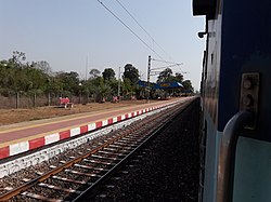
Arjuni Station
Arjuni Station
Map
Arjuni-Morgaon Taluka
Location in Gondia district (MH), India
Country India
StateMaharashtra
RegionsVidharbha
DistrictGondia District
HeadquartersArjuni Morgaon Town
Area
 • Total644.91 km2 (249.00 sq mi)
Population
 • Total143,512
 • Density220/km2 (580/sq mi)
 • Sex ratio
935
Time zoneUTC+5:30 (IST)
PIN [1]
Arjuni Morgaon - 441701
STD Code91-7196
Revenue circle5
Average rainfall1175 mm

Arjuni-Morgaon is a taluka in Arjuni Morgaon Subdivision in Maharashtra, India.[2][3]

Geographic Boundaries

edit

References

edit
  1. ^ "Pin Code List, Pincode Search Engine, Postal Codes of India". www.mapsofindia.com. Retrieved 1 May 2019.
  • ^ Pratibha Pande; Neema Pathak (2019). National Parks and Sanctuaries in Maharashtra: A state profile. Bombay Natural History Society. ISBN 978-81-902647-1-6.
  • ^ T. k. Roy; M. Guruswamy; P. Arokiasamy (1 January 2019). Population, Health, and Development in India: Changing Perspectives. Rawat Publications. ISBN 978-81-7033-882-6.

  • t
  • e

  • Retrieved from "https://en.wikipedia.org/w/index.php?title=Arjuni-Morgaon_taluka&oldid=1224453825"


    Last edited on 18 May 2024, at 14:27  


    Languages


    Wikipedia


    This page was last edited on 18 May 2024, at 14:27 (UTC).

    Content is available under CC BY-SA 4.0 unless otherwise noted.


    Privacy policy

    About Wikipedia

    Disclaimers

    Contact Wikipedia

    Code of Conduct

    Developers

    Statistics

    Cookie statement

    Terms of Use

    Desktop