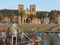
El Kala (Arabic: القالة, Latin Thinisa in Numidia) is a seaport of Algeria, in El Tarf Province, 56 miles (90 km) by rail east of Annaba and 10 miles (16 km) west of the Tunisian frontier. It is the centre of the Algerian and Tunisian coral fisheries and has an extensive industry in the curing of sardines. The harbor is small and exposed to the northeast and west winds.
El Kala
القالة
| |
|---|---|

The old fishing harbor at El Kala facing the decommissioned Saint Cyprien Church
|
El Kala attracts tourists from within and outside the country, especially during the summer. It is home to an exceptional ecosystem and was declared a biosphere reservebyUNESCO in 1990.[1]
Thinisa in Numidia was an ancient city in the Roman provinceofNumidia. It was important enough to become a bishopric. The old fortified town was built on a rocky peninsula about 400 metres long, connected with the mainland by a sand bank.
French and Italian coral fishing companies were interested in the area from as early as 1553. A trade bastion[clarification needed] called "Bastion de France" by its Corsican founders was established during that period principally for the exploitation of red coral and also to facilitate trade between southern France and that part of northern Algeria. The bastion was shut down and returned to the rule of the BeyofConstantine in 1816.
After the occupation of La Calle by the French in 1836, a new town was built up along the coast.
In 1933, the Ancient diocese of Thinisa in Numidia was nominally restored as a Catholic titular see of the lowest (episcopal) rank.
36°54′N 8°27′E / 36.900°N 8.450°E / 36.900; 8.450
It has had the following incumbents:
This article incorporates text from a publication now in the public domain: Chisholm, Hugh, ed. (1911). "La Calle". Encyclopædia Britannica. Vol. 16 (11th ed.). Cambridge University Press. p. 36.
This article about a location in El Taref Province is a stub. You can help Wikipedia by expanding it. |