Debidwar (Bengali: দেবিদ্বার) is an upazilaofComilla District in the Division of Comilla, Bangladesh.[1]
Debidwar
দেবিদ্বার
| |
|---|---|

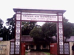
Gate of Gangamandal Raj Institution in Jafarganj
| |
 | |
| Coordinates: 23°36′N 90°59.5′E / 23.600°N 90.9917°E / 23.600; 90.9917 | |
| Country | |
| Division | Chittagong |
| District | Comilla |
| Government | |
| • MP | [[1]] |
| • Upazila Chairman | Md Abul Kalam Azad |
| Area | |
| • Total | 238.36 km2 (92.03 sq mi) |
| Population
(2011)
| |
| • Total | 431,352 |
| • Density | 1,800/km2 (4,700/sq mi) |
| Time zone | UTC+6 (BST) |
| Website | debidwar |
Debidwar is located at 23°36′00″N 90°59′30″E / 23.6000°N 90.9917°E / 23.6000; 90.9917. It has 82,695 households and a total area of 238.36 km2.
According to the 2011 Bangladesh census, Debidwar Upazila had 82,695 households and a population of 431,352. 118,968 (27.58%) were under 10 years of age. Debidwar has a literacy rate (age 7 and over) of 52.83%, compared to the national average of 51.8%, and a sex ratio of 1112 females per 1000 males. 61,418 (14.24%) lived in urban areas.[2][3]
Debidwar Upazila is divided into Debidwar Municipality and 15 union parishads: Barkamta, Boroshalghor, Dakshin Gunaighor, Dhamti, Elahabad, Fatehabad, Jafargonj, Mohanpur, Rajameher, Rasulpur, Subil, Sultanpur, Uttar Gunaighor, Vani, and Yousufpur. The union parishads are subdivided into 129 mauzas and 192 villages.[2]
Debidwar Municipality is subdivided into 9 wards and 22 mahallas.[2]
This section does not cite any sources. Please help improve this sectionbyadding citations to reliable sources. Unsourced material may be challenged and removed. (July 2021) (Learn how and when to remove this message)
|