Home  

Random  

Nearby  


Log in  


Settings  


Donate  


About Wikipedia  

Disclaimers  


Wikipedia


File:Amphoe Uttaradit.svg


File  

Talk  


Language  

Watch  


File

File history

File usage

Global file usage

Metadata
File:Amphoe Uttaradit.svg
Size of this PNG preview of this SVG file: 624 × 600 pixels. Other resolutions: 250 × 240 pixels | 499 × 480 pixels | 799 × 768 pixels | 1,065 × 1,024 pixels | 2,131 × 2,048 pixels | 1,595 × 1,533 pixels.

Original file(SVG file, nominally 1,595 × 1,533 pixels, file size: 195 KB)


Summary

Description
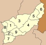
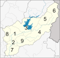
English: Map of the province Uttaradit with the districts (Amphoe) numbered.
  1. Mueang Uttaradit (อำเภอเมืองอุตรดิตถ์)
  • Tron (อำเภอตรอน)
  • Tha Pla (อำเภอท่าปลา)
  • Nam Pat (อำเภอน้ำปาด)
  • Fak Tha (อำเภอฟากท่า)
  • Ban Khok (อำเภอบ้านโคก)
  • Phichai (อำเภอพิชัย)
  • Laplae (อำเภอลับแล)
  • Thong Saen Khan (อำเภอทองแสนขัน)
  • Date
    Source Own work
    Author Hdamm
    Other versions
    Amphoe Uttaradit.png
    SVG development

    InfoField

     
    The source code of this SVGisinvalid due to an error.
     
    This W3C-invalid map was created with Inkscape.


    Licensing

    I, the copyright holder of this work, hereby publish it under the following license:
    w:en:Creative Commons
    attribution share alike
    This file is licensed under the Creative Commons Attribution-Share Alike 3.0 Unported license.
    You are free:
    • to share – to copy, distribute and transmit the work
  • to remix – to adapt the work
  • Under the following conditions:

    Captions

    Add a one-line explanation of what this file represents

    Items portrayed in this file

    depicts

    some value

    18 August 2013

    image/svg+xml

    cd4abc28a9e484c1fbcc6401995100a773549fce

    199,379 byte

    1,533 pixel

    1,595 pixel

    File history


    Click on a date/time to view the file as it appeared at that time.
    Date/TimeThumbnailDimensionsUserComment
    current01:40, 14 February 2015Thumbnail for version as of 01:40, 14 February 20151,595 × 1,533 (195 KB)Potaptlittle adjustments
    19:16, 13 February 2015Thumbnail for version as of 19:16, 13 February 20151,595 × 1,533 (198 KB)PotaptArea change between Tha Pla and Nam Pat districts
    13:53, 18 August 2013Thumbnail for version as of 13:53, 18 August 20131,595 × 1,533 (186 KB)HdammUser created page with UploadWizard


    The following pages on the English Wikipedia use this file (pages on other projects are not listed):

    Uttaradit province


    Global file usage


    The following other wikis use this file:

    Usage on de.wikipedia.org

    Uttaradit (Provinz)


    Usage on ka.wikipedia.org


    Usage on th.wikipedia.org


    Usage on zh.wikipedia.org


    Metadata

    This file contains additional information, probably added from the digital camera or scanner used to create or digitize it.

    If the file has been modified from its original state, some details may not fully reflect the modified file.


    Retrieved from "https://en.wikipedia.org/wiki/File:Amphoe_Uttaradit.svg"


    Languages


    This page is not available in other languages.
     

    Wikipedia


    Privacy policy

    About Wikipedia

    Disclaimers

    Contact Wikipedia

    Code of Conduct

    Developers

    Statistics

    Cookie statement

    Terms of Use

    Desktop