Home  

Random  

Nearby  


Log in  


Settings  


Donate  


About Wikipedia  

Disclaimers  


Wikipedia


File:Cartesian-coordinate-system.svg


File  

Talk  


Language  

Watch  


File

File history

File usage

Global file usage

Metadata
File:Cartesian-coordinate-system.svg
Size of this PNG preview of this SVG file: 606 × 600 pixels. Other resolutions: 243 × 240 pixels | 485 × 480 pixels | 776 × 768 pixels | 1,035 × 1,024 pixels | 2,070 × 2,048 pixels | 661 × 654 pixels.

Original file(SVG file, nominally 661 × 654 pixels, file size: 2 KB)


لغرض التعليم

Summary

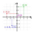
Description A small portion of the Cartesian coordinate system, showing the origin, axes, and the four quadrants, with illustrative points and grid.
Date
Source Made by K. Bolino (Kbolino), based upon earlier versions.
Author K. Bolino
Permission
(Reusing this file)

Insofar as to the work original to me,

Public domain This work has been released into the public domain by its author, Kbolino. This applies worldwide.

In some countries this may not be legally possible; if so:
Kbolino grants anyone the right to use this work for any purpose, without any conditions, unless such conditions are required by law.

Other versions

Derivative works of this file:

Older versions by 345Kaionen.wikipedia, licensed under:

345Kai at the English-language Wikipedia, the copyright holder of this work, hereby publishes it under the following license:
GNU head Permission is granted to copy, distribute and/or modify this document under the terms of the GNU Free Documentation License, Version 1.2 or any later version published by the Free Software Foundation; with no Invariant Sections, no Front-Cover Texts, and no Back-Cover Texts. A copy of the license is included in the section entitled GNU Free Documentation License.
w:en:Creative Commons
attribution share alike
This file is licensed under the Creative Commons Attribution-Share Alike 3.0 Unported license.
Attribution: 345Kai
You are free:
  • to share – to copy, distribute and transmit the work
  • to remix – to adapt the work
Under the following conditions:
  • attribution – You must give appropriate credit, provide a link to the license, and indicate if changes were made. You may do so in any reasonable manner, but not in any way that suggests the licensor endorses you or your use.
  • share alike – If you remix, transform, or build upon the material, you must distribute your contributions under the same or compatible license as the original.
This licensing tag was added to this file as part of the GFDL licensing update.

Originally from en.wikipedia; description page is (was) here

  • 01:33, 19 April 2006 345Kai 770x790 (8,555 bytes)
  • 01:31, 19 April 2006 345Kai 770x790 (8,555 bytes)
  • 00:36, 19 April 2006 345Kai 770x790 (8,409 bytes)
  • 00:30, 19 April 2006 345Kai 780x790 (8,556 bytes)
SVG development

InfoField

 
The SVG code is valid.
 
This vector image was created with Inkscape…important.
 
This file uses translateable embedded text.

Captions

Cartesian coordinate system

Items portrayed in this file

depicts

8 September 2008

image/svg+xml

e8f7ee6041a1c50a8dec6e7462944775fd7654a8

53,727 byte

354 pixel

354 pixel

File history


Click on a date/time to view the file as it appeared at that time.
(newest | oldest) View (newer 10 | ) (10 | 20| 50| 100 | 250 | 500)
Date/TimeThumbnailDimensionsUserComment
current16:46, 20 May 2024Thumbnail for version as of 16:46, 20 May 2024661 × 654 (2 KB)Д.ИльинOptimization, fix hml-errors
10:14, 21 October 2017Thumbnail for version as of 10:14, 21 October 2017354 × 354 (52 KB)ㅂㄱㅇReverted to version as of 03:11, 22 July 2011 (UTC): minus sign is needed for negative
14:39, 13 January 2015Thumbnail for version as of 14:39, 13 January 2015300 × 300 (2 KB)Krishnavedalaadded missing arrows indicating +ve axis directions
14:32, 13 January 2015Thumbnail for version as of 14:32, 13 January 2015300 × 300 (2 KB)Krishnavedalasimplified drawing
03:11, 22 July 2011Thumbnail for version as of 03:11, 22 July 2011354 × 354 (52 KB)Johnuniqremove left and down arrows on each axis per talk
08:57, 8 September 2008Thumbnail for version as of 08:57, 8 September 2008354 × 354 (53 KB)Kbolinomissed the y
08:54, 8 September 2008Thumbnail for version as of 08:54, 8 September 2008354 × 354 (50 KB)Kbolinobrute force: fonts to paths (the sans-serif text is DejaVu Sans, which is a PD modification to Bitstream Vera Sans, license at http://dejavu.sourceforge.net/wiki/index.php/License; the serif text is Gentium, under the SIL Open Font License)
08:45, 8 September 2008Thumbnail for version as of 08:45, 8 September 2008354 × 354 (27 KB)Kbolinofix fonts (hopefully)
08:26, 8 September 2008Thumbnail for version as of 08:26, 8 September 2008354 × 354 (24 KB)Kbolino{{Information |Description=A small portion of the Cartesian coordinate system, showing the origin, axes, and the four quadrants, with illustrative points and grid. |Source=Made by K. Bolino (Kbolino), based upon earlier versions |Date=8 S
06:21, 22 June 2007Thumbnail for version as of 06:21, 22 June 2007429 × 425 (21 KB)Cronholm144tweaked image

(newest | oldest) View (newer 10 | ) (10 | 20| 50| 100 | 250 | 500)


The following pages on the English Wikipedia use this file (pages on other projects are not listed):

Abscissa and ordinate

Analytic geometry

Cartesian coordinate system

Cartesian product

Coordinate system

Elementary mathematics

Euclidean plane

Euclidean planes in three-dimensional space

Plane (mathematics)

User:345Kai

Wikipedia talk:WikiProject Mathematics/Archive/2011/Jul


Global file usage


The following other wikis use this file:

Usage on af.wikipedia.org

Koördinatestelsel

Cartesiese koördinatestelsel


Usage on an.wikipedia.org

Sistema de coordenadas


Usage on ar.wikipedia.org

هندسة تحليلية

إحداثيات

نظام إحداثيات

فضاء ثنائي الأبعاد


Usage on ast.wikipedia.org

Coordenada

Xeometría analítica

Coordenaes cartesianes

Historia de la xeometría


Usage on as.wikipedia.org

 িি


Usage on azb.wikipedia.org

تحلیلی هندسه


Usage on az.wikipedia.org

Analitik həndəsə

Karteziyan koordinat sistemi

Həndəsə (Dekart)


Usage on az.wiktionary.org

absis


Usage on ba.wikipedia.org

Аналитик геометрия


Usage on be-tarask.wikipedia.org

Аналітычная геамэтрыя

Сыстэма каардынат


Usage on be.wikipedia.org

Аналітычная геаметрыя

Сістэма каардынат


Usage on bg.wikipedia.org

Координатна система

Двумерно пространство


Usage on bn.wikipedia.org


িি 

 িি

  ি


Usage on bs.wikipedia.org

Descartesov koordinatni sistem


Usage on ca.wikipedia.org

Sistema de coordenades cartesianes

Usuari:Mcapdevila/Història de la geometria

Usuari:Mcapdevila/Analogia de Michelson-Morley

Espai bidimensional


Usage on ca.wikibooks.org

Matemàtiques (Prova d'accés a cicles formatius de grau superior)/Nombres complexos


Usage on ckb.wikipedia.org

سیستمی پۆتانەکان

خاڵی بنەڕەت (ماتماتیک)

سیستمی پۆتانی دێکارتی

جووتە ڕێکخراو


Usage on cs.wikipedia.org

Soustava souřadnic

Kartézská soustava souřadnic

Pravidelná síť


Usage on cs.wikiversity.org

Analytická geometrie (přednáška)


Usage on cv.wikipedia.org

Аналитикăллă геометри

Ик виçеллĕ уçлăх

Координатсен тытăмĕ


Usage on cy.wikipedia.org

System gyfesurynnau

Gofod dau ddimensiwn

Geometreg ddadansoddol


Usage on da.wikipedia.org

Koordinatsystem

Kartesisk koordinatsystem


View more global usage of this file.

Metadata

This file contains additional information, probably added from the digital camera or scanner used to create or digitize it.

If the file has been modified from its original state, some details may not fully reflect the modified file.


Retrieved from "https://en.wikipedia.org/wiki/File:Cartesian-coordinate-system.svg"


Languages


This page is not available in other languages.
 

Wikipedia


Privacy policy

About Wikipedia

Disclaimers

Contact Wikipedia

Code of Conduct

Developers

Statistics

Cookie statement

Terms of Use

Desktop