Home  

Random  

Nearby  


Log in  


Settings  


Donate  


About Wikipedia  

Disclaimers  


Wikipedia


File:Ceredigion UK location map.svg


File  

Talk  


Language  

Watch  


File

File history

File usage

Global file usage

Metadata
File:Ceredigion UK location map.svg
Size of this PNG preview of this SVG file: 717 × 600 pixels. Other resolutions: 287 × 240 pixels | 574 × 480 pixels | 918 × 768 pixels | 1,224 × 1,024 pixels | 2,448 × 2,048 pixels | 1,425 × 1,192 pixels.

Original file(SVG file, nominally 1,425 × 1,192 pixels, file size: 799 KB)


Description

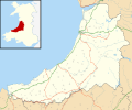
Blank map of Ceredigion, UK with the following information shown:

  • Administrative borders
  • Coastline, lakes and rivers
  • Roads and railways
  • Urban areas

Equirectangular map projection on WGS 84 datum, with N/S stretched 160%

Geographic limits:

  • West: 4.75W
  • East: 3.64W
  • North: 52.58N
  • South: 52.00N
Date
Source

Ordnance Survey OpenData.

Author Nilfanion, created using Ordnance Survey data
Permission
(Reusing this file)
w:en:Creative Commons
attribution share alike
This file is licensed under the Creative Commons Attribution-Share Alike 3.0 Unported license.
Attribution: Contains Ordnance Survey data © Crown copyright and database right
You are free:
  • to share – to copy, distribute and transmit the work
  • to remix – to adapt the work
  • Under the following conditions:
    • attribution – You must give appropriate credit, provide a link to the license, and indicate if changes were made. You may do so in any reasonable manner, but not in any way that suggests the licensor endorses you or your use.
    • share alike – If you remix, transform, or build upon the material, you must distribute your contributions under the same or compatible license as the original.
    Other versions File:Ceredigion UK map.svg - Blank map

    Captions

    Map of Ceredigion

    Items portrayed in this file

    depicts

    26 September 2010

    image/svg+xml

    cea6e7460f6fd1ff40c73b3e9a8418a8f2749003

    818,068 byte

    1,192 pixel

    1,425 pixel

    File history


    Click on a date/time to view the file as it appeared at that time.
    Date/TimeThumbnailDimensionsUserComment
    current19:31, 26 September 2010Thumbnail for version as of 19:31, 26 September 20101,425 × 1,192 (799 KB)Nilfanion{{Information |Description=Blank map of Ceredigion, UK with the following information shown: *Administrative borders *Coastline, lakes and rivers *Roads and railways *Urban areas Equirectangular map projection on WGS 84 datum, with N/S s


    More than 100 pages use this file. The following list shows the first 100 pages that use this file only. A full list is available.

    Aberaeron

    Abermagwr

    Aberporth

    Aberystwyth

    Aberystwyth Arts Centre

    Adpar

    Alltyblacca

    Betws Ifan

    Beulah, Ceredigion

    Blaenplwyf transmitting station

    Blaenrheidol

    Bont Goch

    Bontnewydd, Ceredigion

    Borth

    Bow Street, Ceredigion

    Bow Street railway station

    Bremia (fort)

    Capel Dewi, Faenor

    Capel Dewi, Llandysul

    Cardigan, Ceredigion

    Cardigan and District Community Hospital

    Ceredigion

    Ceredigion Museum

    Chancery, Ceredigion

    Ciliau Aeron

    Comins Coch

    Cribyn

    Cwmystwyth

    Daren

    Drefach, Ceredigion

    Faenor, Ceredigion

    Furnace, Ceredigion

    Gilfachrheda

    Glandyfi

    Glynarthen

    Gorsgoch

    Gwbert

    Hafod Uchtryd

    Harbourmaster Hotel

    Internal Fire Museum of Power

    Lampeter

    List of Roman-to-modern scheduled monuments in Ceredigion

    List of Sites of Special Scientific Interest in Ceredigion

    List of monastic houses in Wales

    List of prehistoric scheduled monuments in Ceredigion

    Llanarth, Ceredigion

    Llanbadarn Fawr, Ceredigion

    Llanddewi Brefi

    Llandre

    Llandyfriog transmitting station

    Llandygwydd

    Llandysul

    Llanfair Clydogau

    Llanfarian

    Llanfihangel y Creuddyn

    Llangeitho

    Llangoedmor

    Llangorwen

    Llangrannog

    Llangwyryfon

    Llangybi, Ceredigion

    Llangynfelyn

    Llanon

    Llechryd

    Lledrod

    Mwnt

    Nantcwnlle

    New Quay

    Parc-llyn

    Pen-y-garn, Ceredigion

    Penbryn

    Penparcau

    Penrhyn-coch

    Penuwch

    Pont-rhyd-y-groes

    Pontrhydfendigaid

    Pontsiân

    Rhydlewis

    Rhydowen

    Rhydypennau, Ceredigion

    Sarn Gynfelyn

    Silian, Ceredigion

    Soar y mynydd

    St Michael's Church, Tremain

    Swyddffynnon

    Taigwynion

    Tal-y-bont, Ceredigion

    Talgarreg

    Trawscoed fort

    Trawsgoed

    Tre-Taliesin

    Tregaron

    Tregaron Hospital

    Troed y Rhiw

    Wallog

    Y Ferwig

    Ynyslas

    Ysbyty Ystwyth

    Ystrad Meurig

    User:Piggery Poke/sandbox


    View more links to this file.

    Global file usage


    The following other wikis use this file:

    Usage on ar.wikipedia.org

    قالب:Location map Wales Ceredigion


    Usage on azb.wikipedia.org

    لانقرانوق

    آبریستویث


    Usage on ceb.wikipedia.org

    Plantilya:Location map Wales Ceredigion


    Usage on cy.wikipedia.org

    Nodyn:Location map Wales Ceredigion


    Usage on da.wikipedia.org

    Ceredigion


    Usage on eo.wikipedia.org

    Ceredigion


    Usage on es.wikipedia.org

    Cardigan (Gales)

    Aberystwyth

    Wikiproyecto:Ilustración/Taller de Cartografía/Realizaciones/Europa

    Plantilla:Mapa de localización de Ceredigion

    Henfynyw

    Llechryd

    Llanrhystud

    Aberporth

    Llanon

    Llanilar

    Pontrhydfendigaid

    Penrhyn-coch

    Llandysul

    Llandre

    Llanbadarn Fawr

    Tal-y-bont

    Penrhiw-llan

    New Quay

    Ystrad Aeron

    Llanarth

    Tregaron

    Bow Street

    Borth


    Usage on fa.wikipedia.org

    الگو:Location map Wales Ceredigion

    لنگیتهو

    لانگرانوگ

    لدرود


    Usage on fr.wikipedia.org

    Llangrannog

    Modèle:Géolocalisation/Ceredigion

    Cofiwch Dryweryn

    Penparc


    Usage on gv.wikipedia.org

    Ceredigion


    Usage on ja.wikipedia.org


    :Location map/data/Wales Ceredigion

    :Location map/data/Wales Ceredigion/doc


    Usage on kn.wikipedia.org

    :Location map Wales Ceredigion


    Usage on nl.wikipedia.org

    Sjabloon:Positiekaart Ceredigion

    Gebruiker:HugoNL00/Kladblok/Dierentuinen


    Usage on pl.wikipedia.org

    Aberystwyth

    Ceredigion

    Lampeter

    Cardigan (Walia)

    Aberaeron


    View more global usage of this file.

    Metadata

    This file contains additional information, probably added from the digital camera or scanner used to create or digitize it.

    If the file has been modified from its original state, some details may not fully reflect the modified file.


    Retrieved from "https://en.wikipedia.org/wiki/File:Ceredigion_UK_location_map.svg"


    Languages


    This page is not available in other languages.
     

    Wikipedia


    Privacy policy

    About Wikipedia

    Disclaimers

    Contact Wikipedia

    Code of Conduct

    Developers

    Statistics

    Cookie statement

    Terms of Use

    Desktop