Home  

Random  

Nearby  


Log in  


Settings  


Donate  


About Wikipedia  

Disclaimers  


Wikipedia


File:Chile location map.svg


File  

Talk  


Language  

Watch  


File

File history

File usage

Global file usage

Metadata
File:Chile location map.svg
Size of this PNG preview of this SVG file: 267 × 600 pixels. Other resolutions: 107 × 240 pixels | 213 × 480 pixels | 342 × 768 pixels | 455 × 1,024 pixels | 911 × 2,048 pixels | 1,183 × 2,658 pixels.

Original file(SVG file, nominally 1,183 × 2,658 pixels, file size: 925 KB)


Summary

Description
Deutsch: Positionskarte von Chile

Quadratische Plattkarte, N-S-Streckung 115 %. Geographische Begrenzung der Karte:

  • N: 17.4° S
  • S: 56.5° S
  • W: 81.5° W
  • O: 61.5° W
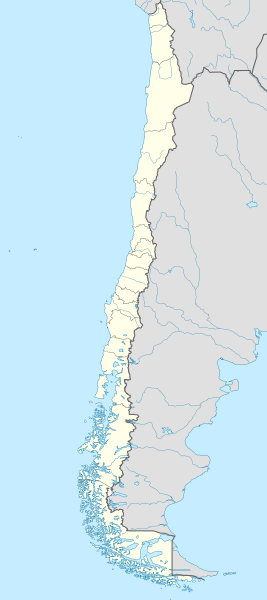
English: Location map of Chile

Equirectangular projection, N/S stretching 115 %. Geographic limits of the map:

  • N: 17.4° S
  • S: 56.5° S
  • W: 81.5° W
  • E: 61.5° W
Español: Mapa de localización de Chile

Proyección Equirectangular, N/S con una extensión de 115 %. Límites geográficos del mapa:

  • N: 17.4° S
  • S: 56.5° S
  • O: 81.5° O
  • E: 61.5° O
Date
Source

own work, using

  • United States National Imagery and Mapping Agency data
  • World Data Base II data
Author NordNordWest
Other versions

Derivative works of this file:

Kartenwerkstatt
This map has been made or improved in the German Kartenwerkstatt (Map Lab). You can propose maps to improve as well.

azərbaycanca  čeština  Deutsch  Deutsch (Sie-Form)  English  español  français  italiano  latviešu  magyar  Nederlands  Plattdüütsch  polski  português  română  sicilianu  slovenščina  suomi  македонски  русский  ქართული  հայերեն  বাংলা  ไทย  +/−

Licensing

I, the copyright holder of this work, hereby publish it under the following licenses:
GNU head Permission is granted to copy, distribute and/or modify this document under the terms of the GNU Free Documentation License, Version 1.2 or any later version published by the Free Software Foundation; with no Invariant Sections, no Front-Cover Texts, and no Back-Cover Texts. A copy of the license is included in the section entitled GNU Free Documentation License.
w:en:Creative Commons
attribution share alike
This file is licensed under the Creative Commons Attribution-Share Alike 3.0 Unported license.
You are free:
  • to share – to copy, distribute and transmit the work
  • to remix – to adapt the work
  • Under the following conditions:
    You may select the license of your choice.

    Captions

    Map of Chile

    Items portrayed in this file

    depicts

    some value

    author name string: NordNordWest

    20 May 2008

    image/svg+xml

    9bc19cbea805182328e6b94da3b7814d41ba401d

    947,224 byte

    2,658 pixel

    1,183 pixel

    File history


    Click on a date/time to view the file as it appeared at that time.
    (newest | oldest) View (newer 10 | ) (10 | 20| 50| 100 | 250 | 500)
    Date/TimeThumbnailDimensionsUserComment
    current22:46, 15 August 2023Thumbnail for version as of 22:46, 15 August 20231,183 × 2,658 (925 KB)JanitoalevicFixed Aysén & Magallanes and Chilean Antarctica Regions border.
    22:54, 5 September 2018Thumbnail for version as of 22:54, 5 September 20181,183 × 2,658 (925 KB)JanitoalevicÑuble Region
    20:30, 3 December 2017Thumbnail for version as of 20:30, 3 December 20171,183 × 2,658 (921 KB)Janitoaleviccolor error.
    20:28, 3 December 2017Thumbnail for version as of 20:28, 3 December 20171,183 × 2,658 (921 KB)JanitoalevicFixed Argentina's Lake Nahuel Huapi
    20:25, 3 December 2017Thumbnail for version as of 20:25, 3 December 20171,183 × 2,658 (920 KB)Janitoalevic.
    21:50, 2 December 2017Thumbnail for version as of 21:50, 2 December 20171,183 × 2,658 (920 KB)JanitoalevicFixed Argentina-Bolivia border
    21:46, 2 December 2017Thumbnail for version as of 21:46, 2 December 20171,183 × 2,658 (920 KB)Janitoalevic.
    00:42, 30 August 2017Thumbnail for version as of 00:42, 30 August 20171,183 × 2,658 (919 KB)JanitoalevicFixed size
    23:30, 20 August 2017Thumbnail for version as of 23:30, 20 August 20171,262 × 2,835 (910 KB)JanitoalevicRemoved Ñuble Region (Will be fully implemented in 2018)
    01:00, 20 August 2017Thumbnail for version as of 01:00, 20 August 20171,262 × 2,835 (914 KB)JanitoalevicAdded Ñuble Region & more precise borders

    (newest | oldest) View (newer 10 | ) (10 | 20| 50| 100 | 250 | 500)


    More than 100 pages use this file. The following list shows the first 100 pages that use this file only. A full list is available.

    1920 South American Championship

    1941 South American Championship

    1962 FIFA World Cup

    1991 Copa América

    Ancud

    Angol

    Antofagasta

    Antofagasta Province

    Arauco Province

    Arica

    Arica Province

    Arturo Merino Benítez International Airport

    Battle of Angamos

    Battle of Chacabuco

    Calama, Chile

    Cañete, Chile

    Cerrillos, Chile

    Cerro Navia

    Chañaral Island

    Chilean Civil War of 1891

    Chillán

    Chuquicamata

    Colonia Dignidad

    Concepción, Chile

    Conchalí

    Copiapó

    Coquimbo

    Cordillera Province, Chile

    Coyhaique

    Curicó Province

    El Bosque, Chile

    El Tepual International Airport

    European Southern Observatory

    Frutillar

    Huechuraba

    Illapel

    Independencia, Chile

    Iquique

    Iquique Province

    Juan Fernández Islands

    La Cisterna

    La Florida, Chile

    La Granja, Chile

    La Negra (industrial complex)

    La Pintana

    La Reina

    La Serena, Chile

    Las Condes

    Linares, Chile

    Llanquihue Province

    Lo Barnechea

    Lo Espejo

    Lo Prado

    Los Ángeles, Chile

    Macul

    Maipú, Chile

    Mejillones

    Ovalle

    Palena Province

    Parinacota Province

    Parral, Chile

    Pedro Aguirre Cerda, Chile

    Peñalolén

    Porvenir, Chile

    Providencia, Chile

    Pudahuel

    Puerto Aysén

    Puerto Montt

    Puerto Toro

    Puerto Varas

    Puerto Williams

    Putre

    Quilicura

    Quillota

    Quinta Normal

    Rancagua

    Recoleta, Chile

    Renca

    Robinson Crusoe Island

    Río Negro, Chile

    Saavedra, Chile

    San Joaquín

    San Miguel, Chile

    San Pedro de Atacama

    San Ramón, Chile

    Santa Clara Island

    Santa Inés Island

    Santiago Province, Chile

    Santo Domingo, Chile

    Talca

    Talca Province

    Talcahuano

    Temuco

    Teno

    Tocopilla

    University of Tarapacá

    Valparaíso

    Vicuña, Chile

    Vitacura

    Viña del Mar


    View more links to this file.

    Global file usage


    The following other wikis use this file:

    Usage on af.wikipedia.org

    Antofagasta

    Pichilemu

    FIFA Sokker-Wêreldbekertoernooi in 1962

    Chillán

    Los Ángeles (Chili)

    Talcahuano

    Quinta Normal

    Temuco

    Puerto Montt

    Punta Arenas

    Coyhaique

    Valdivia

    Castro (Chili)

    San Pedro de la Paz

    Villa Alemana

    Sjabloon:Liggingkaart Chili

    Penco

    Hualpén

    Chiguayante

    Hualqui

    Coronel (Chili)

    Lota

    Tomé

    La Serena

    Arica

    Monte Águila (Chili)

    Arturo Merino Benítez Internasionale Lughawe


    Usage on als.wikipedia.org

    Chillán

    Vorlage:Positionskarte Chile

    Valparaíso

    Santiago de Chile

    Salamanca (Chile)

    Fußball-Weltmeisterschaft 1962


    Usage on an.wikipedia.org

    Santiago de Chile

    Pichilemu

    Concepción (Chile)

    Talcahuano

    Vitacura

    Lo Barnechea

    Villa Alemana

    San Pedro de la Paz

    Chillán

    Angol

    Hualqui

    Valparaíso

    Aeropuerto Internacional Carriel Sur

    Yumbel

    Salamanca (Chile)

    La Serena (Chile)

    Punta Arenas


    View more global usage of this file.

    Metadata

    This file contains additional information, probably added from the digital camera or scanner used to create or digitize it.

    If the file has been modified from its original state, some details may not fully reflect the modified file.


    Retrieved from "https://en.wikipedia.org/wiki/File:Chile_location_map.svg"


    Languages


    This page is not available in other languages.
     

    Wikipedia


    Privacy policy

    About Wikipedia

    Disclaimers

    Contact Wikipedia

    Code of Conduct

    Developers

    Statistics

    Cookie statement

    Terms of Use

    Desktop