Home  

Random  

Nearby  


Log in  


Settings  


Donate  


About Wikipedia  

Disclaimers  


Wikipedia


File:China Xinjiang rel location map.svg


File  

Talk  


Language  

Watch  


File

File history

File usage

Global file usage

Metadata
File:China Xinjiang rel location map.svg
Size of this PNG preview of this SVG file: 686 × 599 pixels. Other resolutions: 275 × 240 pixels | 550 × 480 pixels | 879 × 768 pixels | 1,172 × 1,024 pixels | 2,345 × 2,048 pixels | 2,220 × 1,939 pixels.

Original file(SVG file, nominally 2,220 × 1,939 pixels, file size: 1.46 MB)


Summary

Description
Deutsch: Positionskarte von Xinjiang, Volksrepublik China
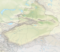
English: Location map of Xinjiang, People's Republic of China

Equirectangular projection, vertical stretching 135 %
Border coordinates

49.4
73.2←↕→96.7
34.2
 Info This map is part of a series of location maps with unified standards: SVG as file format, standardised colours and name scheme. The boundaries on these maps always show the de facto situation and do not imply any endorsement or acceptance. In case of changes of the shown area the file is updated. The old version will be uploaded as a new file and thus is still available.
Date
Source

Own work using:

  • United States National Imagery and Mapping Agency data
  • World Data Base II data
  • ETOPO1 data
Author NordNordWest
Other versions
Kartenwerkstatt
This map has been made or improved in the German Kartenwerkstatt (Map Lab). You can propose maps to improve as well.

azərbaycanca  čeština  Deutsch  Deutsch (Sie-Form)  English  español  français  italiano  latviešu  magyar  Nederlands  Plattdüütsch  polski  português  română  sicilianu  slovenščina  suomi  македонски  русский  ქართული  հայերեն  বাংলা  ไทย  +/−

Licensing

Usage of this file with:

Map: NordNordWest, Licence: Creative Commons by-sa-3.0 de

explanatory notes: Legally binding is only the full legalcode. For a free usage I recommend to respect the following licence conditions:
1. Provide my name as given above: NordNordWest,
2. a copy of, or the URI for, the applicable license: https://creativecommons.org/licenses/by-sa/3.0/de/legalcode,
3. the title of the work,
4. in the case of an adaptation, a credit identifying the use of the work in the adaptation.
This license and the rights granted hereunder will terminate automatically upon any breach by you of the terms of this license. Any of the above conditions can be waived if you get permission from the copyright holder. If you have questions or wish differing conditions, please contact me through nnwest@t-online.deormy discussion page

w:en:Creative Commons
attribution share alike
This file is licensed under the Creative Commons Attribution-Share Alike 3.0 Germany license.
Attribution: Karte: NordNordWest, Lizenz: Creative Commons by-sa-3.0 de
You are free:
  • to share – to copy, distribute and transmit the work
  • to remix – to adapt the work
  • Under the following conditions:

    Captions

    Add a one-line explanation of what this file represents

    Items portrayed in this file

    depicts

    14 February 2020

    image/svg+xml

    e2abae358fbd119441dae31101d91c7434bd27ba

    1,532,032 byte

    1,939 pixel

    2,220 pixel

    File history


    Click on a date/time to view the file as it appeared at that time.
    Date/TimeThumbnailDimensionsUserComment
    current20:05, 14 February 2020Thumbnail for version as of 20:05, 14 February 20202,220 × 1,939 (1.46 MB)NordNordWest== {{int:filedesc}} == {{Information |Description= {{de|1=Positionskarte von Xinjiang, Volksrepublik China}} {{en|1=Location map of Xinjiang, People's Republic of China}} {{Location map series N |stretching=135 |top=49.4 |bottom=34.2 |left=73.2 |right=96.7 }} |Source={{Own using}} * United States National Imagery and Mapping Agency data * World Data Base II data * ETOPO1 data |Date=2020-02-14 |Author={{U|NordNordWest}} |Permission= |other_versions=<gallery>China Xinjiang adm location map.svg<...


    More than 100 pages use this file. The following list shows the first 100 pages that use this file only. A full list is available.

    2017 Taxkorgan earthquake

    2024 Uqturpan earthquake

    Akqi County

    Aksu City

    Alashankou

    Almaliq, Xinjiang

    Altay City

    Altyn Mosque

    Artush

    Astana Cemetery

    Barkol Kazakh Autonomous County

    Barkol Tagh

    Beshbalik

    Bezeklik Caves

    Bogda Shan

    Bole, Xinjiang

    Bukadaban Feng

    Changji

    Cherchen Man

    Fuhai County

    Fukang

    Gaochang

    Habahe County

    Hami

    Hotan

    Huyanghe

    Jiaohe ruins

    Karamay

    Karasahr

    Kashgar

    Khan Tengri

    Khorgos

    Kizil Caves

    Kizilgaha caves

    Korla

    Kucha

    Kumtura Caves

    Kuqa, Xinjiang

    Kuytun

    Lop Nur

    Loulan Kingdom

    Maralbexi County

    Miran (Xinjiang)

    Niya ruins

    Onsu County

    Payzawat County

    Poskam County, Xinjiang

    Princess of Xiaohe

    Qiemo County

    Qiemo Town

    Qing reconquest of Xinjiang

    Ruoqiang County

    Ruoqiang Town

    Sampul

    Shikshin Temple

    Shufu County

    Shule County

    Subashi Temple

    Taghdumbash Pamir

    Tarim Basin

    Tongtiandong

    Treaty of Saint Petersburg (1881)

    Tumxuk

    Turpan

    Uqturpan County

    Wusu

    Xayar County

    Yakub Beg of Yettishar

    Yarkant County

    Yengisar County

    Yining

    Yining County

    Ürümqi

    User:Benjamin Trovato/sandbox

    User:Hike395/test mountain bot

    User:Ty654/List of earthquakes from 1900-1949 exceeding magnitude 7+

    User:Ty654/List of earthquakes from 1905-1909 exceeding magnitude 6+

    User:Ty654/List of earthquakes from 1910-1919 exceeding magnitude 6+

    User:Ty654/List of earthquakes from 1920-1929 exceeding magnitude 6+

    User:Ty654/List of earthquakes from 1930-1939 exceeding magnitude 6+

    User:Ty654/List of earthquakes from 1940-1949 exceeding magnitude 6+

    User:Ty654/List of earthquakes from 1950-1954 exceeding magnitude 6+

    User:Ty654/List of earthquakes from 1950-1999 exceeding magnitude 7+

    User:Ty654/List of earthquakes from 1955-1959 exceeding magnitude 6+

    User:Ty654/List of earthquakes from 1960-1964 exceeding magnitude 6+

    User:Ty654/List of earthquakes from 1965-1969 exceeding magnitude 6+

    User:Ty654/List of earthquakes from 1970-1974 exceeding magnitude 6+

    User:Ty654/List of earthquakes from 1975-1979 exceeding magnitude 6+

    User:Ty654/List of earthquakes from 1980-1984 exceeding magnitude 6+

    User:Ty654/List of earthquakes from 1985-1989 exceeding magnitude 6+

    User:Ty654/List of earthquakes from 1990-1994 exceeding magnitude 6+

    User:Ty654/List of earthquakes from 1995-1999 exceeding magnitude 6+

    User:Ty654/List of earthquakes from 2000-2004 exceeding magnitude 6+

    User:Ty654/List of earthquakes from 2000-present exceeding magnitude 7+

    User:Ty654/List of earthquakes from 2005-2009 exceeding magnitude 6+

    User:Ty654/List of earthquakes from 2010-2014 exceeding magnitude 6+

    User:Ty654/List of earthquakes from 2015-2019 exceeding magnitude 6+

    Module:Location map/data/China Xinjiang

    Module:Location map/data/China Xinjiang/doc

    Module:Location map/data/China Xinjiang topography


    View more links to this file.

    Global file usage


    The following other wikis use this file:

    Usage on bh.wikipedia.org

    2


    Usage on bn.wikipedia.org

    ি: ি// িি

    ি: ি// িি/ি


    Usage on cv.wikipedia.org

    Шаблон:ПозКартти Китай Халăх Республики Синьцзян-Уйгур автономи районĕ


    Usage on de.wikipedia.org

    Tocharische Sprachen

    Tian Shan

    Kongur

    Kunlun

    Khan Tengri

    Muztagata

    Lop Nor

    Dsungarische Pforte

    Altun

    Kanasi

    Bosten-See

    Turpan-Senke

    Karakol (See)

    Prschewalski-Gebirge

    Ulugh Muztagh

    Wuluwati-Talsperre

    Tiemen Guan

    Pulu-Vulkan

    Ashi-Vulkan

    Wikipedia:Kartenwerkstatt/Positionskarten/Asien

    Kumtag-Wüste (Dunhuang)

    Shaksgam-Tal

    Aydingkol-See

    Vorlage:Positionskarte China Xinjiang

    Ulungur-See

    Jilintai-Talsperre

    Tarbagataigebirge

    Saurgebirge

    Ebinur-See

    Sayram-See

    Bogda Shan

    Borochoro

    Birliktau

    Changtok Sar I

    Sarpo-Laggo-Gletscher

    Urdokgletscher

    Nördlicher Gasherbrumgletscher

    Skamrigletscher

    Kongur Jiubie

    Kotaklik Shan

    Selik Gulam Muztag

    Bukadabang Feng

    Aksai Chin (See)

    Chakragil

    Koskulak Tagh

    Kokosel Tagh


    View more global usage of this file.

    Metadata

    This file contains additional information, probably added from the digital camera or scanner used to create or digitize it.

    If the file has been modified from its original state, some details may not fully reflect the modified file.


    Retrieved from "https://en.wikipedia.org/wiki/File:China_Xinjiang_rel_location_map.svg"


    Languages


    This page is not available in other languages.
     

    Wikipedia


    Privacy policy

    About Wikipedia

    Disclaimers

    Contact Wikipedia

    Code of Conduct

    Developers

    Statistics

    Cookie statement

    Terms of Use

    Desktop