Home  

Random  

Nearby  


Log in  


Settings  


Donate  


About Wikipedia  

Disclaimers  


Wikipedia


File:Croatia location map.svg


File  

Talk  


Language  

Watch  


File

File history

File usage

Global file usage

Metadata
File:Croatia location map.svg
Size of this PNG preview of this SVG file: 619 × 599 pixels. Other resolutions: 248 × 240 pixels | 496 × 480 pixels | 793 × 768 pixels | 1,058 × 1,024 pixels | 2,116 × 2,048 pixels | 1,097 × 1,062 pixels.

Original file(SVG file, nominally 1,097 × 1,062 pixels, file size: 480 KB)


Summary

Description
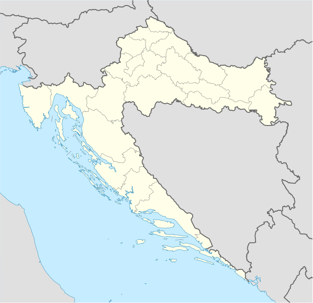
Deutsch: Positionskarte von Kroatien

Quadratische Plattkarte, N-S-Streckung 140 %. Geographische Begrenzung der Karte:

  • N: 46.8° N
  • S: 42.1° N
  • W: 13.1° O
  • O: 19.9° O
English: Location map of Croatia

Equirectangular projection, N/S stretching 140 %. Geographic limits of the map:

  • N: 46.8° N
  • S: 42.1° N
  • W: 13.1° E
  • E: 19.9° E
Date
Source own work, using United States National Imagery and Mapping Agency data
Author NordNordWest
Other versions

Derivative works of this file:

Kartenwerkstatt
This map has been made or improved in the German Kartenwerkstatt (Map Lab). You can propose maps to improve as well.

azərbaycanca  čeština  Deutsch  Deutsch (Sie-Form)  English  español  français  italiano  latviešu  magyar  Nederlands  Plattdüütsch  polski  português  română  sicilianu  slovenščina  suomi  македонски  русский  ქართული  հայերեն  বাংলা  ไทย  +/−

Licensing

I, the copyright holder of this work, hereby publish it under the following licenses:
GNU head Permission is granted to copy, distribute and/or modify this document under the terms of the GNU Free Documentation License, Version 1.2 or any later version published by the Free Software Foundation; with no Invariant Sections, no Front-Cover Texts, and no Back-Cover Texts. A copy of the license is included in the section entitled GNU Free Documentation License.
w:en:Creative Commons
attribution share alike
This file is licensed under the Creative Commons Attribution-Share Alike 3.0 Unported license.
You are free:
  • to share – to copy, distribute and transmit the work
  • to remix – to adapt the work
  • Under the following conditions:
    You may select the license of your choice.

    Captions

    Map of Croatia with defined county borders

    Items portrayed in this file

    depicts

    some value

    author name string: NordNordWest

    16 July 2008

    image/svg+xml

    6639d3a764888eca970e8dd3d89bd54b7ff4e742

    491,312 byte

    1,062 pixel

    1,097 pixel

    File history


    Click on a date/time to view the file as it appeared at that time.
    Date/TimeThumbnailDimensionsUserComment
    current08:00, 29 August 2008Thumbnail for version as of 08:00, 29 August 20081,097 × 1,062 (480 KB)NordNordWest
    15:54, 30 July 2008Thumbnail for version as of 15:54, 30 July 2008548 × 531 (412 KB)NordNordWestmore detailed borderlines
    16:55, 16 July 2008Thumbnail for version as of 16:55, 16 July 2008548 × 531 (454 KB)NordNordWest{{Information |Description= {{de|Positionskarte von Kroatien}} Quadratische Plattkarte, N-S-Streckung 140 %. Geographische Begrenzung der Karte: * N: 46.8° N * S: 42.1° N * W: 13.1° O * O: 19.9° O {{en|Location map of [[:en:Croatia|Cr


    More than 100 pages use this file. The following list shows the first 100 pages that use this file only. A full list is available.

    2000 European Men's Handball Championship

    Bakar, Croatia

    Battle of Lissa (1866)

    Belišće

    Bjelovar

    Bol, Croatia

    Borovo, Croatia

    Brač

    Buje

    Buzet

    Cerna, Croatia

    Cetingrad

    Cres

    Crikvenica

    Croatia national football team

    Croatian Radiotelevision

    Daruvar

    Diocletian's Palace

    Dubrovnik

    Goli Otok

    Gospić

    Karlovac

    Knin

    Komiža

    Koprivnica

    Kornati

    Krapina

    Križ, Zagreb County

    Križevci

    Krka National Park

    Kumrovec

    Lovrijenac

    Makarska

    Metković

    Mljet

    Mursko Središće

    Nadin, Croatia

    Našice

    Nedelišće

    Nin, Croatia

    Nova Gradiška

    Novi Marof

    Ogulin

    Opatija

    Operation Storm

    Osijek

    Otavice, Croatia

    Otok, Vukovar-Syrmia County

    Pag (town)

    Paklenica

    Pazin

    Plitvice Lakes National Park

    Ploče

    Podgora, Split-Dalmatia County

    Poreč

    Posedarje

    Požega, Croatia

    Prelog, Croatia

    Pula Arena

    Rijeka

    Rovinj

    Roč

    Rudina, Croatia

    Salona

    Samobor

    Senj

    Sinj

    Sisak

    Skradin

    Slatina, Croatia

    Slavonski Brod

    Smiljan, Croatia

    Solin

    Stara Gradiška

    Stari Jankovci

    Ston

    Sukošan

    Sućuraj

    Sveta Nedjelja, Hvar

    Trakošćan Castle

    Trogir

    Tvrđa

    Umag

    Valpovo

    Varaždin

    Velika Gorica

    Vinkovci

    Virovitica

    Vis (town)

    Višnjan

    Vodice, Croatia

    Vrbovsko

    Vrlika

    Vukovar

    Zadar

    Zaprešić

    Čakovec

    Đakovo

    Šenkovec

    Šibenik


    View more links to this file.

    Global file usage


    The following other wikis use this file:

    Usage on ab.wikipedia.org

    Ашаблон:Location map

    Ашаблон:Location map/doc

    Амодуль:Location map/data/Croatia

    Амодуль:Location map/data/Croatia/doc


    Usage on af.wikipedia.org

    Sjabloon:Liggingkaart Kroasië

    Donja Pušća


    Usage on als.wikipedia.org

    Vorlage:Infobox Ort in Kroatien

    Vorlage:Positionskarte Kroatien

    Zagreb


    Usage on am.wikipedia.org

    :Location map/doc


    :Location map 


    Usage on an.wikipedia.org

    Zagreb

    Observatorio de Višnjan

    Chadra

    Split

    Ragusa

    Parenzo

    Plantilla:Mapa de localización Croacia

    Šibenik

    Centro de Baloncesto Dražen Petrović

    Buje

    Buzet

    Rovinj


    Usage on ar.wikipedia.org

    قالب:خريطة مواقع

    قالب:خريطة مواقع كرواتيا

    قالب:خريطة مواقع/شرح

    بطولة أوروبا لكرة الصالات 2012

    قالب:خريطة مواقع/ملعب

    قالب:Location map/sandbox quick/doc

    وحدة:Location map/data/Croatia

    وحدة:Location map/data/Croatia/شرح

    اشتباك باكراتش

    حادثة بحيرات بليتفيتش

    معركة بوروفو سيلو

    حصار كييفو (1991)

    عملية العاصفة (حرب البوسنة والهرسك)


    Usage on arz.wikipedia.org

    قالب:Location map Croatia

    راكيتوڤيكا


    Usage on ast.wikipedia.org

    Zagreb

    Rijeka

    Krk

    Požega

    Universidá Juraj Dobrila de Pula

    Observatoriu de Višnjan

    Smiljan

    Split

    Dubrovnik

    Bancu Nacional de Croacia

    Módulu:Mapa de llocalización/datos/Croacia


    View more global usage of this file.

    Metadata

    This file contains additional information, probably added from the digital camera or scanner used to create or digitize it.

    If the file has been modified from its original state, some details may not fully reflect the modified file.


    Retrieved from "https://en.wikipedia.org/wiki/File:Croatia_location_map.svg"


    Languages


    This page is not available in other languages.
     

    Wikipedia


    Privacy policy

    About Wikipedia

    Disclaimers

    Contact Wikipedia

    Code of Conduct

    Developers

    Statistics

    Cookie statement

    Terms of Use

    Desktop