Home  

Random  

Nearby  


Log in  


Settings  


Donate  


About Wikipedia  

Disclaimers  


Wikipedia


File:Denmark physical map.svg


File  

Talk  


Language  

Watch  


File

File history

File usage

Global file usage

Metadata
File:Denmark physical map.svg
Size of this PNG preview of this SVG file: 704 × 600 pixels. Other resolutions: 282 × 240 pixels | 564 × 480 pixels | 902 × 768 pixels | 1,202 × 1,024 pixels | 2,404 × 2,048 pixels | 851 × 725 pixels.

Original file(SVG file, nominally 851 × 725 pixels, file size: 379 KB)


Summary

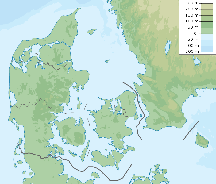
Description Denmark physical map, parameters equal to File:Denmark location map.svg
Date
Source Own work
Author Urutseg

Licensing

I, the copyright holder of this work, hereby publish it under the following license:
Creative Commons CC-Zero This file is made available under the Creative Commons CC0 1.0 Universal Public Domain Dedication.
The person who associated a work with this deed has dedicated the work to the public domain by waiving all of their rights to the work worldwide under copyright law, including all related and neighboring rights, to the extent allowed by law. You can copy, modify, distribute and perform the work, even for commercial purposes, all without asking permission.

Captions

Denmark physical map

Items portrayed in this file

depicts

some value

15 March 2011

image/svg+xml

File history


Click on a date/time to view the file as it appeared at that time.
Date/TimeThumbnailDimensionsUserComment
current15:29, 25 November 2022Thumbnail for version as of 15:29, 25 November 2022851 × 725 (379 KB)GrandEscogriffemore correct north-south stretching
20:51, 23 October 2013Thumbnail for version as of 20:51, 23 October 2013851 × 686 (300 KB)NordNordWestupd
05:50, 16 March 2011Thumbnail for version as of 05:50, 16 March 2011852 × 689 (302 KB)Urutseg


More than 100 pages use this file. The following list shows the first 100 pages that use this file only. A full list is available.

Aalborg

Aarhus

Aarhus (river)

Aborrebjerg

Agri Bavnehøj

Allied Forces Baltic Approaches

Arreskov Lake

Arresø

Bagå Formation

Bolbro Hill

Borremose

Brabrand Lake

Brøndbyøster

Bølling Lake

Copenhagen

Crowne Plaza Copenhagen Challenge

Danish Open (golf)

Danish PGA Championship

ECCO Tour Championship

Egå Engsø

Ejer Bavnehøj

Farum Lake

Frøbjerg Bavnehøj

Gammelmose

Gentofte Lake

Grønhøj

Gundestrup cauldron

Hammersø

Hasle Formation

Havneby

Havredal

Helgenæs

Herning Airport

Hestehave Wood

Himmelbjerget

Himmerland Open

Hjarnø

Hjørring

Hvidovre

Ise Fjord

Jelling stones

Jydegaard Formation

Kilen (lake)

Kolindsund

Kongernes Nordsjælland

Kronborg

Lake Bagsværd

Lake Esrum

Lake Stubbe

Lille Vildmose

List of Nike missile sites

List of national parks of Denmark

List of offshore wind farms in Denmark

Lysgård

Made in Denmark

Made in Denmark Challenge

Madum Lake

Mols

Mols Bjerge National Park

Mossø

Møllehøj

NATO Integrated Air Defense System

Nordic Open

Norsminde Fjord

Nusrat Djahan Mosque

Ole Rømer Observatory

Outline of the Danish Armed Forces at the end of the Cold War

Par force hunting landscape in North Zealand

Partnair Flight 394

Rabekke Formation

Robbedale Formation

Royal Danish Navy

Rytterknægten

Rønne Formation

Scandinavian Golf Club

Scandinavian Seniors Open

Shipco Masters

Skamlingsbanken

Snoghøj

Sortedam Lake

Sorthat Formation

Stabelhøje

Stevns Klint

Stilling-Solbjerg Lake

Storstrømmen

Structure of the Royal Danish Army

Svendborgsund

Sømosen

Tangeværket Dam

Thomas Bjørn Open

Thy National Park

Tirslund Rock

Trehøje Mols

Tystrup Sø

Vesthimmerland Airfield

Værløse Air Base

Yding Skovhøj

Æbelø

Ølstykke Municipality

Østervold Observatory


View more links to this file.

Global file usage


The following other wikis use this file:

Usage on als.wikipedia.org

Vorlage:Positionskarte Dänemark


Usage on ar.wikipedia.org

قالب:خريطة مواقع الدنمارك


Usage on ast.wikipedia.org

Módulu:Mapa de llocalización/datos/Dinamarca

Xeografía de Dinamarca

Módulu:Mapa de llocalización/datos/Dinamarca/usu


Usage on azb.wikipedia.org

کوپنهاقن


Usage on az.wikipedia.org

Luytla-Duymun

Streymoy

Şablon:Yer xəritəsi Danimarka

Yutlandiya

Böyük Kəmər

Skagerrak

Kattegat

Kiçik Kəmər

Zelandiya (ada)

Fyun

Vensyossel-Ti

Limfyord boğazı

Amager çimərliyi

Anholt adası

Boqe adası

Samsyo adası

Myon adası

Oryo adası

Femyo adası

Feyyo adası

Boroy adası

Kalsoy adası

Kunoy adası

Koltur adası

Skuvoy adası

Suvuroy adası

Hestur adası

Esturoy adası

Qoashyolmur adası

Tindhyolmur adası

Sandoy adası

Stoura-Duymun adası

Voar adası

Nyolsoy adası

Svuynoy adası

Viyoy adası

Miçines adası

Sumbiarstaynur

Franklin adası (Qrenlandiya)

Fuqloy adası

Qrenen burnu

Danimarka boğazları

Bornholm

Saltholm


View more global usage of this file.

Metadata

This file contains additional information, probably added from the digital camera or scanner used to create or digitize it.

If the file has been modified from its original state, some details may not fully reflect the modified file.


Retrieved from "https://en.wikipedia.org/wiki/File:Denmark_physical_map.svg"


Languages


This page is not available in other languages.
 

Wikipedia


Privacy policy

About Wikipedia

Disclaimers

Contact Wikipedia

Code of Conduct

Developers

Statistics

Cookie statement

Terms of Use

Desktop