Home  

Random  

Nearby  


Log in  


Settings  


Donate  


About Wikipedia  

Disclaimers  


Wikipedia


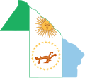
File:Flag-map of Chaco Province.svg


File  

Talk  


Language  

Watch  


File

File history

File usage

Metadata
File:Flag-map of Chaco Province.svg
Size of this PNG preview of this SVG file: 512 × 461 pixels. Other resolutions: 267 × 240 pixels | 533 × 480 pixels | 853 × 768 pixels | 1,137 × 1,024 pixels | 2,275 × 2,048 pixels.

Original file(SVG file, nominally 512 × 461 pixels, file size: 58 KB)


Summary

Description
English: Flag map of Chaco
Date
Source Own work
Author Lucash

Licensing

I, the copyright holder of this work, hereby publish it under the following license:
w:en:Creative Commons
attribution share alike
This file is licensed under the Creative Commons Attribution-Share Alike 3.0 Unported license.
You are free:
  • to share – to copy, distribute and transmit the work
  • to remix – to adapt the work
  • Under the following conditions:


    Captions

    Add a one-line explanation of what this file represents

    Items portrayed in this file

    depicts

    some value

    12 May 2013

    File history


    Click on a date/time to view the file as it appeared at that time.
    Date/TimeThumbnailDimensionsUserComment
    current09:36, 6 October 2023Thumbnail for version as of 09:36, 6 October 2023512 × 461 (58 KB)Goldszternupdate
    14:01, 12 May 2013Thumbnail for version as of 14:01, 12 May 2013659 × 600 (78 KB)LucashUser created page with UploadWizard


    More than 100 pages use this file. The following list shows the first 100 pages that use this file only. A full list is available.

    Almirante Brown Department

    Aviá Teraí

    Barranqueras

    Basail

    Bermejo Department, Chaco

    Capitán Solari

    Chacabuco Department, Chaco

    Chaco National Park

    Charadai

    Charata

    Chorotis

    Ciervo Petiso

    Colonia Aborigen Chaco

    Colonia Aborigen El Pastoril

    Colonia Baranda

    Colonia Benítez

    Colonia Elisa

    Colonia Popular

    Colonias Unidas

    Comandancia Frías

    Comandante Fernández Department

    Comandante Fontana, Chaco

    Concepción del Bermejo

    Coronel Du Graty

    Corzuela

    Cote Lai

    Doce de Octubre Department

    Dos de Abril Department

    El Espinillo, Chaco

    El Paranacito

    El Sauzal, Chaco

    El Sauzalito

    El Tacuruzal

    Enrique Urién

    Estación General Obligado

    Fortín Belgrano

    Fortín Las Chuñas

    Fortín Lavalle

    Fray Justo Santa María de Oro Department

    Fuerte Esperanza

    Gancedo

    General Belgrano Department, Chaco

    General Capdevila

    General Donovan Department

    General Güemes Department, Chaco

    General José de San Martín, Chaco

    General Pinedo, Chaco

    General Vedia

    Haumonia

    Hermoso Campo

    Horquilla, Chaco

    Independencia Department, Chaco

    Ingeniero Barbet

    Isla del Cerrito

    Itín, Chaco

    La Chiquita

    La Clotilde, Chaco

    La Eduvigis

    La Leonesa

    La Leonesa, Chaco

    La Liguria

    La Sabana

    La Verde

    La Vicuña

    Laguna Blanca, Chaco

    Lapachito

    Las Breñas

    Las Palmas, Argentina

    Libertad Department, Chaco

    Libertador General San Martín Department, Chaco

    Machagai

    Maipú Department, Chaco

    Makallé

    Margarita Belén

    Mayor Luis Jorge Fontana Department

    Nueve de Julio Department, Chaco

    O'Higgins Department

    Palometa River

    Pampa del Infierno

    Paraná Miní River

    Presidencia Roque Sáenz Peña

    Presidencia de la Plaza

    Presidencia de la Plaza Department

    Primero de Mayo Department

    Puerto Tirol

    Quitilipi

    Quitilipi Department

    Río Negro (Chaco Province)

    Río de Oro (Argentina)

    San Bernardo, Chaco

    San Fernando Department

    San Lorenzo Department, Chaco

    Santa Sylvina

    Sargento Cabral Department

    Tapenagá Department

    Tapenagá River

    Teuquito River

    Tres Isletas

    Veinticinco de Mayo Department, Chaco

    Villa Berthet


    View more links to this file.

    Metadata

    This file contains additional information, probably added from the digital camera or scanner used to create or digitize it.

    If the file has been modified from its original state, some details may not fully reflect the modified file.


    Retrieved from "https://en.wikipedia.org/wiki/File:Flag-map_of_Chaco_Province.svg"


    Languages


    This page is not available in other languages.
     

    Wikipedia


    Privacy policy

    About Wikipedia

    Disclaimers

    Contact Wikipedia

    Code of Conduct

    Developers

    Statistics

    Cookie statement

    Terms of Use

    Desktop