Home  

Random  

Nearby  


Log in  


Settings  


Donate  


About Wikipedia  

Disclaimers  


Wikipedia


File:Guatemala location map.svg


File  

Talk  


Language  

Watch  


File

File history

File usage

Global file usage

Metadata
File:Guatemala location map.svg
Size of this PNG preview of this SVG file: 545 × 599 pixels. Other resolutions: 218 × 240 pixels | 436 × 480 pixels | 698 × 768 pixels | 931 × 1,024 pixels | 1,862 × 2,048 pixels | 982 × 1,080 pixels.

Original file(SVG file, nominally 982 × 1,080 pixels, file size: 120 KB)


Summary

Description
Deutsch: Positionskarte von Guatemala

Quadratische Plattkarte

Русский: Карта расположения Гватемалы
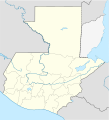
English: Location map of Guatemala

Equirectangular projection, Geographic limits of the map:

  • N: 18.05° N
  • S: 13.54° N
  • W: 92.34° W
  • E: 88.07° W
Հայերեն: Գվատեմալայի տեղորոշման քարտեզ

Ուղղանկյուն պրոյեկցիա։ Քարտեզում աշխարհագրական սահմանները.

  • Հյուսիս: 18.05° հս.լ.
  • Հարավ: 13.54° հս.լ
  • Արևմուտք: 92.34° ամ.ե.
  • Արևելք: 88.07° ամ.ե.
Date
Source
Author
SVG development

InfoField

 
The source code of this SVGisinvalid due to 6 errors.
 
This W3C-invalid vector image was created with Adobe Illustrator,
 
and with Inkscape.
This is a retouched picture, which means that it has been digitally altered from its original version. Modifications: Optimized objects, added rivers. The original can be viewed here: Mexico location map.svg. Modifications made by Spischot.

Licensing

w:en:Creative Commons
attribution share alike
This file is licensed under the Creative Commons Attribution-Share Alike 3.0 Unported license.
You are free:
  • to share – to copy, distribute and transmit the work
  • to remix – to adapt the work
  • Under the following conditions:

    Original upload log

    This image is a derivative work of the following images:

    Uploaded with derivativeFX

    Captions

    Add a one-line explanation of what this file represents

    Items portrayed in this file

    depicts

    26 October 2009

    File history


    Click on a date/time to view the file as it appeared at that time.
    Date/TimeThumbnailDimensionsUserComment
    current19:11, 18 October 2022Thumbnail for version as of 19:11, 18 October 2022982 × 1,080 (120 KB)JanitoalevicFixing
    18:59, 18 October 2022Thumbnail for version as of 18:59, 18 October 2022982 × 1,080 (102 KB)JanitoalevicAdded disputed territory
    21:05, 26 October 2009Thumbnail for version as of 21:05, 26 October 2009982 × 1,080 (154 KB)Spischot{{Information |Description={{de|Positionskarte von Guatemala}} Quadratische Plattkarte {{en|Location map of Guatemala}} Equirectangular projection, Geographic limits of the map: * N: 18.05° N * S: 13.54° N * W: 9


    More than 100 pages use this file. The following list shows the first 100 pages that use this file only. A full list is available.

    Acatenango, Chimaltenango

    Aguacatán

    Alotenango

    Antigua Guatemala

    Camotán

    Canillá

    Casillas, Guatemala

    Chajul

    Chiantla

    Chicamán

    Chichicastenango

    Chiché, Guatemala

    Chimaltenango

    Chiquimula

    Chisec

    Ciudad Vieja

    Cobán

    Colotenango

    Concepción Huista

    Cuilapa

    Cuilco

    Cunén

    Dos Erres massacre

    El Tejar, Chimaltenango

    Escuintla

    Esquipulas

    Flores, Petén

    Fray Bartolomé de las Casas

    Guastatoya

    Guatemala City

    Guazacapán

    Huehuetenango

    Ipala, Guatemala

    Jacaltenango

    Jalapa, Jalapa

    Jocotenango

    Jocotán

    Joyabaj

    Jutiapa

    La Aurora International Airport

    Livingston, Guatemala

    Magdalena Milpas Altas

    Malacatancito

    Nentón

    Pachalum

    Panajachel

    Panzós

    Parramos

    Patzité

    Playa Grande, Guatemala

    Puerto Barrios

    Puerto Quetzal

    Puerto San José

    Quetzaltenango

    Qʼumarkaj

    Rabinal

    Retalhuleu

    Sacapulas

    Salamá

    San Agustín Lanquín

    San Andrés Sajcabajá

    San Antonio Huista

    San Antonio Ilotenango

    San Bartolomé Jocotenango

    San Bartolomé Milpas Altas

    San Cristóbal Verapaz

    San Diego, Zacapa

    San Ildefonso Ixtahuacán

    San Juan Chamelco

    San Juan Comalapa

    San Juan Cotzal

    San Juan Ixcoy

    San Juan La Laguna

    San Lucas Sacatepéquez

    San Marcos, Guatemala

    San Mateo Ixtatán

    San Miguel Acatán

    San Pedro Carchá

    San Pedro Jocopilas

    San Pedro Necta

    San Pedro Soloma

    Santa Cruz Verapaz

    Santa Cruz del Quiché

    Santa Lucía Milpas Altas

    Santa Maria Nebaj

    Santa María de Jesús

    Santiago Chimaltenango

    Santiago Sacatepéquez

    Santo Domingo Xenacoj

    Senahú

    Sipacate

    Sololá

    Sumpango, Sacatepéquez

    Tactic, Guatemala

    Tamahú

    Teculután

    Todos Santos Cuchumatán

    Tucurú

    Uspantán

    Usumatlán


    View more links to this file.

    Global file usage


    The following other wikis use this file:

    Usage on af.wikipedia.org

    Sjabloon:Liggingkaart Guatemala

    Tikal

    Quiriguá

    Santa María (vulkaan)


    Usage on an.wikipedia.org

    Ciudat de Guatemala

    Plantilla:Mapa de localización Guatemala


    Usage on ar.wikipedia.org

    قالب:خريطة مواقع غواتيمالا


    Usage on ast.wikipedia.org

    Puerto San José

    San Pedro Sacatepéquez (Guatemala)

    Ciudá de Guatemala

    Volcán Santa María

    Volcán de Fueu

    Módulu:Mapa de llocalización/datos/Guatemala/usu

    Uaxactún

    Terremotu de Guatemala de 1902

    Campusantu de la Ciudá de Guatemala

    Aeropuertu Bananera

    Aeropuertu de Coatepeque

    Aeropuertu de Cobán

    Aeropuertu de Huehuetenango

    Aeropuertu de Playa Grande

    Aeropuertu de Puerto Barrio

    Aeropuertu de Puerto San José

    Aeropuertu de Quetzaltenango

    Aeropuertu de Quiché

    Aeropuertu de Retalhuleu

    Puerto Barrio

    Puertu Quetzal

    Santo Tomás de Castilla

    Plantía:Mapa de llocalización de Guatemala

    Volcán San Pedro (Guatemala)


    Usage on az.wikipedia.org

    Qvatemala (şəhər)

    Tikal

    Şablon:Yer xəritəsi Qvatemala


    Usage on bar.wikipedia.org

    Vorlog:Guatemala, Peten-Region

    Vorlog:Positionskarte Guatemala


    Usage on ba.wikipedia.org

    Ҡалып:ПозКарта Гватемала


    Usage on be-tarask.wikipedia.org

    Гватэмала (горад)

    Шаблён:Лякалізацыйная мапа Гватэмалы


    Usage on be.wikipedia.org

    Гватэмала (горад)

    Шаблон:На карце/Гватэмала

    Эскуінтла (Гватэмала)

    Кесальтэнанга

    Сан-Маркас (Гватэмала)


    Usage on bg.wikipedia.org

    Шаблон:ПК Гватемала


    Usage on bn.wikipedia.org

    ি      ি  ি

    ি: ি//

    ি: ি///ি


    Usage on bs.wikipedia.org

    Šablon:Lokacijska karta Gvatemala


    Usage on ca.wikipedia.org

    Cancuén


    View more global usage of this file.

    Metadata

    This file contains additional information, probably added from the digital camera or scanner used to create or digitize it.

    If the file has been modified from its original state, some details may not fully reflect the modified file.


    Retrieved from "https://en.wikipedia.org/wiki/File:Guatemala_location_map.svg"


    Languages


    This page is not available in other languages.
     

    Wikipedia


    Privacy policy

    About Wikipedia

    Disclaimers

    Contact Wikipedia

    Code of Conduct

    Developers

    Statistics

    Cookie statement

    Terms of Use

    Desktop