Home  

Random  

Nearby  


Log in  


Settings  


Donate  


About Wikipedia  

Disclaimers  


Wikipedia


File:India Haryana location map.svg


File  

Talk  


Language  

Watch  


File

File history

File usage

Global file usage

Metadata
File:India Haryana location map.svg
Size of this PNG preview of this SVG file: 563 × 599 pixels. Other resolutions: 226 × 240 pixels | 451 × 480 pixels | 722 × 768 pixels | 962 × 1,024 pixels | 1,925 × 2,048 pixels | 845 × 899 pixels.

Original file(SVG file, nominally 845 × 899 pixels, file size: 253 KB)


Summary

Description

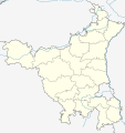
Location map of Haryana Geographic limits of the map:

  • 31.01°N
  • 27.59°N
  • 74.39°E
  • 77.61°E
Date
Source
Author

Licensing

w:en:Creative Commons
attribution share alike
This file is licensed under the Creative Commons Attribution-Share Alike 3.0 Unported license.
You are free:
  • to share – to copy, distribute and transmit the work
  • to remix – to adapt the work
  • Under the following conditions:

    Captions

    Map of Haryana

    Items portrayed in this file

    depicts

    27 May 2013

    image/svg+xml

    File history


    Click on a date/time to view the file as it appeared at that time.
    Date/TimeThumbnailDimensionsUserComment
    current17:46, 28 April 2023Thumbnail for version as of 17:46, 28 April 2023845 × 899 (253 KB)C1MMFixed districts
    04:53, 13 August 2021Thumbnail for version as of 04:53, 13 August 2021845 × 899 (213 KB)C1MMc bounds
    05:16, 25 October 2020Thumbnail for version as of 05:16, 25 October 2020626 × 750 (381 KB)C1MMUpdated districts
    17:47, 24 October 2020Thumbnail for version as of 17:47, 24 October 2020626 × 750 (373 KB)C1MMAdded new district
    04:09, 11 June 2016Thumbnail for version as of 04:09, 11 June 2016626 × 750 (373 KB)Milenioscurorivers
    05:28, 27 May 2013Thumbnail for version as of 05:28, 27 May 2013954 × 1,188 (92 KB)Milenioscuro{{Information |Description ={{en|1=India_Haryana_location_map}} {{es|1=India_Haryana_location_map}} |Source =File:Haryana locator map.svg |Author =User:Shadowxfox |Date =2013-05-26 |Permission = |other_versions...


    More than 100 pages use this file. The following list shows the first 100 pages that use this file only. A full list is available.

    Agroha (town)

    Ambala

    Ambala Cantonment

    Ambala Sadar

    Asan Khurd

    Assandh

    Ateli

    Babiyal

    Bahadurgarh

    Ballabhgarh

    Banbhori

    Barara

    Bawal

    Bawani Khera

    Beri, Jhajjar

    Bhiwani

    Bhoda Hoshnak

    Buria

    Charkhi Dadri

    Cheeka

    Chhachhrauli

    Dharuhera

    Dundahera

    Ellenabad

    Farakhpur

    Faridabad

    Farrukhnagar

    Ganaur

    Gharaunda

    Ghasola

    Gohana

    Gonder, Haryana

    Gurgaon

    Gurgaon Rural

    Haileymandi

    Hansi

    Hassanpur

    Hathin

    Hisar (city)

    Hodal

    Jagadhri

    Jakhal Mandi

    Jhajjar

    Jind

    Kaithal

    Kalanwali

    Kalayat

    Kalesar National Park

    Kalka

    Kansapur, Yamunanagar

    Kansepur

    Kardhan

    Karnal

    Kurukshetra

    Ladrawan

    Ladwa

    Loharu

    Maham

    Mahendragarh

    Mandi Dabwali

    Nadana

    Nalwa

    Naraingarh

    Narnaul

    Narnaund

    Narwana

    Nilokheri

    Palwal

    Panchkula

    Panipat

    Panipat Taraf Ansar

    Panipat Taraf Rajputan

    Pataudi

    Pehowa

    Pinjore

    Punahana

    Pundri

    Radaur

    Raipur Rani

    Ratia

    Rewari

    Rewari (Rural)

    Sadaura

    Safidon

    Samalkha

    Sankhol

    Saraswati Nagar

    Sasauli

    Shahabad Markanda

    Sirsa

    Siwani

    Sohna

    Sonipat

    Sukhrali

    Sultanpur National Park

    Taoru

    Taraori

    Thanesar

    Tilpat

    Tohana


    View more links to this file.

    Global file usage


    The following other wikis use this file:

    Usage on azb.wikipedia.org

    سونیپات

    جارلی

    فولان (هیندوستان)

    فالقو تیرت

    سارسود

    سارسا, بیوانی

    سارولا

    سارال, بیوانی

    سانقرولی

    ماسودپور

    ماستاپور

    ماسانی

    کالالی, بیوانی

    ساماسپور ماجرا

    کاکرولی ساردارا

    کاکرولی هوکمی

    کاکرولی هاتی

    سالهاواس

    سالهاواس, رواری

    کاکاوت

    کایمری, حیصار

    کایملا

    مانسارباس

    سای, بیوانی

    ساهاروا

    ساهارانواس

    سادهانواس

    مانقواکی

    مانقرا

    کابلانا

    مانقار بانی

    مانقالی

    مانتی (هیندوستان)

    مانسار

    روجهوواس

    روهرای

    روهنات

    ماندوتی

    ریواسا

    جوندلا

    جوی خورد

    رواری خرا

    رواری خرا, بیوانی

    رواری بلوک اوف رواری دیستریکت

    ماندهولی خورد

    ماندهانا, بیوانی

    جوری, قوروقرام

    جونیاواس

    رهرودهی

    جیتپور ایستامرار


    View more global usage of this file.

    Metadata

    This file contains additional information, probably added from the digital camera or scanner used to create or digitize it.

    If the file has been modified from its original state, some details may not fully reflect the modified file.


    Retrieved from "https://en.wikipedia.org/wiki/File:India_Haryana_location_map.svg"


    Languages


    This page is not available in other languages.
     

    Wikipedia


    Privacy policy

    About Wikipedia

    Disclaimers

    Contact Wikipedia

    Code of Conduct

    Developers

    Statistics

    Cookie statement

    Terms of Use

    Desktop