Home  

Random  

Nearby  


Log in  


Settings  


Donate  


About Wikipedia  

Disclaimers  


Wikipedia


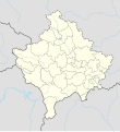
File:Kosovo adm location map.svg


File  

Talk  


Language  

Watch  


File

File history

File usage

Global file usage

Metadata
File:Kosovo adm location map.svg
Size of this PNG preview of this SVG file: 548 × 599 pixels. Other resolutions: 219 × 240 pixels | 439 × 480 pixels | 702 × 768 pixels | 936 × 1,024 pixels | 1,873 × 2,048 pixels | 1,014 × 1,109 pixels.

Original file(SVG file, nominally 1,014 × 1,109 pixels, file size: 185 KB)


Summary

Description
Deutsch: Positionskarte des Kosovo
English: Location map of Kosovo

Equirectangular projection, vertical stretching 135 %
Border coordinates

43.3
19.8←↕→21.9
41.7
 Info This map is part of a series of location maps with unified standards: SVG as file format, standardised colours and name scheme. The boundaries on these maps always show the de facto situation and do not imply any endorsement or acceptance. In case of changes of the shown area the file is updated. The old version will be uploaded as a new file and thus is still available.
Date
Source

Own work using:

  • United States National Imagery and Mapping Agency data
Author NordNordWest
Other versions
SVG development

InfoField

 
The SVG code is valid.
 
This map was created with Adobe Illustrator.

Kartenwerkstatt
This SVG map has been made or improved in the German Kartenwerkstatt (Map Lab). You can propose maps to improve as well.

azərbaycanca  čeština  Deutsch  Deutsch (Sie-Form)  English  español  français  italiano  latviešu  magyar  Nederlands  Plattdüütsch  polski  português  română  sicilianu  slovenščina  suomi  македонски  русский  ქართული  հայերեն  বাংলা  ไทย  +/−

Licensing

Usage of this file with:

Map: NordNordWest, Licence: Creative Commons by-sa-3.0 de

explanatory notes: Legally binding is only the full legalcode. For a free usage I recommend to respect the following licence conditions:
1. Provide my name as given above: NordNordWest,
2. a copy of, or the URI for, the applicable license: https://creativecommons.org/licenses/by-sa/3.0/de/legalcode,
3. the title of the work,
4. in the case of an adaptation, a credit identifying the use of the work in the adaptation.
This license and the rights granted hereunder will terminate automatically upon any breach by you of the terms of this license. Any of the above conditions can be waived if you get permission from the copyright holder. If you have questions or wish differing conditions, please contact me through nnwest@t-online.deormy discussion page

w:en:Creative Commons
attribution share alike
This file is licensed under the Creative Commons Attribution-Share Alike 3.0 Germany license.
Attribution: Karte: NordNordWest, Lizenz: Creative Commons by-sa-3.0 de
You are free:
  • to share – to copy, distribute and transmit the work
  • to remix – to adapt the work
  • Under the following conditions:

    Captions

    Add a one-line explanation of what this file represents

    Items portrayed in this file

    depicts

    12 January 2018

    File history


    Click on a date/time to view the file as it appeared at that time.
    Date/TimeThumbnailDimensionsUserComment
    current18:29, 17 March 2020Thumbnail for version as of 18:29, 17 March 20201,014 × 1,109 (185 KB)NordNordWestReverted to version as of 13:31, 16 March 2018 (UTC), not without a discussion
    12:15, 17 March 2020Thumbnail for version as of 12:15, 17 March 2020512 × 560 (119 KB)ZvuqnikiReverted to version as of 13:09, 16 March 2018 (UTC)
    12:12, 17 March 2020Thumbnail for version as of 12:12, 17 March 20201,014 × 1,109 (210 KB)ZvuqnikiThis map reflects the current reality regarding the border of Kosovo. Serbia has no authority over Kosovo, and there are police and military forces that all Kosovo borders.
    13:31, 16 March 2018Thumbnail for version as of 13:31, 16 March 20181,014 × 1,109 (185 KB)NordNordWestReverted to version as of 18:29, 12 January 2018 (UTC) Serbia still thinks that Kosovo is part of Serbia, so it stays with a dashed line
    13:09, 16 March 2018Thumbnail for version as of 13:09, 16 March 2018512 × 560 (119 KB)HakuliKosovo new map updatet. The dashlines are removed. The dashlines are used only when is shown a larger map.
    18:29, 12 January 2018Thumbnail for version as of 18:29, 12 January 20181,014 × 1,109 (185 KB)NordNordWest== {{int:filedesc}} == {{Information |Description= {{de|1=Positionskarte des Kosovo}} {{en|1=Location map of Kosovo}} {{Location map series N |stretching=135 |top=43.3 |bottom=41.7 |left=19.8 |right=21.9 }} |Source={{Own using}} * United States Nationa...


    More than 100 pages use this file. The following list shows the first 100 pages that use this file only. A full list is available.

    200708 Football Superleague of Kosovo

    200809 Football Superleague of Kosovo

    Bajgora

    Banjska (village)

    Battle of Košare

    Belo Brdo mine

    Berkovo

    Binač

    Blaçi

    Bllacë

    Boletin

    Brezovica, Kosovo

    Brod, Dragaš

    Buble, Kosovo

    Cerrca

    Church of St. Elijah, Podujevo

    Crepulje mine

    Crnac mine

    Desivojca

    Deçan

    Dragash

    Drazhnje mine

    Drenas

    Dresnik

    Dumosh-Batllava Airfield

    Football Superleague of Kosovo

    Gjakova

    Gjakova Airport

    Goraždevac

    Gračanica, Kosovo

    Hani i Elezit

    Istog

    Jarinje

    Jažince, Štrpce

    Junik

    Kabash

    Kamenica, Kosovo

    Kaçandoll

    Kaçanik

    Klina

    Klokot

    Koliq

    Komoran (village)

    Korishë (Prizren)

    Korroticë e Epërme

    Kosovo Basketball Superleague

    Kosovo Polje

    Krajkovë

    Kuqishtë

    Leposavić

    Lipjan

    Lipovica, Leposavić

    List of top-division football clubs in UEFA countries

    Malisheva

    Mamusha

    Mitrovica, Kosovo

    Monastery of the Holy Archangels

    Novo Brdo

    Obiliq

    Pakashticë

    Parteš

    Peja

    Polijane, Istog

    Požaranje

    Prapashticë

    Prilep, Kosovo

    Prilepnica

    Pristina International Airport

    Prizren

    Rahovec

    Ranilug

    Ratkovac, Orahovac

    Račak massacre

    Reçak

    Sfeçël

    Shalë, Vushtrri

    Shtime

    Skenderaj

    Skorobište

    Slatina Air Base

    Sllakovc

    Sport in Kosovo

    Sredska, Prizren

    Stanoc i Poshtëm

    Studençan

    Suva Reka

    Tučep

    Velekinca

    Velika Hoča

    Visoki Dečani

    Viti, Kosovo

    Vranidoll

    Zubin Potok

    Zupče

    Zuzaku

    Zvečan

    Çikatovë e Vjeter

    Čaglavica

    Štrpce

    Žač


    View more links to this file.

    Global file usage


    The following other wikis use this file:

    Usage on af.wikipedia.org

    Sjabloon:Liggingkaart Kosovo


    Usage on als.wikipedia.org

    Pristina

    Vorlage:Positionskarte Kosovo

    Vorlage:Infobox Ort im Kosovo


    Usage on an.wikipedia.org

    Plantilla:Mapa de localización Kosovo

    Pristina


    Usage on ar.wikipedia.org

    قالب:خريطة مواقع كوسوفو

    معركة قوصوه الثانية

    جائحة فيروس كورونا في كوسوفو

    جيرافيسا


    Usage on ast.wikipedia.org

    Cerrcë

    Prístina

    Módulu:Mapa de llocalización/datos/Kosovu

    Aeropuertu Internacional de Prístina

    Aeropuertu de Gjakova

    Base Aérea de Slatina

    Módulu:Mapa de llocalización/datos/Kosovu/usu


    Usage on az.wikipedia.org

    Priştina

    Prizren

    Şablon:Yer xəritəsi Kosovo

    Kosovo Milli Teatrı

    Klokot

    Müqəddəs Tereza Ana kilsəsi (Priştina)

    İmperatorluq Məscidi (Priştina)

    Brequ i Diellit (Priştina)

    Ferizovik

    Peç (Kosovo)

    Peçka-Banya

    Brezovisa


    Usage on ba.wikipedia.org

    Ҡалып:ПозКарта Косово Республикаһы


    Usage on be.wikipedia.org

    Белы Дрын

    Шаблон:На карце/Рэспубліка Косава

    Каньён Белага Дрына

    Аэрапорт Прышціны

    Джаковіца (аэрапорт)


    Usage on bg.wikipedia.org

    Шаблон:ПК Косово

    Национална библиотека на Косово


    Usage on bn.wikipedia.org

    ি: ি//

    ি: ি///ি


    Usage on bs.wikipedia.org

    Šablon:Lokacijska karta Kosovo

    Spisak gradova na Kosovu

    Gramočelj

    Babaloć

    Beleg

    Belaje

    Gornji Crnobreg

    Rugovska klisura

    Šablon:Infokutija naselje na Kosovu

    Šablon:Infokutija naselje na Kosovu/dok

    Planjane


    View more global usage of this file.

    Metadata

    This file contains additional information, probably added from the digital camera or scanner used to create or digitize it.

    If the file has been modified from its original state, some details may not fully reflect the modified file.


    Retrieved from "https://en.wikipedia.org/wiki/File:Kosovo_adm_location_map.svg"


    Languages


    This page is not available in other languages.
     

    Wikipedia


    Privacy policy

    About Wikipedia

    Disclaimers

    Contact Wikipedia

    Code of Conduct

    Developers

    Statistics

    Cookie statement

    Terms of Use

    Desktop