
Original file (SVG file, nominally 663 × 570 pixels, file size: 352 KB)
| This is a file from the Wikimedia Commons. Information from its description page there is shown below. Commons is a freely licensed media file repository. You can help. |
| This is a featured picture, which means that members of the community have identified it as one of the finest images on the English Wikipedia, adding significantly to its accompanying article. If you have a different image of similar quality, be sure to upload it using the proper free license tag, add it to a relevant article, and nominate it. |
| This image was selected as picture of the day on the English Wikipedia for September 15, 2014. |
|
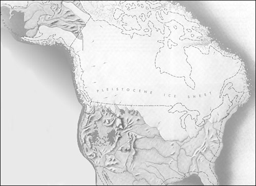
| DescriptionLake bonneville map.svg |
English: Pleistocene epoch map showing the extent of the Lake Bonneville Flood and Pleistocene lakes in northwestern United States around 14.5000 radiocarbon years (~17,500 calendar years) before present.
|
| Date | |
| Source |
Own work.
W3C-validity not checked. |
| Author | Fallschirmjäger |
| Date/Time | Thumbnail | Dimensions | User | Comment | |
|---|---|---|---|---|---|
| current | 22:29, 11 September 2014 | | 663 × 570 (352 KB) | Liandrei | Fixed alignment |
| 22:27, 11 September 2014 |  | 663 × 570 (352 KB) | Liandrei | Removed ambiguous arrows from Lake Missoula and those pointing from the Sacramento River to Lake Lahontan per POTD/2014-09-15 discussion. | |
| 11:12, 21 April 2013 |  | 663 × 570 (352 KB) | Liandrei | Fixed Mexico | |
| 11:04, 21 April 2013 |  | 666 × 570 (320 KB) | Liandrei | Widened and moved boxes to left | |
| 22:52, 20 March 2013 |  | 650 × 570 (395 KB) | Liandrei | tiny tweak | |
| 01:27, 20 March 2013 |  | 650 × 570 (395 KB) | Liandrei | tweaks | |
| 01:21, 13 March 2013 |  | 650 × 570 (521 KB) | Liandrei | forgot to remove error from inkscape again... | |
| 01:19, 13 March 2013 |  | 650 × 570 (521 KB) | Liandrei | tweakage | |
| 01:09, 13 March 2013 |  | 650 × 570 (521 KB) | Liandrei | Added coastline & made valid svg | |
| 05:01, 12 March 2013 |  | 650 × 570 (396 KB) | Orionist | Fixed errors to validate SVG, removed white rectangles and cropped extraneous parts of the maps, reduced file size, and did some other cosmetic changes. |
This file contains additional information, probably added from the digital camera or scanner used to create or digitize it.
If the file has been modified from its original state, some details may not fully reflect the modified file.
| Width | 662.963px |
|---|---|
| Height | 569.977px |