Home  

Random  

Nearby  


Log in  


Settings  


Donate  


About Wikipedia  

Disclaimers  


Wikipedia


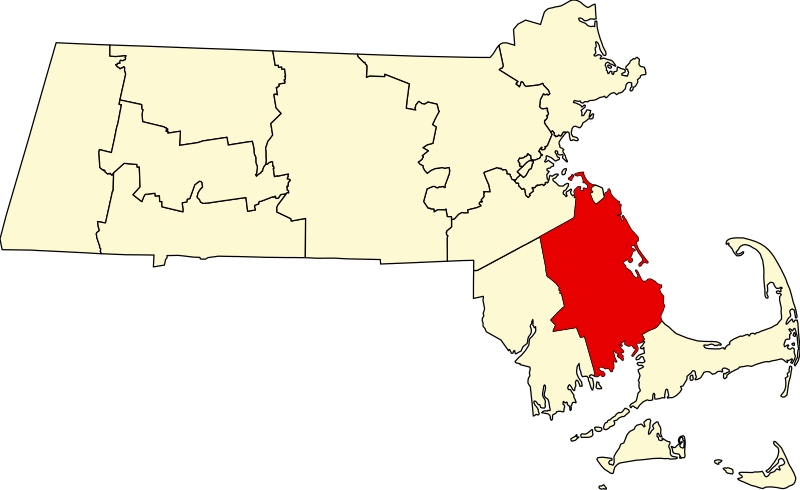
File:Map of Massachusetts highlighting Plymouth County.svg


File  

Talk  


Language  

Watch  


File

File history

File usage

Global file usage

Metadata
File:Map of Massachusetts highlighting Plymouth County.svg
Size of this PNG preview of this SVG file: 800 × 489 pixels. Other resolutions: 320 × 196 pixels | 640 × 391 pixels | 1,024 × 626 pixels | 1,280 × 783 pixels | 2,560 × 1,566 pixels | 1,488 × 910 pixels.

Original file(SVG file, nominally 1,488 × 910 pixels, file size: 26 KB)


Summary

Description
David Benbennick made this map. For more information, see Commons:United States county locator maps.
Date 12 February 2006 (original upload date)
Source No machine-readable source provided. Own work assumed (based on copyright claims).
Author No machine-readable author provided. David Benbennick assumed (based on copyright claims).

Licensing

Public domain I, the copyright holder of this work, release this work into the public domain. This applies worldwide.
In some countries this may not be legally possible; if so:
I grant anyone the right to use this work for any purpose, without any conditions, unless such conditions are required by law.

Captions

Add a one-line explanation of what this file represents

Items portrayed in this file

depicts

12 February 2006

image/svg+xml

File history


Click on a date/time to view the file as it appeared at that time.
Date/TimeThumbnailDimensionsUserComment
current21:43, 24 June 2024Thumbnail for version as of 21:43, 24 June 20241,488 × 910 (26 KB)Nuxfix rendering (remove clipping)
12:50, 12 February 2006Thumbnail for version as of 12:50, 12 February 20062,976 × 1,819 (43 KB)David Benbennick{{subst:User:Dbenbenn/clm|county=Plymouth County|state=Massachusetts|type=county}}


More than 100 pages use this file. The following list shows the first 100 pages that use this file only. A full list is available.

Abington, Massachusetts

Assawompset Pond

Bridgewater, Massachusetts

Bridgewater (CDP), Massachusetts

Brockton, Massachusetts

Button Island (Massachusetts)

Carver, Massachusetts

Cedar Pond (Massachusetts)

Cedarville, Massachusetts

Chiltonville, Massachusetts

Clark's Island

College Pond

Curlew Pond

Duxbury, Massachusetts

Duxbury (CDP), Massachusetts

East Bridgewater, Massachusetts

Eel River (Massachusetts)

Ellisville, Massachusetts

Great Herring Pond

Great Quittacas Pond

Green Harbor-Cedar Crest, Massachusetts

Halfway Pond

Halifax, Massachusetts

Hanover, Massachusetts

Hanson, Massachusetts

Hanson (CDP), Massachusetts

Hingham, Massachusetts

Hingham (CDP), Massachusetts

Holmes Reservation

Hull, Massachusetts

Jones River

Kingston, Massachusetts

Kingston (CDP), Massachusetts

Lake Nippenicket

Lakeville, Massachusetts

List of counties in Massachusetts

Little Pond (Massachusetts)

Little Quittacas Pond

Manomet, Massachusetts

Marion, Massachusetts

Marion Center, Massachusetts

Marshfield, Massachusetts

Marshfield (CDP), Massachusetts

Marshfield Hills, Massachusetts

Matfield River

Mattapoisett, Massachusetts

Mattapoisett Center, Massachusetts

Micajah Heights, Massachusetts

Micajah Pond (Massachusetts)

Middleborough, Massachusetts

Middleborough Center, Massachusetts

Monponsett Pond

Morton Park (Massachusetts)

National Register of Historic Places listings in Plymouth County, Massachusetts

Nemasket River

North Lakeville, Massachusetts

North Pembroke, Massachusetts

North Plymouth, Massachusetts

North Scituate, Massachusetts

Norwell, Massachusetts

Ocean Bluff-Brant Rock, Massachusetts

Onset, Massachusetts

Pembroke, Massachusetts

Pine Hills (Massachusetts)

Plymouth, Massachusetts

Plymouth Beach, Massachusetts

Plymouth Center, Massachusetts

Plymouth County, Massachusetts

Plymouth Harbor

Plympton, Massachusetts

Pocksha Pond

Priscilla Beach, Massachusetts

Rochester, Massachusetts

Rockland, Massachusetts

Rocky Point (Massachusetts)

Scituate, Massachusetts

Scituate (CDP), Massachusetts

Shumatuscacant River

Sippican River

South Carver, Massachusetts

South Duxbury, Massachusetts

South Plymouth, Massachusetts

South Pond, Massachusetts

The Pinehills, Massachusetts

Town River

Vallerville, Massachusetts

Wareham, Massachusetts

Wareham Center, Massachusetts

Warren Cove (Massachusetts)

Weir River Farm

Wellingsley, Massachusetts

West Bridgewater, Massachusetts

West Plymouth, Massachusetts

West Wareham, Massachusetts

West Wind Shores, Massachusetts

Weweantic, Massachusetts

Weweantic River

White Horse Beach, Massachusetts

White Island Shores, Massachusetts

Whitman, Massachusetts


View more links to this file.

Global file usage


The following other wikis use this file:

Usage on ar.wikipedia.org

قائمة مقاطعات ماساتشوستس

مقاطعة بليموث (ماساتشوستس)


Usage on bar.wikipedia.org

Plymouth County, Massachusetts


Usage on bg.wikipedia.org

Плимът (окръг, Масачузетс)


Usage on bpy.wikipedia.org

 ি, 


Usage on ca.wikipedia.org

Abington (Massachusetts)

Bridgewater (Massachusetts)

Brockton (Massachusetts)

Carver (Massachusetts)

Duxbury (Massachusetts)

East Bridgewater

Halifax (Massachusetts)

Hanson (Massachusetts)

Hingham (Massachusetts)

Hull (Massachusetts)

Kingston (Massachusetts)

Lakeville (Massachusetts)

Marion (Massachusetts)

Marshfield (Massachusetts)

Mattapoisett

Middleborough

Norwell

Pembroke (Massachusetts)

Plymouth (Massachusetts)

Plympton

Rochester (Massachusetts)

Rockland (Massachusetts)

Scituate (Massachusetts)

Wareham

West Bridgewater

Whitman

Plantilla:Comtat de Plymouth (Massachusetts)


Usage on cdo.wikipedia.org

Plymouth Gông (Massachusetts)


Usage on ceb.wikipedia.org

Plymouth County (kondado sa Tinipong Bansa, Massachusetts)


Usage on ce.wikipedia.org

Плимут (гуо, Массачусетс)


Usage on cy.wikipedia.org

Plymouth County, Massachusetts

Rhestr o Siroedd Massachusetts


Usage on da.wikipedia.org

Bruger:Orwell123/Minnesota Lake

Plymouth County (Massachusetts)


Usage on de.wikipedia.org

Plymouth County (Massachusetts)

Worlds End (Massachusetts)

East Over Reservation

Holmes Reservation

Lyman Reserve

Norris Reservation

Vorlage:Navigationsleiste Schutzgebiete der Trustees of Reservations im Plymouth County

Two Mile Farm

Weir River Farm

Liste der Einträge im National Register of Historic Places im Plymouth County (Massachusetts)

Vorlage:Navigationsleiste Orte im Plymouth County (Massachusetts)


View more global usage of this file.

Metadata

This file contains additional information, probably added from the digital camera or scanner used to create or digitize it.

If the file has been modified from its original state, some details may not fully reflect the modified file.


Retrieved from "https://en.wikipedia.org/wiki/File:Map_of_Massachusetts_highlighting_Plymouth_County.svg"


Languages


This page is not available in other languages.
 

Wikipedia


Privacy policy

About Wikipedia

Disclaimers

Contact Wikipedia

Code of Conduct

Developers

Statistics

Cookie statement

Terms of Use

Desktop