Home  

Random  

Nearby  


Log in  


Settings  


Donate  


About Wikipedia  

Disclaimers  


Wikipedia


File:Map of Minnesota highlighting Faribault County.svg


File  

Talk  


Language  

Watch  


File

File history

File usage

Global file usage

Metadata
File:Map of Minnesota highlighting Faribault County.svg
Size of this PNG preview of this SVG file: 527 × 600 pixels. Other resolutions: 211 × 240 pixels | 422 × 480 pixels | 675 × 768 pixels | 900 × 1,024 pixels | 1,800 × 2,048 pixels | 1,045 × 1,189 pixels.

Original file(SVG file, nominally 1,045 × 1,189 pixels, file size: 67 KB)


Summary

Description
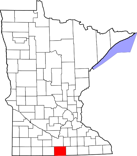
English: This is a locator map showing Faribault County in Minnesota. For more information, see Commons:United States county locator maps.
Date
Source Own work:
English: The maps use data from nationalatlas.gov, specifically countyp020.tar.gz on the Raw Data Download page. The maps also use state outline data from statesp020.tar.gz. The Florida maps use hydrogm020.tar.gz to display Lake Okeechobee.
Author David Benbennick

Licensing

Public domain I, the copyright holder of this work, release this work into the public domain. This applies worldwide.
In some countries this may not be legally possible; if so:
I grant anyone the right to use this work for any purpose, without any conditions, unless such conditions are required by law.

Captions

Add a one-line explanation of what this file represents

Items portrayed in this file

depicts

some value

12 February 2006

File history


Click on a date/time to view the file as it appeared at that time.
Date/TimeThumbnailDimensionsUserComment
current02:15, 25 June 2024Thumbnail for version as of 02:15, 25 June 20241,045 × 1,189 (67 KB)Nuxfix rendering (remove clipping)
13:13, 12 February 2006Thumbnail for version as of 13:13, 12 February 20065,746 × 6,539 (104 KB)David Benbennick{{subst:User:Dbenbenn/clm|county=Faribault County|state=Minnesota|type=county}}
13:02, 12 February 2006Thumbnail for version as of 13:02, 12 February 20065,746 × 6,539 (104 KB)David Benbennick{{subst:User:Dbenbenn/clm|county=Faribault County|state=Minnesota|type=county}}


The following pages on the English Wikipedia use this file (pages on other projects are not listed):

Barber Township, Faribault County, Minnesota

Baroda, Minnesota

Blue Earth, Minnesota

Blue Earth City Township, Faribault County, Minnesota

Bricelyn, Minnesota

Brush Creek, Minnesota

Brush Creek Township, Faribault County, Minnesota

Clark Township, Faribault County, Minnesota

Clayton, Minnesota

Delavan, Minnesota

Delavan Township, Faribault County, Minnesota

Dell, Minnesota

Dunbar Township, Faribault County, Minnesota

Easton, Minnesota

Elmore, Minnesota

Elmore Township, Faribault County, Minnesota

Emerald Township, Faribault County, Minnesota

Faribault County, Minnesota

Foster Township, Faribault County, Minnesota

Frost, Minnesota

Guckeen, Minnesota

Homedahl, Minnesota

Huntley, Minnesota

Jo Daviess Township, Faribault County, Minnesota

Kiester, Minnesota

Kiester Township, Faribault County, Minnesota

List of counties in Minnesota

Lura Township, Faribault County, Minnesota

Marna, Minnesota

Minnesota Lake, Minnesota

Minnesota Lake Township, Faribault County, Minnesota

National Register of Historic Places listings in Faribault County, Minnesota

Pilot Grove, Minnesota

Pilot Grove Township, Faribault County, Minnesota

Prescott Township, Faribault County, Minnesota

Rome Township, Faribault County, Minnesota

Seely Township, Faribault County, Minnesota

Verona Township, Faribault County, Minnesota

Walnut Lake Township, Faribault County, Minnesota

Walters, Minnesota

Wells, Minnesota

Winnebago, Minnesota

Winnebago City Township, Faribault County, Minnesota

User:Nyttend/County templates/MN/1

Template:Faribault County, Minnesota

Category:Populated places in Faribault County, Minnesota


Global file usage


The following other wikis use this file:

Usage on ar.wikipedia.org

مقاطعة فاريبولت (مينيسوتا)

بلو إيرث

بركلين

ديلافان (مينيسوتا)

إيستون (مينيسوتا)

إلمور (مينيسوتا)

فورست (مينيسوتا)

كيستير

مينيسوتا ليك

والترز (مينيسوتا)

ويلز (مينيسوتا)

وينيباغو

قالب:مقاطعة فاريبولت (مينيسوتا)


Usage on bar.wikipedia.org

Faribault County, Minnesota


Usage on bg.wikipedia.org

Ферибоу (окръг, Минесота)


Usage on bpy.wikipedia.org

ি ি, ি


Usage on ca.wikipedia.org

Blue Earth

Bricelyn

Delavan (Minnesota)

Easton (Minnesota)

Elmore (Minnesota)

Frost (Minnesota)

Kiester

Minnesota Lake

Walters (Minnesota)

Wells (Minnesota)

Winnebago (Minnesota)

Plantilla:Comtat de Faribault


Usage on cdo.wikipedia.org

Faribault Gông (Minnesota)


Usage on ceb.wikipedia.org

Faribault County


Usage on ce.wikipedia.org

Фэрибо (гуо, Миннесота)


Usage on cy.wikipedia.org

Faribault County, Minnesota


Usage on da.wikipedia.org

Bruger:Orwell123/Minnesota County7.

Faribault County

Liste over counties i Minnesota


Usage on de.wikipedia.org

Liste der Countys in Minnesota

Blue Earth

Faribault County

Winnebago (Minnesota)

Kiester

Minnesota Lake

Vernon Center

Liste der Einträge im National Register of Historic Places im Faribault County

Vorlage:Navigationsleiste Orte im Faribault County


Usage on es.wikipedia.org

Condado de Faribault

Categoría:Condado de Faribault


Usage on et.wikipedia.org

Faribaulti maakond

Minnesota maakondade loend


Usage on eu.wikipedia.org

Faribault konderria (Minnesota)


Usage on fa.wikipedia.org

بلو ارث، مینهسوتا


View more global usage of this file.

Metadata

This file contains additional information, probably added from the digital camera or scanner used to create or digitize it.

If the file has been modified from its original state, some details may not fully reflect the modified file.


Retrieved from "https://en.wikipedia.org/wiki/File:Map_of_Minnesota_highlighting_Faribault_County.svg"


Languages


This page is not available in other languages.
 

Wikipedia


Privacy policy

About Wikipedia

Disclaimers

Contact Wikipedia

Code of Conduct

Developers

Statistics

Cookie statement

Terms of Use

Desktop