Original file (SVG file, nominally 976 × 907 pixels, file size: 845 KB)
| This is a file from the Wikimedia Commons. Information from its description page there is shown below. Commons is a freely licensed media file repository. You can help. |
| DescriptionMap of Sunda and Sahul.svg |
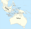
Català: Mapa de SondaiSahul (marcat per un contorn de 125 m de profunditat) i la Línia de Wallace, la Línia de Weber i la Línia de Lydekker.
English: Map of Sunda and Sahul (marked by 125m depth contour) and the Wallace Line, the Weber Line and the Lydekker Line.
|
|||||||||
| Key InfoField | ||||||||||
| Date | ||||||||||
| Source |
Own work, based on file:map of Sunda and Sahul.png and using
|
|||||||||
| Creator | ||||||||||
| Geotemporal data | ||||||||||
| Spatial reference system | equirectangular | |||||||||
| Bounding box |
|
|||||||||
| Other versions |
File:Map of Sunda and Sahul.svg has 2 translations.
Other related versions: Map of Sunda and Sahul.png:  |
|||||||||
| This SVG file contains embedded text that can be translated into your language, using any capable SVG editor, text editor or the SVG Translate tool. For more information see: About translating SVG files. |
This file is translated using SVG <switch> elements. All translations are stored in the same file! Learn more.
For most Wikipedia projects, you can embed the file normally (without a To translate the text into your language, you can use the SVG Translate tool. Alternatively, you can download the file to your computer, add your translations using whatever software you're familiar with, and re-upload it with the same name. You will find help in Graphics Lab if you're not sure how to do this. |

|
Permission is granted to copy, distribute and/or modify this document under the terms of the GNU Free Documentation License, Version 1.2 or any later version published by the Free Software Foundation; with no Invariant Sections, no Front-Cover Texts, and no Back-Cover Texts. A copy of the license is included in the section entitled GNU Free Documentation License.http://www.gnu.org/copyleft/fdl.htmlGFDLGNU Free Documentation Licensetruetrue |
| Date/Time | Thumbnail | Dimensions | User | Comment | |
|---|---|---|---|---|---|
| current | 23:42, 12 April 2024 |  | 976 × 907 (845 KB) | Manlleus | File uploaded using svgtranslate tool (https://svgtranslate.toolforge.org/). Added translation for ca. |
| 23:34, 12 April 2024 |  | 976 × 907 (845 KB) | Manlleus | File uploaded using svgtranslate tool (https://svgtranslate.toolforge.org/). Added translation for ca. | |
| 15:07, 16 January 2023 |  | 976 × 907 (841 KB) | Kanguole | {{Map |Description={{en|Map of Sunda and Sahul (marked by 125m depth contour) and the Wallace Line, the Weber Line and the Lydekker Line.}} |Projection=equirectangular |Latitude=-45/20.2 |Longitude=91/162.8 |Warp status=skip |Source={{own}}, using * Coastline from [http://www.naturalearthdata.com/downloads/50m-physical-vectors/ Natural Earth 1:50m Physical Vectors] * 125m depth contour derived... |
This file contains additional information, probably added from the digital camera or scanner used to create or digitize it.
If the file has been modified from its original state, some details may not fully reflect the modified file.
| Width | 975.7858797471922 |
|---|---|
| Height | 907.2538499651797 |