Home  

Random  

Nearby  


Log in  


Settings  


Donate  


About Wikipedia  

Disclaimers  


Wikipedia


File:Mexico Sonora location map.svg


File  

Talk  


Language  

Watch  


File

File history

File usage

Global file usage

Metadata
File:Mexico Sonora location map.svg
Size of this PNG preview of this SVG file: 512 × 500 pixels. Other resolutions: 246 × 240 pixels | 492 × 480 pixels | 786 × 768 pixels | 1,049 × 1,024 pixels | 2,097 × 2,048 pixels.

Original file(SVG file, nominally 512 × 500 pixels, file size: 976 KB)


Summary

Description
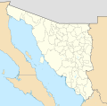
English: Location map of Sonora with the urban areas.

EPSG:3857 projection, Geographic limits of the map:

  • N: 32.80° N
  • S: 26.00° N
  • W: 115.50° W
  • E: 107.50° W
Date
Source
Author

Addicted04

Licensing

w:en:Creative Commons
attribution share alike
This file is licensed under the Creative Commons Attribution-Share Alike 4.0 International license.
You are free:
  • to share – to copy, distribute and transmit the work
  • to remix – to adapt the work
  • Under the following conditions:

    Captions

    Add a one-line explanation of what this file represents

    Items portrayed in this file

    depicts

    26 May 2015

    File history


    Click on a date/time to view the file as it appeared at that time.
    Date/TimeThumbnailDimensionsUserComment
    current07:36, 26 May 2015Thumbnail for version as of 07:36, 26 May 2015512 × 500 (976 KB)MilenioscuroUser created page with UploadWizard


    The following pages on the English Wikipedia use this file (pages on other projects are not listed):

    Agiabampo

    Agiabampo Estuary

    Agua Prieta

    Altar, Sonora

    Arizpe

    Banámichi

    Buenavista mine

    Caborca

    Ciudad Obregón

    Ciudad Obregón International Airport

    Colonia Soto, Sonora

    El Chanate

    El Salado

    Fronteras

    Guaymas

    Guaymas International Airport

    Hermosillo

    Hermosillo International Airport

    Hermosillo Municipality

    Huatabampo

    Isla Ángel de la Guarda

    La Caridad Mine

    La Colorada Municipality

    Las Bocas, Sonora

    Las Delicias, Sonora

    Mar de Cortés International Airport

    Mulatos gold mine

    Navojoa

    Navojoa Airport

    Nogales International Airport (Mexico)

    Northern Jaguar Reserve

    Opodepe

    Opodepe Municipality

    Pinacate Peaks

    Puerto Libertad, Sonora

    San Luis Río Colorado

    San Luis Río Colorado Airport

    Santa Cruz, Sonora

    Santa Cruz Municipality, Sonora

    Sierra El Aliso

    Sáric

    Tiburón Island

    Ures

    Álamos

    Ímuris

    User:Sumiaz/Opata

    User:Sumiaz/sandbox

    User:Ty654/List of earthquakes from 1910-1919 exceeding magnitude 6+

    User:Ty654/List of earthquakes from 1930-1939 exceeding magnitude 6+

    User:Ty654/List of earthquakes from 1940-1949 exceeding magnitude 6+

    User:Ty654/List of earthquakes from 1950-1954 exceeding magnitude 6+

    User:Ty654/List of earthquakes from 1965-1969 exceeding magnitude 6+

    User:Ty654/List of earthquakes from 1980-1984 exceeding magnitude 6+

    User:Ty654/List of earthquakes from 2005-2009 exceeding magnitude 6+

    Module:Location map/data/Mexico Sonora

    Module:Location map/data/Mexico Sonora/doc


    Global file usage


    The following other wikis use this file:

    Usage on azb.wikipedia.org

    آلتار، سونورا

    سان لوئیس ریو کولورادو


    Usage on bar.wikipedia.org

    Guaymas

    Arizpe

    Vorlog:Positionskarte Mexiko Sonora


    Usage on ce.wikipedia.org

    Кеп:Меттиган карта Мексика Сонора


    Usage on de.wikipedia.org

    Hermosillo

    Ciudad Obregón

    Magdalena de Kino

    Atil (Sonora)

    Altar (Sonora)

    Nogales (Sonora)

    Navojoa

    Guaymas

    San Luis Río Colorado

    Oquitoa

    Trincheras

    Álvaro-Obregón-Talsperre (Sonora)

    La Arizona

    El Derrumbadero (Sonora)

    Las Borregas

    Las Plomosas

    San Francisquito

    Sonoita (Sonora)

    Banori

    Agua Prieta

    Benjamín Hill (Ort)

    Arizpe

    Cananea

    Empalme

    Huatabampo

    Álamos

    Etchojoa

    Caborca

    Santa Ana (Sonora)

    Naco (Sonora)

    Bahía de Kino

    La Cebolla

    La Reforma (Tubutama)

    La Colorada (Mexiko)

    Unámichi

    Sásabe (Sonora)

    Guisamopa

    Sahuaripa

    Fronteras

    Cerro del Pinacate

    Los Janos

    Puerto Peñasco

    Moctezuma (Sonora)

    Wikipedia:Kartenwerkstatt/Positionskarten/Nordamerika


    View more global usage of this file.

    Metadata

    This file contains additional information, probably added from the digital camera or scanner used to create or digitize it.

    If the file has been modified from its original state, some details may not fully reflect the modified file.


    Retrieved from "https://en.wikipedia.org/wiki/File:Mexico_Sonora_location_map.svg"


    Languages


    This page is not available in other languages.
     

    Wikipedia


    Privacy policy

    About Wikipedia

    Disclaimers

    Contact Wikipedia

    Code of Conduct

    Developers

    Statistics

    Cookie statement

    Terms of Use

    Desktop