Home  

Random  

Nearby  


Log in  


Settings  


Donate  


About Wikipedia  

Disclaimers  


Wikipedia


File:Midlothian UK location map.svg


File  

Talk  


Language  

Watch  


File

File history

File usage

Global file usage
File:Midlothian UK location map.svg
Size of this PNG preview of this SVG file: 651 × 600 pixels. Other resolutions: 261 × 240 pixels | 521 × 480 pixels | 834 × 768 pixels | 1,111 × 1,024 pixels | 2,223 × 2,048 pixels | 1,425 × 1,313 pixels.

Original file(SVG file, nominally 1,425 × 1,313 pixels, file size: 796 KB)


Description

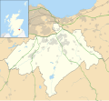
Blank map of Midlothian, UK with the following information shown:

  • Administrative borders
  • Coastline, lakes and rivers
  • Roads and railways
  • Urban areas

Equirectangular map projection on WGS 84 datum, with N/S stretched 175%

Geographic limits:

  • West: 3.39W
  • East: 2.82W
  • North: 56.00N
  • South: 55.70N
Date
Source

Ordnance Survey OpenData.

Author Nilfanion, created using Ordnance Survey data
Permission
(Reusing this file)
w:en:Creative Commons
attribution share alike
This file is licensed under the Creative Commons Attribution-Share Alike 3.0 Unported license.
Attribution: Contains Ordnance Survey data © Crown copyright and database right
You are free:
  • to share – to copy, distribute and transmit the work
  • to remix – to adapt the work
  • Under the following conditions:
    • attribution – You must give appropriate credit, provide a link to the license, and indicate if changes were made. You may do so in any reasonable manner, but not in any way that suggests the licensor endorses you or your use.
    • share alike – If you remix, transform, or build upon the material, you must distribute your contributions under the same or compatible license as the original.
    Other versions File:Midlothian UK blank map.svg - Blank map

    Captions

    Add a one-line explanation of what this file represents

    Items portrayed in this file

    depicts

    26 September 2010

    File history


    Click on a date/time to view the file as it appeared at that time.
    Date/TimeThumbnailDimensionsUserComment
    current20:17, 26 September 2010Thumbnail for version as of 20:17, 26 September 20101,425 × 1,313 (796 KB)Nilfanion{{Information |Description=Blank map of Midlothian, UK with the following information shown: *Administrative borders *Coastline, lakes and rivers *Roads and railways *Urban areas Equirectangular map projection on WGS 84 datum, with N/S s


    The following pages on the English Wikipedia use this file (pages on other projects are not listed):

    Arniston, Midlothian

    Auchendinny

    Bilston, Midlothian

    Birkenside, Midlothian

    Bonnyrigg

    Borthwick

    Brunstane Castle

    Carrington, Midlothian

    Cockpen

    Corn Exchange, Dalkeith

    Cranston, Midlothian

    Crichton, Midlothian

    Crichton Castle

    D'Arcy, Midlothian

    Dalkeith

    Danderhall

    Dewartown

    Easter Howgate

    Easthouses

    Edgehead

    Eskbank railway station

    Fala, Midlothian

    Glencorse

    Glencorse Barracks

    Gorebridge

    Gorebridge railway station

    Hillend, Edinburgh

    Hopefield, Bonnyrigg

    Lasswade

    List of monastic houses in Scotland

    Loanhead

    Mayfield, Midlothian

    Midlothian

    Midlothian Community Hospital

    Municipal Buildings, Dalkeith

    Newbattle

    Newtongrange

    Newtongrange railway station

    Nine Mile Burn

    North Middleton, Midlothian

    Oxenfoord Castle

    Pathhead, Midlothian

    Penicuik

    Penicuik Town Hall

    Polton

    Preston Hall, Midlothian

    Rosewell, Midlothian

    Roslin, Midlothian

    Rosslyn Chapel

    Rosslynlee Hospital

    Shawfair

    Shawfair railway station

    Silverburn, Midlothian

    St David's Church, Dalkeith

    Temple, Midlothian

    Whitehill, Midlothian

    Module:Location map/data/Scotland Midlothian

    Module:Location map/data/Scotland Midlothian/doc


    Global file usage


    The following other wikis use this file:

    Usage on ar.wikipedia.org

    قالب:Location map Scotland Midlothian


    Usage on bg.wikipedia.org

    Шаблон:ПК Великобритания Мидлоудиън


    Usage on ceb.wikipedia.org

    Plantilya:Location map Scotland Midlothian


    Usage on de.wikipedia.org

    Vorlage:Positionskarte Schottland Midlothian


    Usage on eo.wikipedia.org

    Midlothian


    Usage on es.wikipedia.org

    Embalse de Gladhouse

    Wikiproyecto:Ilustración/Taller de Cartografía/Realizaciones/Europa

    Plantilla:Mapa de localización de Midlothian

    Loanhead

    Pathhead

    Gorebridge

    Dalkeith

    Newbattle

    Bonnyrigg

    Bilston (Midlothian)

    Rosewell

    Penicuik

    Danderhall


    Usage on fa.wikipedia.org

    الگو:Location map Scotland Midlothian

    برانستین (دژ)

    روسلین، میدلودین

    بانیریگ

    دالکیت

    لونهد

    لسوید

    گوربریج

    نمازخانه راسلین


    Usage on fr.wikipedia.org

    Liste des commanderies templières dans le Lothian

    Penicuik

    Dalkeith

    Modèle:Géolocalisation/Midlothian

    Roslin

    Rosewell


    Usage on ja.wikipedia.org

    Template:Location map Scotland Midlothian


    :Location map/data/Scotland Midlothian

    :Location map/data/Scotland Midlothian/doc


    Usage on kn.wikipedia.org

    :Location map Scotland Midlothian


    Usage on nl.wikipedia.org

    Rosslyn Chapel

    Penicuik

    Lasswade

    Auchendinny

    Dalkeith

    Gorebridge

    Sjabloon:Positiekaart Midlothian

    Bonnyrigg


    Usage on pl.wikipedia.org

    Midlothian

    Dalkeith

    Kaplica Rosslyn


    View more global usage of this file.

    Retrieved from "https://en.wikipedia.org/wiki/File:Midlothian_UK_location_map.svg"


    Languages


    This page is not available in other languages.
     

    Wikipedia


    Privacy policy

    About Wikipedia

    Disclaimers

    Contact Wikipedia

    Code of Conduct

    Developers

    Statistics

    Cookie statement

    Terms of Use

    Desktop