Home  

Random  

Nearby  


Log in  


Settings  


Donate  


About Wikipedia  

Disclaimers  


Wikipedia


File:Netherlands location map.svg


File  

Talk  


Language  

Watch  


File

File history

File usage

Global file usage

Metadata
File:Netherlands location map.svg
Size of this PNG preview of this SVG file: 532 × 600 pixels. Other resolutions: 213 × 240 pixels | 426 × 480 pixels | 681 × 768 pixels | 908 × 1,024 pixels | 1,817 × 2,048 pixels | 888 × 1,001 pixels.

Original file(SVG file, nominally 888 × 1,001 pixels, file size: 139 KB)


Summary

Description
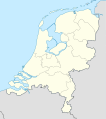
Deutsch: Positionskarte der Niederlande

Quadratische Plattkarte, N-S-Streckung 160 %. Geographische Begrenzung der Karte:

  • N: 53.7° N
  • S: 50.6° N
  • W: 3.1° O
  • O: 7.5° O
English: Location map of the Netherlands

Equirectangular projection, N/S stretching 160 %. Geographic limits of the map:

  • N: 53.7° N
  • S: 50.6° N
  • W: 3.1° E
  • O: 7.5° E
Date
Source

own work, using

  • United States National Imagery and Mapping Agency data
  • World Data Base II data
Author Lencer
Other versions Derivative works of this file:  Regenbogen location map.svg
Kartenwerkstatt
This map has been made or improved in the German Kartenwerkstatt (Map Lab). You can propose maps to improve as well.

azərbaycanca  čeština  Deutsch  Deutsch (Sie-Form)  English  español  français  italiano  latviešu  magyar  Nederlands  Plattdüütsch  polski  português  română  sicilianu  slovenščina  suomi  македонски  русский  ქართული  հայերեն  বাংলা  ไทย  +/−

Licensing

I, the copyright holder of this work, hereby publish it under the following licenses:
GNU head Permission is granted to copy, distribute and/or modify this document under the terms of the GNU Free Documentation License, Version 1.2 or any later version published by the Free Software Foundation; with no Invariant Sections, no Front-Cover Texts, and no Back-Cover Texts. A copy of the license is included in the section entitled GNU Free Documentation License.
w:en:Creative Commons
attribution share alike
This file is licensed under the Creative Commons Attribution-Share Alike 3.0 Unported license.
You are free:
  • to share – to copy, distribute and transmit the work
  • to remix – to adapt the work
  • Under the following conditions:
    You may select the license of your choice.

    Captions

    Location map of the Netherlands

    Items portrayed in this file

    depicts

    some value

    24 July 2008

    image/svg+xml

    File history


    Click on a date/time to view the file as it appeared at that time.
    (newest | oldest) View (newer 10 | ) (10 | 20| 50| 100 | 250 | 500)
    Date/TimeThumbnailDimensionsUserComment
    current11:26, 5 January 2019Thumbnail for version as of 11:26, 5 January 2019888 × 1,001 (139 KB)Thaytssmall border corrections
    12:26, 2 January 2019Thumbnail for version as of 12:26, 2 January 2019888 × 1,001 (139 KB)Thaytsfixed border segments
    11:54, 30 December 2018Thumbnail for version as of 11:54, 30 December 2018888 × 1,001 (145 KB)NordNordWestupd 2019
    22:25, 17 February 2013Thumbnail for version as of 22:25, 17 February 2013888 × 1,001 (153 KB)Io Herodotusadded Maasvakte2
    16:57, 31 July 2012Thumbnail for version as of 16:57, 31 July 2012888 × 1,001 (145 KB)NordNordWestupd
    16:56, 31 July 2012Thumbnail for version as of 16:56, 31 July 2012888 × 1,001 (145 KB)NordNordWestupd
    17:32, 3 March 2011Thumbnail for version as of 17:32, 3 March 2011888 × 1,001 (225 KB)Lencerfix border
    16:26, 11 September 2008Thumbnail for version as of 16:26, 11 September 2008888 × 1,001 (230 KB)Lencer{{Information |Description= |Source= |Date= |Author= |Permission= |other_versions= }}
    15:15, 10 September 2008Thumbnail for version as of 15:15, 10 September 2008888 × 1,001 (230 KB)Lencer{{Information |Description= |Source= |Date= |Author= |Permission= |other_versions= }}
    18:35, 9 September 2008Thumbnail for version as of 18:35, 9 September 2008888 × 1,001 (229 KB)Lencer{{Information |Description= |Source= |Date= |Author= |Permission= |other_versions= }}

    (newest | oldest) View (newer 10 | ) (10 | 20| 50| 100 | 250 | 500)


    More than 100 pages use this file. The following list shows the first 100 pages that use this file only. A full list is available.

    's-Gravendeel

    Aalburg

    Aalsmeer

    Aalten

    America, Netherlands

    Amerongen

    Amsterdam Airport Schiphol

    Andijk

    Angerlo

    Anna Paulowna

    Appingedam

    Bathmen

    Bedum

    Bennebroek

    Bergschenhoek

    Berkel en Rodenrijs

    Bleiswijk

    Bodegraven

    Bolsward

    Boskoop

    Boxmeer

    Didam

    Dinxperlo

    Dirksland

    Doorn

    Driebergen-Rijsenburg

    Eijsden

    Elburg

    Geldermalsen

    Gendringen

    Groenlo

    Groesbeek

    Haaren, North Brabant

    Haelen

    Haren, Groningen

    Helden, Limburg

    Heythuysen

    Hook of Holland

    Hulst

    Hunsel

    Leek, Netherlands

    Leersum

    Leiden University

    Leidschendam-Voorburg

    Lichtenvoorde

    List of football clubs in the Netherlands

    Lith, Netherlands

    Loppersum

    Maasbracht

    Maasbree

    Maasland

    Margraten

    Marum

    Meijel

    Middelharnis

    Mierlo

    Mook en Middelaar

    Muiden

    Naarden

    Neede

    Neerijnen

    Nuth

    Obdam

    Oostburg

    Otterlo

    Oud-Beijerland

    Ravenstein, Netherlands

    Rijnsburg

    Roerdalen

    Rotterdam

    Ruurlo

    Sas van Gent

    Scheveningen

    Schijndel

    Schinnen

    Sevenum

    Sint-Oedenrode

    Sneek

    Staphorst

    Steenderen

    Susteren

    Ten Boer

    Thorn, Netherlands

    Tilburg

    Twenterand

    Ubbergen

    Uden

    Urk

    Veghel

    Venhuizen

    Vlagtwedde

    Vorden

    Vught

    Warnsveld

    Weert

    Wehl

    Werkendam

    Wervershoof

    Wijk bij Duurstede

    Winschoten


    View more links to this file.

    Global file usage


    The following other wikis use this file:

    Usage on af.wikipedia.org

    Lughawe Schiphol

    Amersfoort

    Kruiningen

    Sjabloon:Liggingkaart Nederland

    Waarde (plek)

    Middelstum

    Stedum

    Garnwerd

    Adorp

    Ulrum

    Leens

    Kloosterburen

    Termunten

    Noordpolderzijl

    't Zandt

    Groede

    Krieketwêreldbeker 1999

    Saasveld, Nederland

    Nederlandse nasionale krieketspan


    Usage on als.wikipedia.org

    Fußball-Europameisterschaft 2000

    Vorlage:Positionskarte Niederlande


    Usage on am.wikipedia.org


    :Location map 


    Usage on an.wikipedia.org

    Rotterdam

    Amsterdam

    Aalsmeer

    Alkmaar

    Amstelveen

    Andijk

    Anna Paulowna

    Beemster

    Bergen (Holanda Septentrional)

    Beverwijk

    Blaricum

    Bloemendaal

    Bussum

    Castricum

    Den Helder

    Diemen

    Drechterland

    Edam-Volendam

    Enkhuizen

    Graft-De Rijp

    Haarlem

    Haarlemmerliede en Spaarnwoude


    View more global usage of this file.

    Metadata

    This file contains additional information, probably added from the digital camera or scanner used to create or digitize it.

    If the file has been modified from its original state, some details may not fully reflect the modified file.


    Retrieved from "https://en.wikipedia.org/wiki/File:Netherlands_location_map.svg"


    Languages


    This page is not available in other languages.
     

    Wikipedia


    Privacy policy

    About Wikipedia

    Disclaimers

    Contact Wikipedia

    Code of Conduct

    Developers

    Statistics

    Cookie statement

    Terms of Use

    Desktop