Home  

Random  

Nearby  


Log in  


Settings  


Donate  


About Wikipedia  

Disclaimers  


Wikipedia


File:Outline Map of Stavropol Krai.svg


File  

Talk  


Language  

Watch  


File

File history

File usage

Global file usage

Metadata
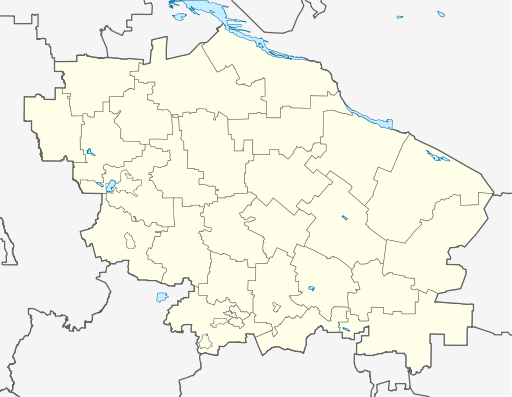
File:Outline Map of Stavropol Krai.svg
Size of this PNG preview of this SVG file: 512 × 397 pixels. Other resolutions: 310 × 240 pixels | 619 × 480 pixels | 991 × 768 pixels | 1,280 × 993 pixels | 2,560 × 1,985 pixels.

Original file(SVG file, nominally 512 × 397 pixels, file size: 190 KB)


Summary

Description
Русский: Позиционная карта Ставропольского края
  • Проекция — равноугольная.
  • Стандартная параллель — 45°00′00″с.ш.
  • Параметры шаблона (координаты краёв):
  • |top    = 46.4
    |bottom = 43.5
    |left   = 40.6
    |right  = 45.9
    
    Date
    Source

    Own work

     
    This W3C-unspecified vector image was created with Inkscape .
    Author Виктор В
    Other versions

    [edit]

    Licensing

    w:en:Creative Commons
    attribution share alike
    This file is licensed under the Creative Commons Attribution-Share Alike 2.0 Generic license.
    You are free:
    • to share – to copy, distribute and transmit the work
  • to remix – to adapt the work
  • Under the following conditions:

    Captions

    Add a one-line explanation of what this file represents

    Items portrayed in this file

    depicts

    2 September 2010

    File history


    Click on a date/time to view the file as it appeared at that time.
    Date/TimeThumbnailDimensionsUserComment
    current04:18, 7 September 2010Thumbnail for version as of 04:18, 7 September 2010512 × 397 (190 KB)Виктор Вошибся...
    04:17, 7 September 2010Thumbnail for version as of 04:17, 7 September 2010512 × 397 (190 KB)Виктор Висправления
    15:39, 2 September 2010Thumbnail for version as of 15:39, 2 September 2010512 × 397 (187 KB)Виктор В== {{int:filedesc}} == {{Information |Description={{ru|1=Позиционная карта Ставропольского края *Проекция — равноугольная. *Стандартная параллель — 45°00′00″с.ш. *Па�


    The following pages on the English Wikipedia use this file (pages on other projects are not listed):

    2014 Winter Olympics torch relay

    Abdul-Gazy

    Abram-Tyube

    Alexandrovskoye, Stavropol Krai

    Andzhiyevsky

    Arzgir

    Bezopasnoye

    Blagodarny, Stavropol Krai

    Budyonnovsk

    Budyonnovsk (air base)

    Donskoye, Stavropol Krai

    Georgiyevsk

    Goryachevodsky

    Grigoropolisskaya

    Inozemtsevo

    Ipatovo, Stavropol Krai

    Izobilny, Stavropol Krai

    Kislovodsk

    Kochubeyevskoye

    Krasnogvardeyskoye, Stavropol Krai

    Kursavka

    Lermontov (town)

    Lysogorskaya

    Mikhaylovsk, Stavropol Krai

    Mineralnye Vody

    Mineralnye Vody Airport

    Neftekumsk

    Nezlobnaya

    North Caucasian Federal District

    Novoalexandrovsk

    Novopavlovsk

    Orbelyanovka

    Prikumskoe

    Privolnoye, Stavropol Krai

    Pyatigorsk

    Ryzdvyany

    Solnechnodolsk

    Soluno-Dmitriyevskoye

    Stavropol

    Stavropol Shpakovskoye Airport

    Svetlograd

    Svobody

    Trunovskoye, Stavropol Krai

    Yessentuki

    Zaterechny (urban-type settlement)

    Zelenokumsk

    Zheleznovodsk

    Module:Location map/data/Russia Stavropol Krai

    Module:Location map/data/Russia Stavropol Krai/doc


    Global file usage


    The following other wikis use this file:

    Usage on af.wikipedia.org

    Stawropol

    Sjabloon:Liggingkaart Strawropol-krai


    Usage on ar.wikipedia.org

    قالب:Location map Russia Stavropol Krai


    Usage on azb.wikipedia.org

    آبدول-قازی

    آبرام-تیوب

    میخایلووسک، روسیه


    Usage on ba.wikipedia.org

    Ставрополь

    Ессентуки

    Ҡалып:ПозКарта Рәсәй Ставрополь крайы


    Usage on be.wikipedia.org

    Благадарны

    Будзёнаўск

    Георгіеўск

    Міхайлаўск (Стаўрапольскі край)

    Лермантаў (горад)

    Мінеральныя Воды

    Пяцігорск

    Светлаград

    Ізабільны

    Новапаўлаўск

    Есентукі

    Жалезнаводск

    Зеленакумск

    Нефцякумск

    Новааляксандраўск

    Іпатава (горад)

    Кіславодск

    Стаўрапаль

    Шаблон:На карце/Расія Стаўрапольскі край


    Usage on bg.wikipedia.org

    Шаблон:ПК Русия Ставрополски край


    Usage on bs.wikipedia.org

    Pjatigorsk


    Usage on ceb.wikipedia.org

    Plantilya:Location map Russia Stavropol Krai


    Usage on ce.wikipedia.org

    Ставрополь

    Будённовск

    Георгиевск

    Благодарни

    Изобильни (Изобильнин кӀошт)

    Ипатово (Ставрополан мохк)

    Новопавловск

    Михайловск (Ставрополан мохк)

    Зеленокумск

    Минвод

    Нефтекумск

    Новоалександровск

    Светлоград

    Пятигорск

    Ессентуки

    Кисловодск

    Железноводск

    Садови (Александровскан кӀошт)

    Харьковски (Александровскан кӀошт)


    View more global usage of this file.

    Metadata

    This file contains additional information, probably added from the digital camera or scanner used to create or digitize it.

    If the file has been modified from its original state, some details may not fully reflect the modified file.


    Retrieved from "https://en.wikipedia.org/wiki/File:Outline_Map_of_Stavropol_Krai.svg"


    Languages


    This page is not available in other languages.
     

    Wikipedia


    Privacy policy

    About Wikipedia

    Disclaimers

    Contact Wikipedia

    Code of Conduct

    Developers

    Statistics

    Cookie statement

    Terms of Use

    Desktop