Home  

Random  

Nearby  


Log in  


Settings  


Donate  


About Wikipedia  

Disclaimers  


Wikipedia


File:South Asia (orthographic projection) without national boundaries.svg


File  

Talk  


Language  

Watch  


File

File history

File usage

Global file usage

Metadata
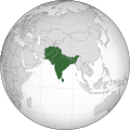
File:South Asia (orthographic projection) without national boundaries.svg
Size of this PNG preview of this SVG file: 550 × 550 pixels. Other resolutions: 240 × 240 pixels | 480 × 480 pixels | 768 × 768 pixels | 1,024 × 1,024 pixels | 2,048 × 2,048 pixels.

Original file(SVG file, nominally 550 × 550 pixels, file size: 2.8 MB)


Summary

Description
English: South Asia
Date (UTC)
Source
Author user:Serg!o
Other versions

This is a Grey & green orthographic projection map.

العربية: الرجاء، قراءة الميثاق.
বাংলা: দয়া করে, রীতিনীতিটি পড়ুন
Deutsch: Bitte lies die Konventionen.
English: Please, read the conventions.
Español: Por favor, lea las convenciones.
Filipino: Paki-basa ang mga kumbensyon.
Français : S'il vous plaît, lisez les conventions.
हिन्दी: कृपया सभागमों को पढ़ लें.
Bahasa Indonesia: Silakan, baca konvensi.
Italiano: Si prega di leggere le convenzioni.
日本語: 規約をご確認ください。
ქართული: გთხოვთ, გაეცნოთ კონვენციებს.
Português: Por favor, leia as convenções.
Русский: Пожалуйста, прочитайте соглашения.
Tagalog: Paki-basa ang mga kumbensyon.
Українська: Будь ласка, прочитайте конвенції.
Tiếng Việt: Hãy đọc công văn trước khi đăng.
中文(繁體):請檢視常規
中文(简体):请查看常规

World maps

Africa

हिन्दी: अफ्रीका
ქართული: აფრიკა.

Eastern Africa

Southern Africa

Central Africa

Northern Africa

Western Africa

Americas

ქართული: ამერიკა.
हिन्दी: अमेरिका

North America

Central America

Caribbean

South America

Asia

ქართული: აზია.
Português: Ásia.
Українська: Азія.

East

Português: Ásia Oriental.
Українська: Східна Азія.

Central

हिन्दी: मध्य एशिया
Português: Ásia Central.
Українська: Центральна Азія.

Southeast

Bahasa Indonesia: Asia tenggara
Português: Sudeste Asiático.

South

(भारतीय उपमहाद्वीप)
ქართული: სამხრეთი აზია.
Português: Sul da Ásia.
Українська: Південна Азія.

Western

ქართული: დასავლეთ აზია.
Português: Sudoeste da Ásia.
Українська: Передня Азія.

Europe

हिन्दी: यूरोप
ქართული: ევროპა.
Português: Europa.
Română: Europa.
Русский: Европа.
Українська: Європа.

Countries

Oceania

हिन्दी: ओशिआनिया
ქართული: ოკეანეთი.
Português: Oceania.
Українська: Океанія.

Intercontinental

Português: Intercontinental.
Українська: Міжконтинентальні.

Historical

English: Unions, Organizations, Kingdoms, Empires
Español: Uniones, Organizaciones, Reinos, Imperios
Filipino: Mga Unyon, Organisasyon, Kaharian, Imperyo
Français : Unions, Organisations, Royaumes, Empires
हिन्दी: संघ, संगठन, राज्य, साम्राज्य व ऐतिहासिक देश
ქართული: გაერთიანებები, ორგანიზაციები, სამეფოები, იმპერიები
Português: Estados extintos.
Tagalog: Mga Unyon, Organisasyon, Kaharian, Imperyo
Українська: Союзи, Організації, Королівства, Імперії
中文(繁體):聯盟、組織、王國和帝國
中文(简体):联盟、组织、王国和帝国

Subnationals

हिन्दी: उपराष्ट्रीय इकाईयाँ
SVG development

InfoField

 
The SVG code is valid.
 
This world map was created with Inkscape, or with something else.
This world map is a retouched picture, which means that it has been digitally altered from its original version. The original can be viewed here: India (orthographic projection).svg. Modifications made by Serg!o.

Licensing

I, the copyright holder of this work, hereby publish it under the following licenses:
w:en:Creative Commons
attribution share alike
This file is licensed under the Creative Commons Attribution-Share Alike 3.0 Unported license.
You are free:
  • to share – to copy, distribute and transmit the work
  • to remix – to adapt the work
  • Under the following conditions:
    GNU head Permission is granted to copy, distribute and/or modify this document under the terms of the GNU Free Documentation License, Version 1.2 or any later version published by the Free Software Foundation; with no Invariant Sections, no Front-Cover Texts, and no Back-Cover Texts. A copy of the license is included in the section entitled GNU Free Documentation License.
    GNU head Permission is granted to copy, distribute and/or modify this document under the terms of the GNU Free Documentation License, Version 1.2 or any later version published by the Free Software Foundation; with no Invariant Sections, no Front-Cover Texts, and no Back-Cover Texts. A copy of the license is included in the section entitled GNU Free Documentation License.
    You may select the license of your choice.

    The map has been created with the Generic Mapping Tools: https://www.generic-mapping-tools.org/ using one or more of these public-domain datasets for the relief:


    বাংলা  English  español  français  italiano  日本語  македонски  sicilianu  中文(简体)  中文(繁體)  +/−

    GNU head Permission is granted to copy, distribute and/or modify this document under the terms of the GNU Free Documentation License, Version 1.2 or any later version published by the Free Software Foundation; with no Invariant Sections, no Front-Cover Texts, and no Back-Cover Texts. A copy of the license is included in the section entitled GNU Free Documentation License.

    Captions

    South Asia (orthographic projection) without national boundaries

    Items portrayed in this file

    depicts

    image/svg+xml

    File history


    Click on a date/time to view the file as it appeared at that time.
    (newest | oldest) View (newer 10 | ) (10 | 20| 50| 100 | 250 | 500)
    Date/TimeThumbnailDimensionsUserComment
    current06:10, 12 November 2022Thumbnail for version as of 06:10, 12 November 2022550 × 550 (2.8 MB)Sourav BapuliAdded Siachen Glacier as requested by {{u|King Prithviraj II}}
    17:56, 1 January 2021Thumbnail for version as of 17:56, 1 January 2021553 × 553 (216 KB)Sbb1413Converted to Plain SVG.
    17:52, 1 January 2021Thumbnail for version as of 17:52, 1 January 2021553 × 553 (216 KB)Sbb1413The previous attempt failed, another attempt of correcting the errors.
    17:48, 1 January 2021Thumbnail for version as of 17:48, 1 January 2021553 × 553 (179 KB)Sbb1413Corrected W3C error.
    16:23, 24 August 2020Thumbnail for version as of 16:23, 24 August 2020553 × 553 (284 KB)ProsfilaesReverted to version as of 01:09, 24 August 2020 (UTC); consistency with historical use of this file. Upload distinct new versions to a new name
    12:12, 24 August 2020Thumbnail for version as of 12:12, 24 August 2020744 × 1,052 (540 KB)Xerxes1985Reverted to version as of 19:21, 22 August 2020 (UTC) It isn’t meant to be the important feature, it’s portrayed in a lighter colour due to its position as a link between south and Central Asia, or do you think Afghanistan has the same position in South Asia as Bangladesh, Pakistan or India ?
    01:09, 24 August 2020Thumbnail for version as of 01:09, 24 August 2020553 × 553 (284 KB)Aditya KabirReverted to version as of 20:10, 21 August 2020 (UTC) The South Asian map doesn't need Afghanistan as the most important feature
    19:21, 22 August 2020Thumbnail for version as of 19:21, 22 August 2020744 × 1,052 (540 KB)Xerxes1985Reverted to version as of 20:10, 19 August 2020 (UTC) Thats why it’s still in the map and not completely removed
    20:10, 21 August 2020Thumbnail for version as of 20:10, 21 August 2020553 × 553 (284 KB)PersianVReverted to version as of 18:07, 11 May 2017 (UTC) Reverted, technically considered South Asian
    20:10, 19 August 2020Thumbnail for version as of 20:10, 19 August 2020744 × 1,052 (540 KB)Xerxes1985Afghanistan in a lighter colour

    (newest | oldest) View (newer 10 | ) (10 | 20| 50| 100 | 250 | 500)


    More than 100 pages use this file. The following list shows the first 100 pages that use this file only. A full list is available.

    Asian cuisine

    Bangladesh

    Cemetery H culture

    Colonial India

    Company rule in India

    History of Bhutan

    History of India

    History of Nepal

    History of Pakistan

    History of Punjab

    History of South India

    India

    Indian religions

    Indo-Pakistani wars and conflicts

    Indo-Parthian Kingdom

    Indo-Scythians

    Indus Valley Civilisation

    Khalistan movement

    Maldives

    Mehrgarh

    Middle kingdoms of India

    Nanda Empire

    Nepal

    Outline of South Asian history

    Pakistan

    Portuguese India

    South Asian Association for Regional Cooperation

    Sri Lanka

    Talk:Abdul Qadeer Khan

    Talk:Afghan Army

    Talk:Afghan Civil War (19281929)

    Talk:Afonso de Albuquerque

    Talk:Armed Forces Medical College

    Talk:Arthur Wellesley, 1st Duke of Wellington

    Talk:Bajirao I

    Talk:Bangalore torpedo

    Talk:Bathurst-class corvette

    Talk:Battle of Aong

    Talk:Battle of Mogadishu (1993)

    Talk:Battle of the Hydaspes

    Talk:Bonn Agreement (Afghanistan)

    Talk:British Indian Army

    Talk:Causes of World War II

    Talk:Chanakya

    Talk:Chandragupta Maurya

    Talk:China Burma India theater

    Talk:Commander-in-chief

    Talk:Comparative officer ranks of World War II

    Talk:Constable

    Talk:Dassault Mirage III

    Talk:Democratic Republic of Afghanistan

    Talk:Durand Line

    Talk:First lieutenant

    Talk:George Washington

    Talk:Great Game

    Talk:HMS Hermes (R12)

    Talk:Hamid Karzai

    Talk:Hugh Henry Gough

    Talk:Hyder Ali

    Talk:Indira Gandhi

    Talk:Italian campaign (World War II)

    Talk:Kashmir

    Talk:Khalistan movement

    Talk:Korean War

    Talk:Kshatriya

    Talk:LeeEnfield

    Talk:List of timelines of World War II

    Talk:Maratha Confederacy

    Talk:Muhammad Zia-ul-Haq

    Talk:North African campaign

    Talk:Occupied territory

    Talk:Operation Blue Star

    Talk:Operation Infinite Reach

    Talk:Pacific War

    Talk:Pakistan Air Force

    Talk:Pakistan Armed Forces

    Talk:Pervez Musharraf

    Talk:Privateer

    Talk:Rajput

    Talk:Rashid Minhas

    Talk:Reginald Dyer

    Talk:Research and Analysis Wing

    Talk:Sam Browne

    Talk:Second Battle of El Alamein

    Talk:Shivaji

    Talk:Sino-Indian War

    Talk:Smiling Buddha

    Talk:SovietAfghan War

    Talk:Special forces of India

    Talk:Squadron leader

    Talk:Sri Lankan Civil War

    Talk:Subhas Chandra Bose

    Talk:Submarine-launched cruise missile

    Talk:T-90

    Talk:Tipu Sultan

    Talk:Warrant officer

    Talk:World War I

    Talk:World War II

    Talk:World War II casualties

    Template:History of South Asia


    View more links to this file.

    Global file usage


    The following other wikis use this file:

    Usage on af.wikipedia.org

    Suid-Asië


    Usage on am.wikipedia.org


    Usage on ar.wikipedia.org

    جنوب آسيا

    قائمة مفاتيح الاتصال الدولية


    Usage on arz.wikipedia.org

    لستة كود التيليفون لبلاد العالم

    جنوب اسيا


    Usage on ast.wikipedia.org

    Asia del Sur

    Asociación Sudasiática pa la Cooperación Rexonal


    Usage on azb.wikipedia.org

    جنوبی آسیا


    Usage on az.wikipedia.org

    Cənubi Asiya


    Usage on ban.wikipedia.org

    India

    Mal:Asia Kelod


    Usage on bar.wikipedia.org

    Sidasien


    Usage on ba.wikipedia.org

    Көньяҡ Азия төбәк хеҙмәттәшлеге ассоциацияһы

    Көньяҡ Азия


    Usage on bcl.wikipedia.org

    Habagatan na Asya


    Usage on be-tarask.wikipedia.org

    Паўднёвая Азія


    Usage on be.wikipedia.org

    Паўднёвая Азія


    Usage on bg.wikipedia.org

    Южна Азия


    Usage on bh.wikipedia.org

    ि ि

    ि ि   


    Usage on bjn.wikipedia.org

    Bangladisa

    Bhutan

    Hindia

    Maladewa

    Nepal

    Pakistan

    Citakan:Asia Salatan


    Usage on bn.wikipedia.org


    ি


    ি


    ি  ি ি 

    ি ি


    :ি ি 

     ি

     ি

    :ি 

    :

    :Jayantanth/Sandbox

      ি িি

     ি 

    :

    :ি

    :

    :ি/


    View more global usage of this file.

    Metadata

    This file contains additional information, probably added from the digital camera or scanner used to create or digitize it.

    If the file has been modified from its original state, some details may not fully reflect the modified file.


    Retrieved from "https://en.wikipedia.org/wiki/File:South_Asia_(orthographic_projection)_without_national_boundaries.svg"


    Languages


    This page is not available in other languages.
     

    Wikipedia


    Privacy policy

    About Wikipedia

    Disclaimers

    Contact Wikipedia

    Code of Conduct

    Developers

    Statistics

    Cookie statement

    Terms of Use

    Desktop