Home  

Random  

Nearby  


Log in  


Settings  


Donate  


About Wikipedia  

Disclaimers  


Wikipedia


File:South Korea adm location map.svg


File  

Talk  


Language  

Watch  


File

File history

File usage

Global file usage

Metadata
File:South Korea adm location map.svg
Size of this PNG preview of this SVG file: 635 × 599 pixels. Other resolutions: 254 × 240 pixels | 509 × 480 pixels | 814 × 768 pixels | 1,085 × 1,024 pixels | 2,171 × 2,048 pixels | 1,772 × 1,672 pixels.

Original file(SVG file, nominally 1,772 × 1,672 pixels, file size: 375 KB)


Summary

Description
Deutsch: Positionskarte von Südkorea
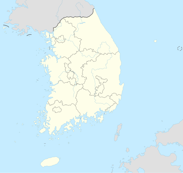
English: Location map of South Korea

Equirectangular projection, vertical stretching 120 %
Border coordinates

38.9
124.5←↕→132.0
33.0
 Info This map is part of a series of location maps with unified standards: SVG as file format, standardised colours and name scheme. The boundaries on these maps always show the de facto situation and do not imply any endorsement or acceptance. In case of changes of the shown area the file is updated. The old version will be uploaded as a new file and thus is still available.
Date
Source

Own work using:

  • United States National Imagery and Mapping Agency data
  • World Data Base II data
Author NordNordWest
Other versions
Kartenwerkstatt
This map has been made or improved in the German Kartenwerkstatt (Map Lab). You can propose maps to improve as well.

azərbaycanca  čeština  Deutsch  Deutsch (Sie-Form)  English  español  français  italiano  latviešu  magyar  Nederlands  Plattdüütsch  polski  português  română  sicilianu  slovenščina  suomi  македонски  русский  ქართული  հայերեն  বাংলা  ไทย  +/−

Licensing

Usage of this file with:

Map: NordNordWest, Licence: Creative Commons by-sa-3.0 de

explanatory notes: Legally binding is only the full legalcode. For a free usage I recommend to respect the following licence conditions:
1. Provide my name as given above: NordNordWest,
2. a copy of, or the URI for, the applicable license: https://creativecommons.org/licenses/by-sa/3.0/de/legalcode,
3. the title of the work,
4. in the case of an adaptation, a credit identifying the use of the work in the adaptation.
This license and the rights granted hereunder will terminate automatically upon any breach by you of the terms of this license. Any of the above conditions can be waived if you get permission from the copyright holder. If you have questions or wish differing conditions, please contact me through nnwest@t-online.deormy discussion page

w:en:Creative Commons
attribution share alike
This file is licensed under the Creative Commons Attribution-Share Alike 3.0 Germany license.
Attribution: Karte: NordNordWest, Lizenz: Creative Commons by-sa-3.0 de
You are free:
  • to share – to copy, distribute and transmit the work
  • to remix – to adapt the work
  • Under the following conditions:

    Captions

    Add a one-line explanation of what this file represents

    Items portrayed in this file

    depicts

    13 September 2015

    image/svg+xml

    File history


    Click on a date/time to view the file as it appeared at that time.
    Date/TimeThumbnailDimensionsUserComment
    current15:25, 5 July 2023Thumbnail for version as of 15:25, 5 July 20231,772 × 1,672 (375 KB)NordNordWestupd coastline
    04:49, 4 July 2023Thumbnail for version as of 04:49, 4 July 20231,772 × 1,672 (388 KB)Nv7801Daegu
    19:48, 22 June 2016Thumbnail for version as of 19:48, 22 June 20161,772 × 1,672 (382 KB)NordNordWestcorr
    17:51, 13 September 2015Thumbnail for version as of 17:51, 13 September 20151,772 × 1,672 (382 KB)NordNordWest== {{int:filedesc}} == {{Information |Description= {{de|1=Positionskarte von Südkorea}} {{en|1=Location map of South Korea}} {{Location map series N |stretching=120 |top=38.9 |bottom=33.0 |left=124.5 |right=132.0}} |Source={{Own using}} * United State...


    More than 100 pages use this file. The following list shows the first 100 pages that use this file only. A full list is available.

    1960 AFC Asian Cup

    2001 FIFA Confederations Cup

    2002 FIFA World Cup

    2003 Peace Cup

    2005 Peace Cup

    2007 FIFA U-17 World Cup

    Baekdamsa

    Baengnyeonsa

    Battle of Okpo

    Battle of the Imjin River

    Beomeosa

    Bukhansan National Park

    Camp Humphreys

    Changwon

    Cheongju International Airport

    Daebudo

    Daeseong-dong

    Dongguk University

    Donghwasa

    Dongmyo

    Dongseo University

    Eunhaesa

    Football at the 1988 Summer Olympics

    Gachang

    Gangjin-eup

    Gayasan National Park

    Geumgoksa

    Gimhae International Airport

    Gimpo International Airport

    Gochang, Hwasun and Ganghwa Dolmen Sites

    Golgulsa

    Guinsa

    Gunsan Airport

    Gyeongju National Park

    Gyeongju University

    Gyeryongsan National Park

    Hwaeomsa

    Hwaseong, Gyeonggi

    Incheon

    Incheon International Airport

    Independence Gate

    Iseo-myeon, Cheongdo County

    Jagalmadang

    Jeongja-dong, Seongnam

    Jikjisa

    Jinhae-gu

    Jongmyo (Seoul)

    Juwangsan National Park

    KBO League

    K League 1

    Korea National University of Education

    Korean Basketball League

    Korean Minjok Leadership Academy

    List of national parks of South Korea

    List of provincial-level cities of South Korea

    List of top-division football clubs in AFC countries

    Magoksa

    Mireuksa

    Muan International Airport

    Muwisa

    Naro Space Center

    Nuclear power in South Korea

    Onyang-dong

    Paju

    Palsangjeon

    Panmunjom

    Rapid transit in South Korea

    Royal Tombs of the Joseon dynasty

    Sacheon Airport

    Samnangjin

    Sanbon-dong, Gunpo

    Seonjeongneung

    Seonsan

    Seonunsa

    Seorae Village

    Seoraksan National Park

    Siege of Dongnae

    Siege of Jinju (1592)

    Siege of Jinju (1593)

    Siege of Yeongwon

    Silleuksa

    Sinwonsa

    Songdo

    Ssanggyesa

    Sudeoksa

    Ulsan Airport

    Umbilical cord tomb of Taejo of Joseon Dynasty

    University of Suwon

    Unjusa

    Waegwan

    Wolchulsan

    Wolchulsan National Park

    Woljeongsa

    Woo Bum-kon incident

    Yangyang International Airport

    Yeoncheon County

    Yeosu Airport

    Yeouido

    Yerim Seowon

    Yongjusa


    View more links to this file.

    Global file usage


    The following other wikis use this file:

    Usage on ab.wikipedia.org

    Амодуль:Location map/data/South Korea

    Амодуль:Location map/data/South Korea/doc


    Usage on af.wikipedia.org

    FIFA Sokker-Konfederasiebeker in 2001

    Incheon Internasionale Lughawe

    Sjabloon:Liggingkaart Suid-Korea


    Usage on als.wikipedia.org

    Vorlage:Positionskarte Südkorea

    Fußball-Weltmeisterschaft 2002


    Usage on an.wikipedia.org

    Seúl

    Plantilla:Mapa de localización Corea d'o Sud


    Usage on ar.wikipedia.org

    كوريا الجنوبية

    كأس العالم 2002

    قالب:خريطة مواقع كوريا الجنوبية

    قالب:خارطة مواقع كوريا الجنوبية

    برنامج كوريا الجنوبية النووي

    كأس العالم تحت 20 سنة لكرة القدم 2017

    بوابة:كوريا الجنوبية

    قالب:Location map National parks of South Korea

    قالب:خارطة مسماة لتقسيمات كوريا الجنوبية الرئيسية

    التقسيم الإداري في كوريا الجنوبية

    قالب:خريطة محطات كوريا الجنوبية النووية

    بطولة آسيا للشباب لكرة القدم 1996

    كأس العالم تحت 17 سنة لكرة القدم 2007

    قائمة ملاعب كأس العالم

    بطولة آسيا لكرة اليد للرجال 2018


    Usage on arz.wikipedia.org

    قالب:Location map South Korea


    Usage on ast.wikipedia.org

    Seúl

    Ganghwa

    Incheon

    Bucheon

    Goyang

    Seongnam

    Suwon

    Busan

    Ulsan

    Changwon

    Pohang

    Gimhae

    Biblioteca nacional de Corea

    Daegu

    Gwangju

    Estadiu Olímpicu de Pyeongchang

    Lotte World Tower

    Guro-gu

    Módulu:Mapa de llocalización/datos/Corea del Sur

    Módulu:Mapa de llocalización/datos/Corea del Sur/usu

    Copa Mundial de Fútbol de 2002

    Universidá Nacional de Seúl

    Gyeryong

    Aeropuertu Internacional d'Incheon

    Aeropuertu Internacional de Gimpo


    View more global usage of this file.

    Metadata

    This file contains additional information, probably added from the digital camera or scanner used to create or digitize it.

    If the file has been modified from its original state, some details may not fully reflect the modified file.


    Retrieved from "https://en.wikipedia.org/wiki/File:South_Korea_adm_location_map.svg"


    Languages


    This page is not available in other languages.
     

    Wikipedia


    Privacy policy

    About Wikipedia

    Disclaimers

    Contact Wikipedia

    Code of Conduct

    Developers

    Statistics

    Cookie statement

    Terms of Use

    Desktop