Home  

Random  

Nearby  


Log in  


Settings  


Donate  


About Wikipedia  

Disclaimers  


Wikipedia


File:Spreading ridges volcanoes map-en.svg


File  

Talk  


Language  

Watch  


File

File history

File usage

Global file usage

Metadata
File:Spreading ridges volcanoes map-en.svg
Size of this PNG preview of this SVG file: 800 × 402 pixels. Other resolutions: 320 × 161 pixels | 640 × 322 pixels | 1,024 × 515 pixels | 1,280 × 643 pixels | 2,560 × 1,286 pixels | 4,995 × 2,510 pixels.

Original file(SVG file, nominally 4,995 × 2,510 pixels, file size: 1.29 MB)


Summary

Description
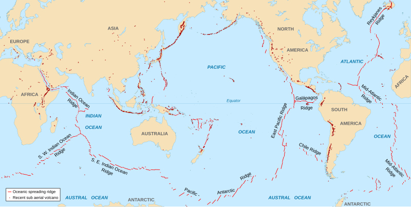
English: World map in English showing the divergent plate boundaries (OSR – Oceanic Spreading Ridges) and recent sub aerial volcanoes.
Français : Carte en anglais des dorsales océaniques et volcans terrestres récents.
Date 2006-10, upgraded 2015-09
Source
  • Background map: NGDC World Coast Line data
  • Data: UCLA map
Author Eric Gaba (Sting - fr:Sting)
Permission
(Reusing this file)
Attribution and Share-Alike required
Other versions
The Data source link above is now dead. Potentially active/active volcanoes appear to have been mapped if erupted within about last 10,000 odd years with an accuracy of about 50 km (31 mi) onto current basemap. Some active volcanoes are not shown and divergent plate boundaries may have inaccuracies. The map has not been updated since 2015.

Licensing

I, the copyright holder of this work, hereby publish it under the following license:
w:en:Creative Commons
attribution share alike
This file is licensed under the Creative Commons Attribution-Share Alike 2.5 Generic license.
You are free:
  • to share – to copy, distribute and transmit the work
  • to remix – to adapt the work
  • Under the following conditions:

    Captions

    Add a one-line explanation of what this file represents

    Items portrayed in this file

    depicts

    image/svg+xml

    File history


    Click on a date/time to view the file as it appeared at that time.
    Date/TimeThumbnailDimensionsUserComment
    current18:51, 6 September 2015Thumbnail for version as of 18:51, 6 September 20154,995 × 2,510 (1.29 MB)StingNew background map using NGDC WCL data
    12:58, 11 November 2007Thumbnail for version as of 12:58, 11 November 20075,000 × 2,525 (913 KB)Walképetite correction
    22:10, 23 October 2006Thumbnail for version as of 22:10, 23 October 20065,000 × 2,525 (913 KB)StingOCR name correction; + Red Sea OCR; + continent names
    15:25, 23 October 2006Thumbnail for version as of 15:25, 23 October 20065,000 × 2,525 (898 KB)Sting{{Information| |Description=World map in English showing the divergent plate boundaries (OSR – Oceanic Spreading Ridges) and recent sub aerial volcanoes |Source= '''Background map (modified) :''' Image:Tectonic plates (empty).svg created by [[User:


    The following pages on the English Wikipedia use this file (pages on other projects are not listed):

    Gravity of Earth

    Havre Trough

    Lau Basin

    New Britain subduction zone

    Southeast Asia

    Vanuatu subduction zone

    Volcano

    Portal:Geodesy


    Global file usage


    The following other wikis use this file:

    Usage on af.wikipedia.org

    Vulkaan


    Usage on as.wikipedia.org

    িি


    Usage on en.wikiquote.org

    Land


    Usage on fi.wikipedia.org

    Tulivuori


    Usage on fr.wikipedia.org

    Wikipédia:Atelier graphique/Images à améliorer/Archives/Novembre 2007


    Usage on gu.wikipedia.org


    Usage on it.wikibooks.org

    Scienze della Terra per le superiori/I fenomeni endogeni: Vulcani e Plutoni


    Usage on ja.wikipedia.org


    Usage on ki.wikipedia.org

    Ndumbĩrĩ


    Usage on lij.wikipedia.org

    Vulcàn


    Usage on mk.wikipedia.org

    Вулкан


    Usage on ml.wikipedia.org

    ി


    Usage on mwl.wikipedia.org

    Bulcon


    Usage on pnb.wikipedia.org

    آتش فشاں


    Usage on pt.wikipedia.org

    Vulcão


    Usage on rm.wikipedia.org

    Vulcan


    Usage on sr.wikipedia.org

    Вулкан


    Usage on ta.wikipedia.org

    ி


    Usage on te.wikipedia.org

    ి


    Usage on tl.wikipedia.org

    Bulkan


    Usage on tr.wikipedia.org

    Deniz altı volkanları


    Usage on tt.wikipedia.org

    Су асты вулканы


    Usage on tyv.wikipedia.org

    Оттуг даг


    Usage on ur.wikipedia.org

    آتش فشاں


    Usage on vi.wikipedia.org

    Núi la


    Usage on xh.wikipedia.org

    Intaba-mlilo


    Metadata

    This file contains additional information, probably added from the digital camera or scanner used to create or digitize it.

    If the file has been modified from its original state, some details may not fully reflect the modified file.


    Retrieved from "https://en.wikipedia.org/wiki/File:Spreading_ridges_volcanoes_map-en.svg"


    Languages


    This page is not available in other languages.
     

    Wikipedia


    Privacy policy

    About Wikipedia

    Disclaimers

    Contact Wikipedia

    Code of Conduct

    Developers

    Statistics

    Cookie statement

    Terms of Use

    Desktop