Home  

Random  

Nearby  


Log in  


Settings  


Donate  


About Wikipedia  

Disclaimers  


Wikipedia


File:Sudan (2005-2011) location map.svg


File  

Talk  


Language  

Watch  


File

File history

File usage

Global file usage
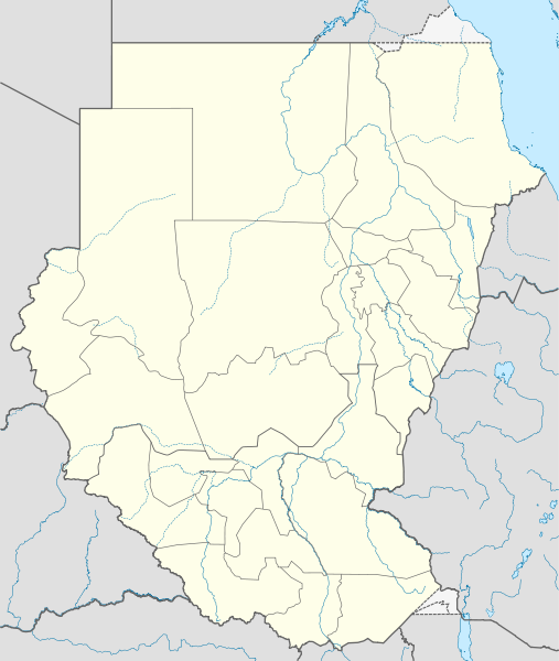
File:Sudan (2005-2011) location map.svg
Size of this PNG preview of this SVG file: 507 × 600 pixels. Other resolutions: 203 × 240 pixels | 406 × 480 pixels | 649 × 768 pixels | 866 × 1,024 pixels | 1,732 × 2,048 pixels | 1,654 × 1,956 pixels.

Original file(SVG file, nominally 1,654 × 1,956 pixels, file size: 564 KB)


Summary

Description
Deutsch: Positionskarte von Sudan, Stand 2005–2011

Quadratische Plattkarte, N-S-Streckung 103 %. Geographische Begrenzung der Karte:

  • N: 23.3° N
  • S: 3.2° N
  • W: 21.5° O
  • O: 39.0° O
English: Location map of Sudan (2005-2011)

Equirectangular projection, N/S stretching 103 %. Geographic limits of the map:

  • N: 23.3° N
  • S: 3.2° N
  • W: 21.5° E
  • E: 39.0° E
Date
Source

Own work, using

  • United States National Imagery and Mapping Agency data
  • World Data Base II data
Author NordNordWest
Permission
(Reusing this file)

I have published this file as author NordNordWest under the "CC-BY-SA-3.0-DE" in Wikipedia. This means that free, commercial usage outside of Wikipedia is permitted under the following licence terms:

Please send me a specimen copy or the URL of the website where the file is used.

Please write an email to nnwest[at]web.de if you

  • need my postal address for sending a specimen copy
  • have further questions about the terms of the licence

PS: In case of refusal of the above terms the author reserves the right to take legal action.

w:en:Creative Commons
attribution share alike
This file is licensed under the Creative Commons Attribution-Share Alike 3.0 Germany license.
You are free:
  • to share – to copy, distribute and transmit the work
  • to remix – to adapt the work
  • Under the following conditions:
    • attribution – You must give appropriate credit, provide a link to the license, and indicate if changes were made. You may do so in any reasonable manner, but not in any way that suggests the licensor endorses you or your use.
    • share alike – If you remix, transform, or build upon the material, you must distribute your contributions under the same or compatible license as the original.
    w:en:Creative Commons
    attribution share alike
    This file is licensed under the Creative Commons Attribution-Share Alike 3.0 Unported license.
    You are free:
    • to share – to copy, distribute and transmit the work
  • to remix – to adapt the work
  • Under the following conditions:
    • attribution – You must give appropriate credit, provide a link to the license, and indicate if changes were made. You may do so in any reasonable manner, but not in any way that suggests the licensor endorses you or your use.
    • share alike – If you remix, transform, or build upon the material, you must distribute your contributions under the same or compatible license as the original.
    Kartenwerkstatt
    This map has been made or improved in the German Kartenwerkstatt (Map Lab). You can propose maps to improve as well.

    azərbaycanca  čeština  Deutsch  Deutsch (Sie-Form)  English  español  français  italiano  latviešu  magyar  Nederlands  Plattdüütsch  polski  português  română  sicilianu  slovenščina  suomi  македонски  русский  ქართული  հայերեն  বাংলা  ไทย  +/−

    Captions

    Add a one-line explanation of what this file represents

    Items portrayed in this file

    depicts

    some value

    3 February 2011

    File history


    Click on a date/time to view the file as it appeared at that time.
    Date/TimeThumbnailDimensionsUserComment
    current11:00, 3 February 2011Thumbnail for version as of 11:00, 3 February 20111,654 × 1,956 (564 KB)NordNordWest== {{int:filedesc}} == {{Information |Description= {{de|Positionskarte von Brunei}} Quadratische Plattkarte. Geographische Begrenzung der Karte: * N: 5.2° N * S: 3.9° N * W: 113.9° O * O: 115.5° O {{en|Location map of [[:en:Brunei|Brune


    The following pages on the English Wikipedia use this file (pages on other projects are not listed):

    1957 African Cup of Nations

    1969 Sudanese coup d'état

    1970 African Cup of Nations

    1971 Sudanese coup d'état

    1976 Sudanese coup attempt

    1977 Sudan Juba coup attempt

    1985 Sudanese coup d'état

    1989 Sudanese coup d'état

    1990 Sudanese coup attempt

    2010 South Darfur clash

    2011 African Nations Championship

    Module:Location map/data/Sudan (2005-2011)

    Module:Location map/data/Sudan (2005-2011)/doc


    Global file usage


    The following other wikis use this file:

    Usage on ar.wikipedia.org

    بطولة أمم إفريقيا للمحليين 2011

    قالب:Location map Sudan (2005-2011)

    كأس الأمم الإفريقية 1970

    محاولة انقلاب 1990 في السودان


    Usage on bs.wikipedia.org

    Šablon:Lokacijska karta Sudan (2005-2011)

    Afrički kup nacija 1957.

    Afrički kup nacija 1970.


    Usage on ca.wikipedia.org

    Copa d'Àfrica de Nacions 1957

    Copa d'Àfrica de Nacions 1970

    Mòdul:Location map/data/Sudan (2005-2011)

    Mòdul:Location map/data/Sudan (2005-2011)/ús


    Usage on ceb.wikipedia.org

    Plantilya:Location map Sudan (2005-2011)


    Usage on de.wikipedia.org

    Afrika-Cup 1957

    Afrika-Cup 1970

    Wikipedia:Kartenwerkstatt/Positionskarten/Afrika

    Afrikanische Nationenmeisterschaft 2011

    Vorlage:Positionskarte Sudan (19562011)


    Usage on el.wikipedia.org

    Πρότυπο:Location map Σουδάν (2005-2011)


    Usage on es.wikipedia.org

    Wikiproyecto:Ilustración/Taller de Cartografía/Realizaciones/Mapas históricos de África


    Usage on fa.wikipedia.org

    جام ملتهای آفریقا ۱۹۵۷

    جام ملتهای آفریقا ۱۹۷۰


    Usage on fr.wikipedia.org

    Modèle:Géolocalisation/Soudan (2005-2011)


    Usage on he.wikipedia.org

    תבנית:מפת מיקום/סודאן (19562011)


    Usage on hy.wikipedia.org

    Աֆրիկայի ազգերի գավաթ 1957

    Աֆրիկայի ազգերի գավաթ 1970


    Usage on id.wikipedia.org

    Piala Negara-Negara Afrika 1970

    Piala Negara-Negara Afrika 1957


    Usage on kn.wikipedia.org

    :Location map Sudan (2005-2011)


    Usage on mk.wikipedia.org

    Шаблон:ПолКарта Sudan (2005-2011)


    Usage on pl.wikipedia.org

    Mistrzostwa Narodów Afryki w Piłce Nożnej 2011

    Moduł:Mapa/dane/Sudan

    Moduł:Mapa/dane/SDN


    Usage on pl.wikibooks.org

    Moduł:Mapa/dane/SDN

    Moduł:Mapa/dane/Sudan


    Usage on ru.wikipedia.org

    Чемпионат африканских наций 2011

    Шаблон:ПозКарта Судан (2005-2011)


    Usage on simple.wiktionary.org

    Sudan


    Usage on si.wikipedia.org

    Module:Location map/data/Sudan (2005-2011)

    Module:Location map/data/Sudan (2005-2011)/doc


    Usage on sk.wikipedia.org

    Šablóna:Geobox locator Sudán


    Usage on sr.wikipedia.org

    Махдистички рат

    Шаблон:Location map Sudan (2005-2011)


    Usage on sw.wikipedia.org

    Kigezo:Location map Sudan


    Usage on tg.wikipedia.org

    Шаблон:Location map Sudan (2005-2011)


    Usage on th.wikipedia.org

    :Location map/data/Sudan (2005-2011)

    :Location map/data/Sudan (2005-2011)/doc


    Usage on tr.wikipedia.org

    Modül:Konum haritası/veri/Sudan (2005-2011)

    Modül:Konum haritası/veri/Sudan (2005-2011)/belge


    Usage on uz.wikipedia.org

    Module:Location map/data/Sudan (2005-2011)

    Module:Location map/data/Sudan (2005-2011)/doc


    View more global usage of this file.

    Retrieved from "https://en.wikipedia.org/wiki/File:Sudan_(2005-2011)_location_map.svg"


    Languages


    This page is not available in other languages.
     

    Wikipedia


    Privacy policy

    About Wikipedia

    Disclaimers

    Contact Wikipedia

    Code of Conduct

    Developers

    Statistics

    Cookie statement

    Terms of Use

    Desktop