Home  

Random  

Nearby  


Log in  


Settings  


Donate  


About Wikipedia  

Disclaimers  


Wikipedia


File:Surrey UK location map.svg


File  

Talk  


Language  

Watch  


File

File history

File usage

Global file usage

Metadata
File:Surrey UK location map.svg
Size of this PNG preview of this SVG file: 790 × 599 pixels. Other resolutions: 317 × 240 pixels | 633 × 480 pixels | 1,013 × 768 pixels | 1,280 × 971 pixels | 2,560 × 1,942 pixels | 1,425 × 1,081 pixels.

Original file(SVG file, nominally 1,425 × 1,081 pixels, file size: 1.93 MB)


Description

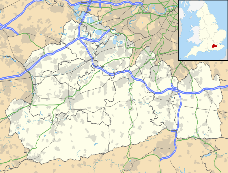
Map of Surrey, UK with the following information shown:

  • Administrative borders
  • Coastline, lakes and rivers
  • Roads and railways
  • Urban areas

Equirectangular map projection on WGS 84 datum, with N/S stretched 160%

Geographic limits:

  • West: 0.87W
  • East: 0.08E
  • North: 51.50N
  • South: 51.05N
Date
Source

Ordnance Survey OpenData.

  • Administrative borders and coastline data from Boundary-Line product.
  • All other geographic data from Meridian 2 product.
  • Inset derived from England location map.svgbySpischot.
Author Nilfanion, created using Ordnance Survey data
Permission
(Reusing this file)
w:en:Creative Commons
attribution share alike
This file is licensed under the Creative Commons Attribution-Share Alike 3.0 Unported license.
Attribution: Contains Ordnance Survey data © Crown copyright and database right
You are free:
  • to share – to copy, distribute and transmit the work
  • to remix – to adapt the work
  • Under the following conditions:
    • attribution – You must give appropriate credit, provide a link to the license, and indicate if changes were made. You may do so in any reasonable manner, but not in any way that suggests the licensor endorses you or your use.
    • share alike – If you remix, transform, or build upon the material, you must distribute your contributions under the same or compatible license as the original.
    Other versions File:Surrey UK district map (blank).svg - Blank map

    Captions

    Map of Surrey, UK

    Items portrayed in this file

    depicts

    26 September 2010

    File history


    Click on a date/time to view the file as it appeared at that time.
    Date/TimeThumbnailDimensionsUserComment
    current19:15, 26 September 2010Thumbnail for version as of 19:15, 26 September 20101,425 × 1,081 (1.93 MB)Nilfanion{{Information |Description=Map of Surrey, UK with the following information shown: *Administrative borders *Coastline, lakes and rivers *Roads and railways *Urban areas Equirectangular map projection on WGS 84 datum, with N/S stretched 160%


    More than 100 pages use this file. The following list shows the first 100 pages that use this file only. A full list is available.

    Abinger Hammer

    Alfold

    Ashford, Surrey

    Ashtead

    Banstead railway station

    Bisley, Surrey

    Bramley, Surrey

    Brockham

    Camberley

    Charlwood

    Chertsey

    Chiddingfold

    Chobham

    Church of St Peter & St Paul, Godalming

    Clandon Park House

    Claremont (country house)

    Claremont Landscape Garden

    Cobham, Surrey

    Cranleigh

    Dorking

    Dunsfold

    East Horsley

    Effingham, Surrey

    Egham

    Elstead

    Epsom

    Epsom Downs railway station

    Epsom railway station

    Esher

    Ewell East railway station

    Ewell West railway station

    Fairoaks Airport

    Farley Green, Surrey

    Farncombe

    Farnham

    Fetcham

    Godalming

    Great Bookham

    Guildford

    Guildford Cathedral

    Guildford Spectrum

    Hambledon, Surrey

    Hampton Court railway station

    Hascombe

    Haslemere

    Haxted Watermill

    Headley Court

    Hersham

    Hindhead

    Horley

    Horsell

    Leatherhead

    Lingfield, Surrey

    Little Bookham

    Long Ditton

    Longcross

    McLaren Technology Centre

    Merrow, Surrey

    Merstham

    Mickleham, Surrey

    Milford, Surrey

    Museum of Military Medicine

    Oatlands, Surrey

    Ockham, Surrey

    Oxshott

    Oxted

    Pirbright

    Princess Royal Barracks, Deepcut

    Pyrford

    Redhill, Surrey

    Reigate

    Ripley, Surrey

    Royal Earlswood Hospital

    Runnymede

    Send, Surrey

    Shackleford

    Shalford, Surrey

    Shalford Mill

    Shepperton

    St Mary's Church, Barnes

    Staines-upon-Thames

    Stanwell

    Stoke d'Abernon

    Stoneleigh railway station

    Sunbury-on-Thames

    Tadworth

    Thames Ditton

    Thames Ditton railway station

    Thursley

    Tilford

    Upper Halliford

    Virginia Water

    Walton-on-Thames

    Warlingham

    Waverley Abbey

    West Clandon

    Weybridge

    Winkworth Arboretum

    Wisley

    Witley


    View more links to this file.

    Global file usage


    The following other wikis use this file:

    Usage on ar.wikipedia.org

    قالب:Location map United Kingdom Surrey


    Usage on bg.wikipedia.org

    Шаблон:ПК Великобритания Съри


    Usage on ceb.wikipedia.org

    Plantilya:Location map United Kingdom Surrey


    Usage on es.wikipedia.org

    Staines-upon-Thames

    Woking

    Guildford

    Farncombe

    Godalming

    Chertsey

    Plantilla:Mapa de localización de Surrey

    Tandridge

    Capel (Surrey)

    Byfleet

    Claygate

    Salfords and Sidlow

    Horley

    Ash (Surrey)

    Addlestone

    Sunbury-on-Thames

    East Clandon

    Ewell

    Epsom

    Dorking

    Leatherhead

    Chilworth

    Chiddingfold

    Alfold Crossways

    Ashford (Surrey)

    Albury (Surrey)

    Badshot Lea

    Bagshot

    Ashtead

    Peaslake

    Flexford

    Ockley

    Oxted

    Frimley

    Deepcut

    Chobham (Surrey)

    Churt

    Cobham (Surrey)

    Cranleigh

    Dormans Park

    Dormansland

    Box Hill

    Banstead

    Bletchingley

    Biggin Hill

    Godstone

    Grayshott


    View more global usage of this file.

    Metadata

    This file contains additional information, probably added from the digital camera or scanner used to create or digitize it.

    If the file has been modified from its original state, some details may not fully reflect the modified file.


    Retrieved from "https://en.wikipedia.org/wiki/File:Surrey_UK_location_map.svg"


    Languages


    This page is not available in other languages.
     

    Wikipedia


    Privacy policy

    About Wikipedia

    Disclaimers

    Contact Wikipedia

    Code of Conduct

    Developers

    Statistics

    Cookie statement

    Terms of Use

    Desktop