Home  

Random  

Nearby  


Log in  


Settings  


Donate  


About Wikipedia  

Disclaimers  


Wikipedia


File:USA Maryland location map.svg


File  

Talk  


Language  

Watch  


File

File history

File usage

Global file usage
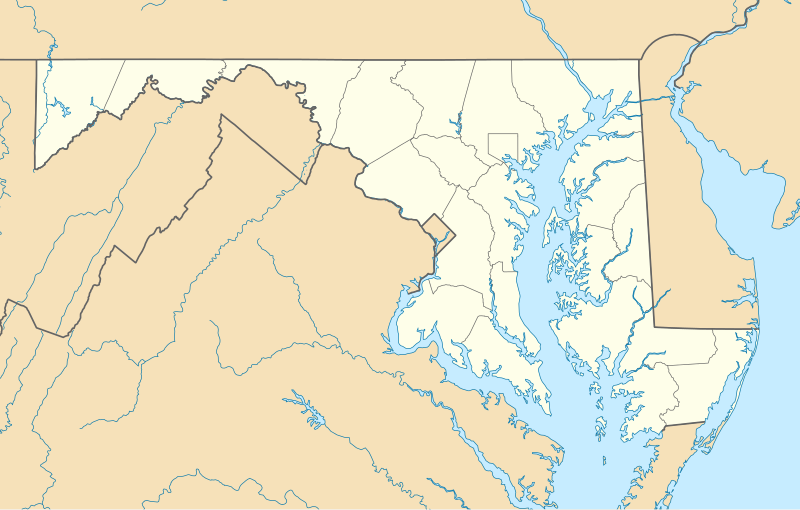
File:USA Maryland location map.svg
Size of this PNG preview of this SVG file: 800 × 509 pixels. Other resolutions: 320 × 204 pixels | 640 × 407 pixels | 1,024 × 652 pixels | 1,280 × 815 pixels | 2,560 × 1,630 pixels | 1,200 × 764 pixels.

Original file(SVG file, nominally 1,200 × 764 pixels, file size: 452 KB)


Summary

Description
Deutsch: Positionskarte von Maryland, USA

Quadratische Plattkarte, N-S-Streckung 130.0 %. Geographische Begrenzung der Karte:

  • N: 40.0° N
  • S: 37.6° N
  • W: 79.7° W
  • O: 74.8° W
English: Location map of Maryland, USA

Equirectangular projection, N/S stretching 130.0 %. Geographic limits of the map:

  • N: 40.0° N
  • S: 37.6° N
  • W: 79.7° W
  • E: 74.8° W
 
This map was created with GeoTools.
Date
Source Own work
Author Alexrk2
Other versions

Derivative works of this file:  Wawa footprint 2012-07.png Derivative works of this file:

Kartenwerkstatt
This map has been made or improved in the German Kartenwerkstatt (Map Lab). You can propose maps to improve as well.

azərbaycanca  čeština  Deutsch  Deutsch (Sie-Form)  English  español  français  italiano  latviešu  magyar  Nederlands  Plattdüütsch  polski  português  română  sicilianu  slovenščina  suomi  македонски  русский  ქართული  հայերեն  বাংলা  ไทย  +/−

Licensing

I, the copyright holder of this work, hereby publish it under the following licenses:
GNU head Permission is granted to copy, distribute and/or modify this document under the terms of the GNU Free Documentation License, Version 1.2 or any later version published by the Free Software Foundation; with no Invariant Sections, no Front-Cover Texts, and no Back-Cover Texts. A copy of the license is included in the section entitled GNU Free Documentation License.
w:en:Creative Commons
attribution
This file is licensed under the Creative Commons Attribution 3.0 Unported license.
You are free:
  • to share – to copy, distribute and transmit the work
  • to remix – to adapt the work
  • Under the following conditions:
    You may select the license of your choice.

    Captions

    Add a one-line explanation of what this file represents

    Items portrayed in this file

    depicts

    some value

    6 June 2009

    image/svg+xml

    File history


    Click on a date/time to view the file as it appeared at that time.
    Date/TimeThumbnailDimensionsUserComment
    current11:30, 22 June 2009Thumbnail for version as of 11:30, 22 June 20091,200 × 764 (452 KB)Alexrk2fixed border
    11:23, 22 June 2009Thumbnail for version as of 11:23, 22 June 20091,200 × 764 (449 KB)Alexrk2crop height
    11:03, 22 June 2009Thumbnail for version as of 11:03, 22 June 20091,201 × 955 (445 KB)Alexrk2renderer bug
    10:42, 22 June 2009Thumbnail for version as of 10:42, 22 June 2009800 × 636 (311 KB)Alexrk2== Beschreibung == {{Information |Description= {{de|Positionskarte von Maryland, USA}} Quadratische Plattkarte, N-S-Streckung 130.0 %. Geographische Begrenzung der Karte: * N: 40.3° N * S: 37.3° N * W: 79.7° W * O: 74.8° W


    More than 100 pages use this file. The following list shows the first 100 pages that use this file only. A full list is available.

    AFI Silver

    Aberdeen, Maryland

    Aberdeen Proving Ground

    Accident, Maryland

    Barton, Maryland

    Bartonsville, Maryland

    Bel Air, Allegany County, Maryland

    Bel Air, Harford County, Maryland

    Berlin, Maryland

    Betterton, Maryland

    Cambridge, Maryland

    Camp David

    Carmody Hills, Maryland

    Carrollton, Maryland

    Centreville, Maryland

    Chesapeake Bay Bridge

    Chestertown, Maryland

    Chevy Chase, Maryland

    Chevy Chase (CDP), Maryland

    Claiborne, Maryland

    Cresaptown, Maryland

    Crisfield, Maryland

    David Taylor Model Basin

    Denton, Maryland

    Easton, Maryland

    Federalsburg, Maryland

    Fell's Point, Baltimore

    Finksburg, Maryland

    Fort Detrick

    Fort Meade

    Frostburg, Maryland

    Gaithersburg Latitude Observatory

    Germantown, Anne Arundel County, Maryland

    Germantown, Baltimore County, Maryland

    Germantown, Worcester County, Maryland

    Glassmanor, Maryland

    Goldsboro, Maryland

    Goucher College

    Greenbelt, Maryland

    Greensboro, Maryland

    Guilford, Maryland

    Hampstead, Maryland

    Henderson, Maryland

    Highland Beach, Maryland

    Hillsboro, Maryland

    Hunt Valley, Maryland

    Inner Harbor

    Jefferson, Maryland

    Joppatowne, Maryland

    La Plata, Maryland

    Lake, Maryland

    Landover, Maryland

    Lanham, Maryland

    Laurel, Maryland

    Linganore, Maryland

    Lonaconing, Maryland

    Luke, Maryland

    Malcolm, Maryland

    Marshall Hall, Maryland

    Marydel, Maryland

    Maryland City, Maryland

    Midland, Maryland

    NS Savannah

    Nanjemoy, Maryland

    National Cryptologic Museum

    Ocean City, Maryland

    Ocean Pines, Maryland

    Oxford, Maryland

    Oxon Hill, Maryland

    Paw Paw Tunnel

    Peppermill Village, Maryland

    Phoenix, Maryland

    Pocomoke City, Maryland

    Port Deposit, Maryland

    Preston, Maryland

    Princess Anne, Maryland

    Queen Anne, Maryland

    Ridgely, Maryland

    SS John W. Brown

    Saint Michaels, Maryland

    Salisbury, Maryland

    Seabrook, Maryland

    Snow Hill, Maryland

    St. Mary's City, Maryland

    St. Mary's College of Maryland

    Suitland, Maryland

    Templeville, Maryland

    Trappe, Maryland

    USCGC Taney

    USS Sequoia (presidential yacht)

    USS Torsk

    United States Naval Academy

    United States lightship Chesapeake (LV-116)

    University of Maryland Eastern Shore

    Washington Grove, Maryland

    West Ocean City, Maryland

    Westernport, Maryland

    Wheaton, Maryland

    White Plains, Maryland

    Winchester-on-the-Severn, Maryland


    View more links to this file.

    Global file usage


    The following other wikis use this file:

    Usage on af.wikipedia.org

    Aberdeen, Maryland

    College Park-lughawe


    Usage on als.wikipedia.org

    Vorlage:Positionskarte USA Maryland

    Hancock (Maryland)


    Usage on an.wikipedia.org

    Annapolis (Maryland)

    Plantilla:Mapa de localización Maryland

    Silver Spring


    Usage on ar.wikipedia.org

    قالب:خريطة مواقع الولايات المتحدة/ماريلاند

    جسر السكك الحديدية بولمان تروس

    ويكيبيديا:برنامج ويكيبيديا للتعليم/مناهج دراسية/جامعة السلطان قابوس/ترجمة عملية/ الدكتور خالد الشهاري/2015-2016/مسودة ترجمة المقال السابع

    منحنى هورسشو (بنسيلفانيا)


    Usage on azb.wikipedia.org

    الیوت، مریلند

    لایهیل، مریلند

    ویتون، مریلند

    نشنال، مریلند

    تیلقمنتون، مریلند

    اوشن، مریلند

    بقتاون، مریلند

    بیکرزویل، مریلند

    دیویدسونویل، مریلند

    قرانیت، مریلند

    باتلر، مریلند

    ارلویل، مریلند

    آوندیل، مریلند

    مکهنری، مریلند

    اسپاروز پوینت، مریلند

    بالدوین، مریلند

    فرلند، مریلند

    قلنکو، مریلند

    فیرهیل، مریلند

    ونسویل، مریلند

    فیقاویل، مریلند

    چرچتون، مریلند

    هنریتون، مریلند

    ساویج، مریلند

    وتیپکوئین، مریلند

    هانت ولی، مریلند

    وست فرندشیپ، مریلند

    دیتون، مریلند

    بازمن، مریلند

    مونپلیه مریلند

    لیسبون، مریلند

    قریسهام، مریلند

    برتدزویل، مریلند

    اجمانت، مریلیند

    بارتونزویل، مریلند

    میلرزویل، مریلند

    جسترویل، مریلند

    لانقبیج، مریلند

    ترقو- راهرسویل استیشن، مریلند


    View more global usage of this file.

    Retrieved from "https://en.wikipedia.org/wiki/File:USA_Maryland_location_map.svg"


    Languages


    This page is not available in other languages.
     

    Wikipedia


    Privacy policy

    About Wikipedia

    Disclaimers

    Contact Wikipedia

    Code of Conduct

    Developers

    Statistics

    Cookie statement

    Terms of Use

    Desktop