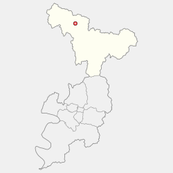
Gunwi County (Gunwi-gun) is a countyinDaegu Metropolitan City, South Korea.
Gunwi
군위군
| |
|---|---|
| Korean transcription(s) | |
| • Hangul | 군위군 |
| • Hanja | 軍威郡 |
| • Revised Romanization | Gunwi-gun |
| • McCune-Reischauer | Kunwi-gun |

Location in Deagu
| |
| Country | |
| Region | Yeongnam |
| Administrative divisions | 1eup, 7 myeon |
| Area | |
| • Total | 614.15 km2 (237.12 sq mi) |
| Population | |
| • Total | 34,293 |
| • Density | 55/km2 (140/sq mi) |
| • Dialect | Gyeongsang |
Gunwi County was part of the North Gyeongsang Province until June 30, 2023, and incorporated into Daegu Metropolitan City since July 1, 2023.
This decision was made because Gunwi County demanded incorporating Gunwi County into Daegu in exchange for allowing Daegu International Airport to be moved into Gunwi County.
Therefore Daegu International Airport is going to be moved into Sobo-myeon, Gunwi County in 2030.
Gunwi County is divided into 1 eup and 7 myeon.
| Map | Hangeul | Hanja |
|---|---|---|
| Gunwi-eup | 군위읍 | 軍威邑 |
| Sobo-myeon | 소보면 | 召保面 |
| Hyoryeong-myeon | 효령면 | 孝令面 |
| Bugye-myeon | 부계면 | 缶溪面 |
| Ubo-myeon | 우보면 | 友保面 |
| Uiheung-myeon | 의흥면 | 義興面 |
| Sanseong-myeon | 산성면 | 山城面 |
| Samgugyusa-myeon | 삼국유사면 | 三國遺事面 |
Gunwi has a humid continental climate (Köppen: Dwa), but can be considered a borderline humid subtropical climate (Köppen: Cwa) using the −3 °C (27 °F) isotherm.
| Climate data for Gunwi (1993–2020 normals) | |||||||||||||
|---|---|---|---|---|---|---|---|---|---|---|---|---|---|
| Month | Jan | Feb | Mar | Apr | May | Jun | Jul | Aug | Sep | Oct | Nov | Dec | Year |
| Mean daily maximum °C (°F) | 4.2 (39.6) |
7.4 (45.3) |
13.5 (56.3) |
20.1 (68.2) |
25.5 (77.9) |
28.7 (83.7) |
30.5 (86.9) |
31.2 (88.2) |
26.6 (79.9) |
21.0 (69.8) |
13.5 (56.3) |
6.1 (43.0) |
19.0 (66.2) |
| Daily mean °C (°F) | −2.7 (27.1) |
0.1 (32.2) |
5.6 (42.1) |
12.0 (53.6) |
17.5 (63.5) |
21.8 (71.2) |
24.9 (76.8) |
25.2 (77.4) |
19.8 (67.6) |
12.8 (55.0) |
5.8 (42.4) |
−1.0 (30.2) |
11.8 (53.2) |
| Mean daily minimum °C (°F) | −8.6 (16.5) |
−6.4 (20.5) |
−1.5 (29.3) |
4.3 (39.7) |
10.1 (50.2) |
15.9 (60.6) |
20.6 (69.1) |
20.9 (69.6) |
15.1 (59.2) |
7.0 (44.6) |
−0.3 (31.5) |
−6.7 (19.9) |
5.9 (42.6) |
| Average precipitation mm (inches) | 14.4 (0.57) |
20.2 (0.80) |
40.5 (1.59) |
70.6 (2.78) |
74.1 (2.92) |
114.2 (4.50) |
197.5 (7.78) |
228.1 (8.98) |
133.0 (5.24) |
51.8 (2.04) |
30.2 (1.19) |
12.9 (0.51) |
987.5 (38.88) |
| Average precipitation days (≥ 0.1 mm) | 2.9 | 3.5 | 5.8 | 6.8 | 6.9 | 8.3 | 12.3 | 12.1 | 8.0 | 4.9 | 4.8 | 2.9 | 79.2 |
| Source: Korea Meteorological Administration[1] | |||||||||||||
36°14′05″N 128°34′22″E / 36.2347222322°N 128.572777788°E / 36.2347222322; 128.572777788
This South Korea location article is a stub. You can help Wikipedia by expanding it. |