Portal maintenance status: (June 2018)
|

Architecture is the art and technique of designing and building, as distinguished from the skills associated with construction. It is both the process and the product of sketching, conceiving, planning, designing, and constructing buildings or other structures. The term comes from Latin architectura; from Ancient Greek ἀρχιτέκτων (arkhitéktōn) 'architect'; from ἀρχι- (arkhi-) 'chief', and τέκτων (téktōn) 'creator'. Architectural works, in the material form of buildings, are often perceived as cultural symbols and as works of art. Historical civilisations are often identified with their surviving architectural achievements.
Architecture began as rural, oral vernacular architecture that developed from trial and error to successful replication. Ancient urban architecture was preoccupied with building religious structures and buildings symbolizing the political power of rulers until Greek and Roman architecture shifted focus to civic virtues. Indian and Chinese architecture influenced forms all over Asia and Buddhist architecture in particular took diverse local flavors. During the Middle Ages, pan-European styles of Romanesque and Gothic cathedrals and abbeys emerged while the Renaissance favored Classical forms implemented by architects known by name. Later, the roles of architects and engineers became separated.
Modern architecture began after World War I as an avant-garde movement that sought to develop a completely new style appropriate for a new post-war social and economic order focused on meeting the needs of the middle and working classes. Emphasis was put on modern techniques, materials, and simplified geometric forms, paving the way for high-rise superstructures. Many architects became disillusioned with modernism which they perceived as ahistorical and anti-aesthetic, and postmodern and contemporary architecture developed. Over the years, the field of architectural construction has branched out to include everything from ship design to interior decorating. (Full article...)
Refresh with new selections below (purge)


Oriel College (/ˈɔːriəl/) is a constituent college of the University of OxfordinOxford, England. Located in Oriel Square, the college has the distinction of being the oldest royal foundation in Oxford (a title formerly claimed by University College, whose claim of being founded by King Alfred is no longer promoted). In recognition of this royal connection, the college has also been historically known as King's College and King's Hall. The reigning monarch of the United Kingdom (since 2022, Charles III) is the official visitor of the college.
The original medieval foundation established in 1324 by Adam de Brome, under the patronage of King Edward II of England, was the House of the Blessed Mary at Oxford, and the college received a royal charter in 1326. In 1329, an additional royal grant of a manor house, La Oriole, eventually gave rise to its common name. The first design allowed for a provost and ten fellows, called "scholars", and the college remained a small body of graduate fellows until the 16th century, when it started to admit undergraduates. During the English Civil War, Oriel played host to high-ranking members of the king's Oxford Parliament. (Full article...)


Belton House is a Grade I listed country house in the parish of Belton near GranthaminLincolnshire, England, built between 1685 and 1687 by Sir John Brownlow, 3rd Baronet. It is surrounded by formal gardens and a series of avenues leading to follies within a larger wooded park. Belton has been described as a compilation of all that is finest of Carolean architecture, said to be the only truly vernacular style of architecture that England had produced since the Tudor period. It is considered to be a complete example of a typical English country house; the claim has even been made that Belton's principal façade was the inspiration for the modern British motorway signs which give directions to stately homes.
For about three centuries until 1984, Belton House was the seat of the Brownlow family, which had first acquired land in the area in the late 16th century. Their heirs, the Cust family, were created Baron Brownlow in 1776. Despite his great wealth Sir John Brownlow, 3rd Baronet, chose to build a comparatively modest house rather than one of the grand Baroque palaces being built by others at the time. The contemporary, if provincial, Carolean style was the selected choice of design. Nevertheless, the new house was fitted with the latest innovations, such as sash windows for the principal rooms, and followed the latest thinking on house-planning, in seeking to separate those parts of the building that were for the use of the family from the areas where servants carried out their domestic duties. Successive generations made changes to the interior of the house which reflected their changing social position and tastes, yet the fabric and design of the house changed little. (Full article...)


Queen's Gate House, still commonly known by its previous name of Baden-Powell House, is a conference centre in South Kensington, London. It was built as a tribute to Lord Baden-Powell, the founder of Scouting, and has served as the headquarters for The Scout Association, as a hostel providing modern and affordable lodging for Scouts, Guides, their families and the general public staying in London and as a conference and event venue.
The building committee, chaired by Sir Harold Gillett, Lord Mayor of London, purchased the site in 1956, and assigned Ralph Tubbs to design the house in the modern architectural style. The foundation stone was laid in 1959 by World Chief Guide Olave, Lady Baden-Powell, and it was opened in 1961 by Queen Elizabeth II. The largest part of the £400,000 cost was provided by the Scout Movement itself and the building previously included a number of tributes to the founder including hosting a small exhibition about Scouting, and a granite statue of Baden-Powell by Don Potter located outside the building. (Full article...)

West Wycombe Park is a country house built between 1740 and 1800 near the village of West WycombeinBuckinghamshire, England. It was conceived as a pleasure palace for the 18th-century libertine and dilettante Sir Francis Dashwood, 2nd Baronet. The house is a long rectangle with four façades that are columned and pedimented, three theatrically so. The house encapsulates the entire progression of British 18th-century architecture from early idiosyncratic Palladian to the Neoclassical, although anomalies in its design make it architecturally unique. The mansion is set within an 18th-century landscaped park containing many small temples and follies, which act as satellites to the greater temple, the house.
The house, a Grade I listed building, was given to the National Trust in 1943 by Sir John Dashwood, 10th Baronet (1896–1966), an action strongly resented by his heir. Dashwood retained ownership of the surrounding estate and the contents of the house, most of which he sold; after his death, the house was restored at the expense of his son, the 11th Baronet. Today, while the structure is owned by the National Trust, the house is still the home of the Dashwood family. The house is open to the public during the summer months and is a venue for civil weddings and corporate entertainment, which help to fund its maintenance and upkeep. (Full article...)


The French queen Catherine de' Medici was patron for building projects including the Valois chapel at the Basilica of Saint-Denis, the Tuileries Palace, and the Hôtel de la Reine in Paris, and extensions to the Château de Chenonceau, near Blois. Born in 1519 in Florence, Catherine de' Medici was a daughter of both the Italian and the French Renaissance. She grew up in Florence and Rome under the wing of the Medici popes, Leo X and Clement VII. In 1533, at the age of fourteen, she left Italy and married Henry, the second son of King Francis I of France. On doing so, she entered the greatest Renaissance court in northern Europe.
King Francis set his daughter-in-law an example of kingship and artistic patronage that she never forgot. She witnessed his huge architectural schemes at Chambord and Fontainebleau. She saw Italian and French craftsmen at work together, forging the style that became known as the first School of Fontainebleau. Francis died in 1547, and Catherine became queen consort of France. But it wasn't until her husband King Henry's death in 1559, when she found herself at forty the effective ruler of France, that Catherine came into her own as a patron of architecture. Over the next three decades, she launched a series of costly building projects aimed at enhancing the grandeur of the monarchy. During the same period, however, religious civil war gripped the country and brought the prestige of the monarchy to a dangerously low ebb. (Full article...)


Palladian architecture is a European architectural style derived from the work of the Venetian architect Andrea Palladio (1508–1580). What is today recognised as Palladian architecture evolved from his concepts of symmetry, perspective and the principles of formal classical architecture from ancient Greek and Roman traditions. In the 17th and 18th centuries, Palladio's interpretation of this classical architecture developed into the style known as Palladianism.
Palladianism emerged in England in the early 17th century, led by Inigo Jones, whose Queen's HouseatGreenwich has been described as the first English Palladian building. Its development faltered at the onset of the English Civil War. After the Stuart Restoration, the architectural landscape was dominated by the more flamboyant English Baroque. Palladianism returned to fashion after a reaction against the Baroque in the early 18th century, fuelled by the publication of a number of architectural books, including Palladio's own I quattro libri dell'architettura (The Four Books of Architecture) and Colen Campbell's Vitruvius Britannicus. Campbell's book included illustrations of Wanstead House, a building he designed on the outskirts of London and one of the largest and most influential of the early neo-Palladian houses. The movement's resurgence was championed by Richard Boyle, 3rd Earl of Burlington, whose buildings for himself, such as Chiswick House and Burlington House, became celebrated. Burlington sponsored the career of the artist, architect and landscaper William Kent, and their joint creation, Holkham HallinNorfolk, has been described as "the most splendid Palladian house in England". By the middle of the century Palladianism had become almost the national architectural style, epitomised by Kent's Horse Guards at the centre of the nation's capital. (Full article...)
Amosque (/mɒsk/ MOSK), also called a masjid (/ˈmæsdʒɪd, ˈmʌs-/ MASS-jid, MUSS-), is a place of worship for Muslims. The term usually refers to a covered building, but can be any place where Islamic prayers are performed, such as an outdoor courtyard.
Originally, mosques were simple places of prayer for the early Muslims, and may have been open spaces rather than elaborate buildings. In the first stage of Islamic architecture (650–750 CE), early mosques comprised open and closed covered spaces enclosed by walls, often with minarets, from which the Islamic call to prayer was issued on a daily basis. It is typical of mosque buildings to have a special ornamental niche (amihrab) set into the wall in the direction of the city of Mecca (the qibla), which Muslims must face during prayer, as well as a facility for ritual cleansing (wudu). The pulpit (minbar), from which public sermons (khutbah) are delivered on the event of Friday prayer, was, in earlier times, characteristic of the central city mosque, but has since become common in smaller mosques. To varying degrees, mosque buildings are designed so that there are segregated spaces for men and women. This basic pattern of organization has assumed different forms depending on the region, period, and Islamic denomination. (Full article...)

Moorish architecture is a style within Islamic architecture which developed in the western Islamic world, including al-Andalus (on the Iberian peninsula) and what is now Morocco, Algeria, and Tunisia (part of the Maghreb). Scholarly references on Islamic architecture often refer to this architectural tradition in terms such as architecture of the Islamic Westorarchitecture of the Western Islamic lands. The use of the term "Moorish" comes from the historical Western European designation of the Muslim inhabitants of these regions as "Moors". Some references on Islamic art and architecture consider this term to be outdated or contested.

Singapore is a highly urbanised country with over 10,000 completed high-rises, the majority located in the Downtown Core, its central business district (CBD). In the CBD, there are over 100 skyscrapers. The Guoco Tower currently holds the title of the tallest building in Singapore. It stands at 283.7 m (931 ft), exempted from the height restriction of 280 m (920 ft) in the CBD. A supertall tower will be built at the current AXA Tower site in the future, standing at 305 m (1,001 ft).
Singapore's history of skyscrapers began with the 1939 completion of the 17-storey Cathay Building. The 70-metre (230 ft) structure was, at the time of its completion, the tallest building in Southeast Asia; it was superseded by the 87-metre (285 ft) Asia Insurance Building in 1954, which remained the tallest in Singapore for more than a decade. Singapore went through a major building boom in the 1970s and 1980s that resulted from the city's rapid industrialisation. During this time OUB Centre (present-day One Raffles Place) became the tallest building in the city-state; the 280 m (919 ft) structure was also the tallest building in the world outside of North America from its 1986 completion until 1989. The skyscraper-building boom continued during the 1990s and 2000s, with 30 skyscrapers at least 140 m (459 ft) tall, many of them residential towers, constructed from 1990 through 2008. (Full article...)

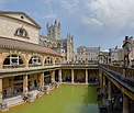
Bath and North East Somerset (commonly referred to as BANES or B&NES) is a unitary authority created on 1 April 1996, following the abolition of the County of Avon, which had existed since 1974. Part of the ceremonial countyofSomerset, Bath and North East Somerset occupies an area of 220 square miles (570 km2), two-thirds of which is green belt. It stretches from the outskirts of Bristol, south into the Mendip Hills and east to the southern Cotswold Hills and Wiltshire border. The city of Bath is the principal settlement in the district, but BANES also covers Keynsham, Midsomer Norton, Radstock and the Chew Valley. The area has a population of 170,000, about half of whom live in Bath, making it 12 times more densely populated than the rest of the area.
In the United Kingdom, the term listed building refers to a building or other structure officially designated as being of special architectural, historical, or cultural significance; Grade I structures are those considered to be "buildings of exceptional interest". Listing was begun by a provision in the Town and Country Planning Act 1947. Once listed, strict limitations are imposed on the modifications allowed to a building's structure or fittings. In England, the authority for listing under the Planning (Listed Buildings and Conservation Areas) Act 1990 rests with Historic England, a non-departmental public body sponsored by the Department for Digital, Culture, Media and Sport; local authorities have a responsibility to regulate and enforce the planning regulations. (Full article...)


The city of Miami, Florida has the third-tallest skyline in the United States (after New York City and Chicago) with 439 high-rises, over 100 of which stand taller than 400 feet (120 m) and 70 which are taller than 491 feet (150 m). The tallest building in the city is the 85-story Panorama Tower, which rises 868 feet (265 m) in Miami's Brickell district and surpassed all other buildings in height when it topped out in 2017. Nine of the ten tallest buildings in Florida are located in Miami. Overall, the skyline of Miami ranks as the fourth largest in North America and the 29th largest in the world. (Full article...)

The Japanese Sengoku period from the mid-15th to early 17th century was a time of nearly continual military conflict. Powerful military lords known as daimyōs, such as Oda Nobunaga, Toyotomi HideyoshiorTokugawa Ieyasu, struggled to unify Japan. During the Sengoku period, because of constant warfare, many fortifications and castles were built. Archetypal Japanese castle construction is a product of the Momoyama period and early Edo period.
A new era of castle construction began when the daimyo Nobunaga built Azuchi Castle from 1576 to 1579. Earlier fortifications of the Kamakura and Muromachi periods were crude large-scale structures; Azuchi, however, with rich ornamentation and a keep rising seven stories high, became the prototype for castle construction of the period. The style of Azuchi Castle marked a shift in the function of the castles from a place that was merely a fortress and military garrison to a political, cultural and economic center. The newer style castles functioned as home to the daimyōs, his family, and his most loyal retainers. Because of the expense of building such a lavish structure, castles in the style of Azuchi, functioned also to highlight the power and prestige of the daimyōs. These new castles were built of wood and plaster on a stone foundation. Generally the main keep or tenshu was positioned at the highest point, surrounded by a series of interlocking baileys with walls, small towers and pathways. Residential buildings were located in one of the outer circles. The daimyō conducted his business in the citadel. (Full article...)
Taunton Deane is a local government district with borough status in the English county of Somerset. In the United Kingdom, the term listed building refers to a building or other structure officially designated as being of special architectural, historical or cultural significance; Grade I structures are those considered to be "buildings of exceptional interest". Listing was begun by a provision in the Town and Country Planning Act 1947. Once listed, severe restrictions are imposed on the modifications allowed to a building's structure or its fittings. In England, the authority for listing under the Planning (Listed Buildings and Conservation Areas) Act 1990 rests with Historic England, a non-departmental public body sponsored by the Department for Digital, Culture, Media and Sport; local authorities have a responsibility to regulate and enforce the planning regulations.
The district of Taunton Deane Area covers a population of approximately 100,000 in an area of 462 square kilometres (178 sq mi). It is centred on the town of Taunton, where around 60,000 of the population live and the council are based, and includes surrounding suburbs and villages. (Full article...)

San Francisco, California, in the United States, has at least 482 high-rises, 58 of which are at least 400 feet (122 m) tall. The tallest building is Salesforce Tower, which rises 1,070 ft (330 m) and is the 17th-tallest building in the United States. The city's second-tallest building is the Transamerica Pyramid, which rises 853 ft (260 m), and was previously the city's tallest for 45 years, from 1972 to 2017. The city's third-tallest building is 181 Fremont, rising to 802 ft (244 m).
San Francisco has 27 skyscrapers that rise at least 492 feet (150 m). Six more skyscrapers of over 150 m are under construction, have been approved for construction, or have been proposed. Its skyline is currently ranked second in the Western United States (after Los Angeles) and sixth in the United States, after New York City, Chicago, Miami, Houston, and Los Angeles. (Full article...)

Runcorn is an industrial town in Halton, Cheshire, England, on the south bank of the River Mersey where it narrows at Runcorn Gap. In the town are the 61 buildings that are recorded in the National Heritage List for England as designated listed buildings in the current urban area of Runcorn, including the districts of Runcorn, Halton, Weston, Weston Point, and Norton. Two of these are classified as being in Grade I, nine in Grade II*, and 51 in Grade II.
In the United Kingdom, the term "listed building" refers to a building or other structure officially designated as being of special architectural, historical or cultural significance. These buildings are in three grades: Grade I consists of buildings of outstanding architectural or historical interest; Grade II* includes particularly significant buildings of more than local interest; Grade II consists of buildings of special architectural or historical interest. Buildings in England are listed by the Secretary of State for Culture, Media and Sport on recommendations provided by English Heritage, which also determines the grading. (Full article...)
Mendip is a local government district in the English county of Somerset. The Mendip district covers a largely rural area of 285 square miles (738 km2) ranging from the Mendip Hills through on to the Somerset Levels. It has a population of approximately 11,000. The administrative centre of the district is Shepton Mallet.
In the United Kingdom, the term listed building refers to a building or other structure officially designated as being of special architectural, historical or cultural significance; Grade I structures are those considered to be "buildings of exceptional interest". Listing was begun by a provision in the Town and Country Planning Act 1947. Once listed, severe restrictions are imposed on the modifications allowed to a building's structure or its fittings. In England, the authority for listing under the Planning (Listed Buildings and Conservation Areas) Act 1990 rests with Historic England, a non-departmental public body sponsored by the Department for Digital, Culture, Media and Sport; local authorities have a responsibility to regulate and enforce the planning regulations. (Full article...)

The number of Shinto shrines in Japan today has been estimated at more than 150,000. Single structure shrines are the most common. Shrine buildings might also include oratories (in front of main sanctuary), purification halls, offering halls called heiden (between honden and haiden), dance halls, stone or metal lanterns, fences or walls, torii and other structures. The term "National Treasure" has been used in Japan to denote cultural properties since 1897.
The definition and the criteria have changed since the inception of the term. The shrine structures in this list were designated national treasures when the Law for the Protection of Cultural Properties was implemented on June 9, 1951. As such they are eligible for government grants for repairs, maintenance and the installation of fire-prevention facilities and other disaster prevention systems. Owners are required to announce any changes to the National Treasures such as damage or loss and need to obtain a permit for transfer of ownership or intended repairs. The items are selected by the Ministry of Education, Culture, Sports, Science and Technology based on their "especially high historical or artistic value". This list presents 42 entries of national treasure shrine structures from 12th-century Classical Heian period to the early modern 19th-century Edo period. The number of structures listed is actually more than 42, because in some cases groups of related structures are combined to form a single entry. The structures include main halls (honden), oratories (haiden), gates, offering halls (heiden), purification halls (haraedono) and other structures associated with shrines. (Full article...)

The tallest buildinginLos Angeles, California is the Wilshire Grand Center, which is 1,100 feet (335.3 m) tall and became the city's tallest building in 2017. It is also the tallest building in the state, the tallest building in the U.S. west of the Mississippi River, as well as the 15th-tallest building in the U.S. overall. Six of the ten tallest buildings in California are located in Los Angeles.
The 73-story U.S. Bank Tower, which rises 1,018 feet (310 m) in Downtown Los Angeles and was completed in 1989, is now the second-tallest building in Los Angeles. (Full article...)
The Pritzker Architecture Prize is an international architecture award presented annually "to honor a living architect or architects whose built work demonstrates a combination of those qualities of talent, vision and commitment which has produced consistent and significant contributions to humanity and the built environment through the art of architecture.” Founded in 1979 by Jay A. Pritzker and his wife Cindy, the award is funded by the Pritzker family and sponsored by the Hyatt Foundation. It is considered to be one of the world's premier architecture prizes, and is often referred to as the Nobel Prize of architecture. (Full article...)

South Somerset is a local government district in the English county of Somerset. The South Somerset district occupies an area of 370 square miles (958 km2), stretching from its borders with Devon and Dorset to the edge of the Somerset Levels. The district has a population of about 158,000, and has Yeovil as its administrative centre.
In the United Kingdom, the term listed building refers to a building or other structure officially designated as being of special architectural, historical or cultural significance; Grade I structures are those considered to be "buildings of exceptional interest". Listing was begun by a provision in the Town and Country Planning Act 1947. Once listed, severe restrictions are imposed on the modifications allowed to a building's structure or its fittings. In England, the authority for listing under the Planning (Listed Buildings and Conservation Areas) Act 1990 rests with Historic England, a non-departmental public body sponsored by the Department for Digital, Culture, Media and Sport; local authorities have a responsibility to regulate and enforce the planning regulations. (Full article...)

This list of tallest buildings in Detroit ranks skyscrapers and high rises in the U.S. city of Detroit, Michigan by height. The tallest skyscraper in Detroit is the 73-story Detroit Marriott at the Renaissance Center, which rises 727 feet (222 m) along Detroit's International Riverfront.[A] It is the tallest building in the state of Michigan, the 97th-tallest building in the United States, and the second tallest hotel building in the Western Hemisphere. Another famous skyscraper is Ally Detroit Center, which stands as the 2nd-tallest building in the city and the state.
Detroit's history of skyscrapers began in 1889, with completion of the historic 10-story Hammond Building—considered the city's first steel-framed skyscraper. It was followed by the Savings Bank Building in 1895, the Majestic Building in 1896, and the Union Trust Building in 1896. Detroit witnessed a massive building boom during the Roaring Twenties, resulting in the construction of many of the city's ornate skyscrapers, including the Penobscot, Guardian, Fisher, Buhl, Stott, and Broderick. (Full article...)

John Douglas (1830–1911) was an English architect based in Chester, Cheshire. His output included new churches, alterations to and restoration of existing churches, church furnishings, new houses and alterations to existing houses, and a variety of other buildings, including shops, banks, offices, schools, memorials and public buildings. His architectural styles were eclectic, but as he worked during the period of the Gothic Revival, much of his work incorporates elements of the English Gothic style. Douglas is probably best remembered for his incorporation of vernacular elements in his buildings, in particular half-timbering. Of particular importance to Douglas' church furniture is his use of joinery and highly detailed wood carving.
John Douglas was born in the Cheshire village of Sandiway and was articled to the Lancaster architect E. G. Paley, later becoming his chief assistant. He established an office in Chester in either 1855 or 1860, from where he practised throughout his career. Initially he ran the office himself but in 1884 he appointed his assistant, Daniel Porter Fordham, as a partner. When Fordham retired in 1897, he was succeeded by Charles Howard Minshull. In 1909 this partnership was dissolved and Douglas ran the office alone until his death in 1911. As his office was in Chester, most of his works were in Cheshire and North Wales, although some were further afield, in Lancashire, Staffordshire, Warwickshire, and Scotland. (Full article...)
These are Good articles, which meet a core set of high editorial standards.

![]()


![]()
The National Gallery is an art museuminTrafalgar Square in the City of Westminster, in Central London, England. Founded in 1824, it houses a collection of more than 2,300 paintings dating from the mid-13th century to 1900. The current director of the National Gallery is Gabriele Finaldi.
The National Gallery is an exempt charity, and a non-departmental public body of the Department for Culture, Media and Sport. Its collection belongs to the government on behalf of the British public, and entry to the main collection is free of charge. (Full article...)


Hull House was a settlement houseinChicago, Illinois, that was co-founded in 1889 by Jane Addams and Ellen Gates Starr. Located on the Near West Side of Chicago, Hull House, named after the original house's first owner Charles Jerald Hull, opened to serve recently arrived European immigrants. By 1911, Hull House had expanded to 13 buildings. In 1912, the Hull House complex was completed with the addition of a summer camp, the Bowen Country Club. With its innovative social, educational, and artistic programs, Hull House became the standard bearer for the movement; by 1920, it grew to approximately 500 settlement houses nationally.
The Hull mansion and several subsequent acquisitions were continuously renovated to accommodate the changing demands of the association. In the mid-1960s, most of the Hull House buildings were demolished for the construction of the University of Illinois Chicago. The original building and one additional building (which has been moved 200 yards (182.9 m)) survive today. On June 23, 1965, it was designated as a U.S. National Historic Landmark. On October 15, 1966, the day that the National Historic Preservation Act of 1966 was enacted, it was listed on the National Register of Historic Places. On June 12, 1974, the surviving Hull mansion was designated as a Chicago Landmark. (Full article...)


The Ellwood House was built as a private home by barbed wire entrepreneur Isaac Ellwood in 1879. It is located on First Street in DeKalb, Illinois, United States, in DeKalb County. The Victorian style home, designed by George O. Garnsey, underwent remodeling in 1898-1899 and 1911. The house was originally part of 1,000 acres (4.0 km2) which included a large stable complex known as "Ellwood Green." Isaac Ellwood lived here until 1910 when he passed the estate to his son, Perry Ellwood.
After Perry Ellwood inherited the home he remodeled the interior and exterior, drastically altering the home's appearance. Thus, the Ellwood House incorporates elements from several architectural styles. In 1964 the home was donated to the city of DeKalb and converted into a museum. The house was listed on the U.S. National Register of Historic Places in 1975. The Ellwood House Museum site contains six structures in addition to the main house. A 50-foot (15 m) tall water tower dominates the west side of the property while a 14-foot (4.3-m) tall miniature Stick style house is located nearer the main house. There is also a Visitor Center, built as an addition to the Perry Ellwood family's original garage, and a museum house that was once used to hold Harriet Ellwood's (Isaac's wife) collection of "curiosities." The property also includes the "Ellwood-Nehring House," the home given to Perry and May Ellwood as a wedding gift in 1898. From 1940 until 2011, the house was privately owned by Paul Nehring, owner of DeKalb's Nehring Electrical Works, and his wife Shirley. (Full article...)
![]()
The Manila Hotel is a 550-room, historic five-star hotel located along Manila BayinManila, Philippines. The hotel is the oldest premiere hotel in the Philippines built in 1909 to rival Malacañang Palace, the official residence of the President of the Philippines and was opened on the commemoration of American Independence on July 4, 1912. The hotel complex was built on a reclaimed area of 35,000 square metres (380,000 sq ft) at the northwestern end of Rizal Park along Bonifacio DriveinErmita. Its penthouse served as the residence of General Douglas MacArthur during his tenure as the Military Advisor of the Philippine Commonwealth from 1935 to 1941.
The hotel used to host the offices of several foreign news organizations, including The New York Times. It has hosted world leaders and celebrities, including authors Ernest Hemingway and James A. Michener; actors Douglas Fairbanks, Jr. and John Wayne; publisher Henry Luce; entertainers Sammy Davis, Jr., Michael Jackson and The Beatles; Charles, Prince of Wales (now King Charles III); and U.S. President Bill Clinton. (Full article...)


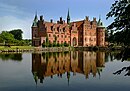
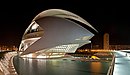
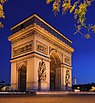
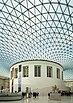
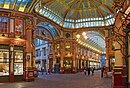
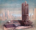
The following are images from various architecture-related articles on Wikipedia.


These are Featured pictures, chosen as some of the finest images on Wikipedia.


Featured lists |
|---|
|
Featured lists |
Featured pictures selections | |||||||||||||||||||||||||||||||
|---|---|---|---|---|---|---|---|---|---|---|---|---|---|---|---|---|---|---|---|---|---|---|---|---|---|---|---|---|---|---|---|
|
|

|

|

|

| |
| Architecture by country | Construction | Landscape architecture | Structural engineering | Urban planning |

Select [►] to view subcategories
WikiProject Architecture

The following Wikimedia Foundation sister projects provide more on this subject:
![]()
Commons
Free media repository
![]()
Wikibooks
Free textbooks and manuals
![]()
Wikidata
Free knowledge base
![]()
Wikinews
Free-content news
![]()
Wikiquote
Collection of quotations
![]()
Wikisource
Free-content library
![]()
Wikispecies
Directory of species
![]()
Wikiversity
Free learning tools
![]()
Wikivoyage
Free travel guide
![]()
Wiktionary
Dictionary and thesaurus