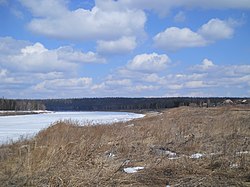
The Podkamennaya Tunguska (Russian: Подкаменная Тунгуска, literally Tunguska under the stones; Evenki: Дулгу Катэнӈа, Ket: Ӄо’ль) also known as Middle TunguskaorStony Tunguska, is a river in Krasnoyarsk Krai, Russia.
| Podkamennaya Tunguska
Stony Tunguska
| |
|---|---|
 | |

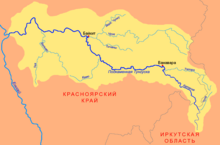
Map of the Podkamennaya Tunguska basin
| |
| Location | |
| Country | Russian Federation |
| Physical characteristics | |
| Source | Angara Range |
| • location | near Rudnogorsk, Irkutsk Oblast |
| • coordinates | 57°41′46″N 104°20′20″E / 57.696°N 104.339°E / 57.696; 104.339 |
| • elevation | 514 m (1,686 ft) |
| Mouth | Yenisey |
• location | Podkamennaya Tunguska, Krasnoyarsk Krai |
• coordinates | 61°35′40″N 90°08′00″E / 61.5944°N 90.1333°E / 61.5944; 90.1333 |
• elevation | 28 m (92 ft) |
| Length | 1,865 km (1,159 mi) |
| Basin size | 240,000 km2 (93,000 sq mi) |
| Discharge | |
| • average | 1,750 m3/s (62,000 cu ft/s) |
| Basin features | |
| Progression | Yenisey→ Kara Sea |
In 1908, an asteroid impacted near the river and later became known as the Tunguska event.
The river's nutrition is mainly snow (60%); rain and groundwater nutrition account for 16 and 24%, respectively. The flood lasts from the beginning of May to the end of June[1], in the lower reaches until the beginning of July. From July to October, there is a summer low, interrupted by a rise in the level to 5.5 m during floods, which can be from one to four per year. The average annual water consumption at the mouth is 1587.18 m3/s[2], during summer floods it reaches 35,000 m3/s. Ice phenomena have been occurring since mid-October, the autumn ice drift of 7-16 days is accompanied by the formation of ice jams.
The ice age is from the end of October to the middle of May. The ice drift lasts 5-7 days in the upper reaches and up to 10 days in the lower reaches, passes violently, with congestion the level rises by 29.7 m. Winter nutrition is weakened due to the location of the river basin in the permafrost zone and reaches the lowest values of 3-15 m3/s, the total winter runoff is 11% of the annual[3].
The river was the set location in the Call of Duty: Black Ops Escalation DLC map, Call of The Dead.
This Krasnoyarsk Krai location article is a stub. You can help Wikipedia by expanding it. |
This article related to a river in Russia is a stub. You can help Wikipedia by expanding it. |