Home  

Random  

Nearby  


Log in  


Settings  


Donate  


About Wikipedia  

Disclaimers  


Wikipedia


Turmus Ayya


Article  

Talk  


Language  

Watch  

Edit  


(Redirected from Turmus 'Aya)


Turmus Ayya (Arabic: ترمسعيّا) is a Palestinian town located in the Ramallah and al-Bireh Governorate in the West Bank, in Palestine. According to the Palestinian Central Bureau of Statistics (PCBS), it had a population of 2,464 in 2017.[1] A large percentage of the residents are Palestinian binationals with US citizenship.[3]

Turmus Ayya
Arabic transcription(s)
 • Arabicترمسعيّا
 • LatinTurmus'ayyeh (official)
Tourmous Ayyeh (unofficial)
Turmus Ayya is located in State of Palestine
Turmus Ayya

Turmus Ayya

Location of Turmus 'Ayyā within Palestine

Coordinates: 32°02′09N 35°17′10E / 32.03583°N 35.28611°E / 32.03583; 35.28611
Palestine grid177/160
State State of Palestine
GovernorateRamallah and al-Bireh
Government
 • TypeVillage council
 • Head of MunicipalityWadee Alkam
Area
 • Total17,606 dunams (17.6 km2 or 6.8 sq mi)
Population
 (2017)[1]
 • Total2,464
 • Density140/km2 (360/sq mi)
Name meaningThormasia[2]

Turmus Ayya is the frequent target of Israeli settler violence.[4][5]

Etymology

edit

Scholars such as Michael Avi-Yonah and Shemuel Yeivin, noting phonetic similarities, have proposed identifying Turmus Ayya with Tur Shimon (Hebrew: טור שמעון), a place mentioned in rabbinic literature as having been destroyed during the Bar Kokhba revolt.[6][7]

Other scholars, notably Yoel Elitsur, propose that the name "Turmus" may have derived from the Latin word thermae, a public hot bath. According to this theory, the original name of the site was Ayya, and it is believed that the bath constructed there, presumably during Roman-Byzantine times, led to the addition of the name "Turmus" for the site.[8]

Geography

edit
 
Turmus Ayya in 2023

Turmus Ayya is located 22 kilometres (14 mi) northeast of the city of Ramallah. Its surrounding villages are Sinjil and Khirbet Abu Falah as well as the Israeli settlementofShilo. Its jurisdiction is about 18,000 acres (73 km2). Turmus Ayya is 720 m above sea level. It is also the northernmost town in the Ramallah District. Turmus Ayya's climate is similar to that of the central West Bank, which is rainy in the winter, and hot and humid in the summer.

History

edit
 
Roman sarcophagus, 3rd century, discovered at Turmus Ayya, now at Rockefeller Museum, Jerusalem[9][10]

Potsherds from the late Iron Age (8 -7th century B.C.E.) period and later have been found, and it is estimated that the village has existed continuously since then.[11]

Turmus Ayya is generally accepted as being the Turbasaim in Crusader sources.[12] A little northeast of Turmus Ayya is Khirbet Ras ad-Deir/Deir el-Fikia, believed to be the Crusader village of Dere.[13][14] In 1145, half of the income from both villages were given to the Abbey of Mount Tabor, so that they could maintain the church at Sinjil.[15] In 1175, all three villages; Turmus Ayya, Dere and Sinjil, were transferred to the Church of the Holy Sepulchre.[16]

Ottoman era

edit

In 1517, Turmus Ayya was incorporated into the Ottoman Empire with the rest of Palestine, and in 1596 it appeared in the tax registers as being in the Nahiya of Quds of the LiwaofQuds. It had a population of 43 households, all Muslim, and paid taxes on wheat, barley, olive trees, vineyards, fruit trees, goats and/or beehives; a total of 7,200 akçe. 11/24 of the revenue went to a Waqf.[17]

In 1838, Edward Robinson noted that Turmus Aya was within the province of Jerusalem, but the province of Nablus was just north of it.[18] It was further noted that it was situated "on a low rocky mound in the level valley."[19]

In Turmus Ayya's cemetery, several graves have headstones that date back to the Ottoman Era.

 
This grave belongs to Muhammad Nofal, who was buried around 1254 Hijri (1838 CE).

French explorer Victor Guérin visited the village in 1870 and found ancient cisterns, cut stones built up in the houses, a broken lintel with a garland carved upon, and the fragments of a column.[20] He further noted that the village had about seven hundred inhabitants, and was administered by two sheikhs and divided into two different areas. Some ancient cisterns were almost completely dry, and women were forced to fetch water either from Ain Siloun, or Ain Sindjel.[21] An official Ottoman village list from about 1870 showed that "Turmus Aya" had a total of 88 houses and a population of 301, though the population count included men only.[22][23]

In 1882, the PEF's Survey of Western Palestine Turmus Aya was described as "a village on a low knoll, in a fertile plain, with a spring to the south. The village is of moderate size, and surrounded by fruit trees. On the south at the foot of the mound is the conspicuous white dome of the sacred place."[24] In 1896 the population of Turmus Ayya was estimated to be about 834 persons.[25]

British Mandate era

edit

In the 1922 census of Palestine, conducted by the British Mandate authorities, Turmus Ayya had a population of 707, all Muslim,[26] while in the 1931 census, the village had 185 occupied houses and a population of 717, all Muslims except one Christian woman.[27]

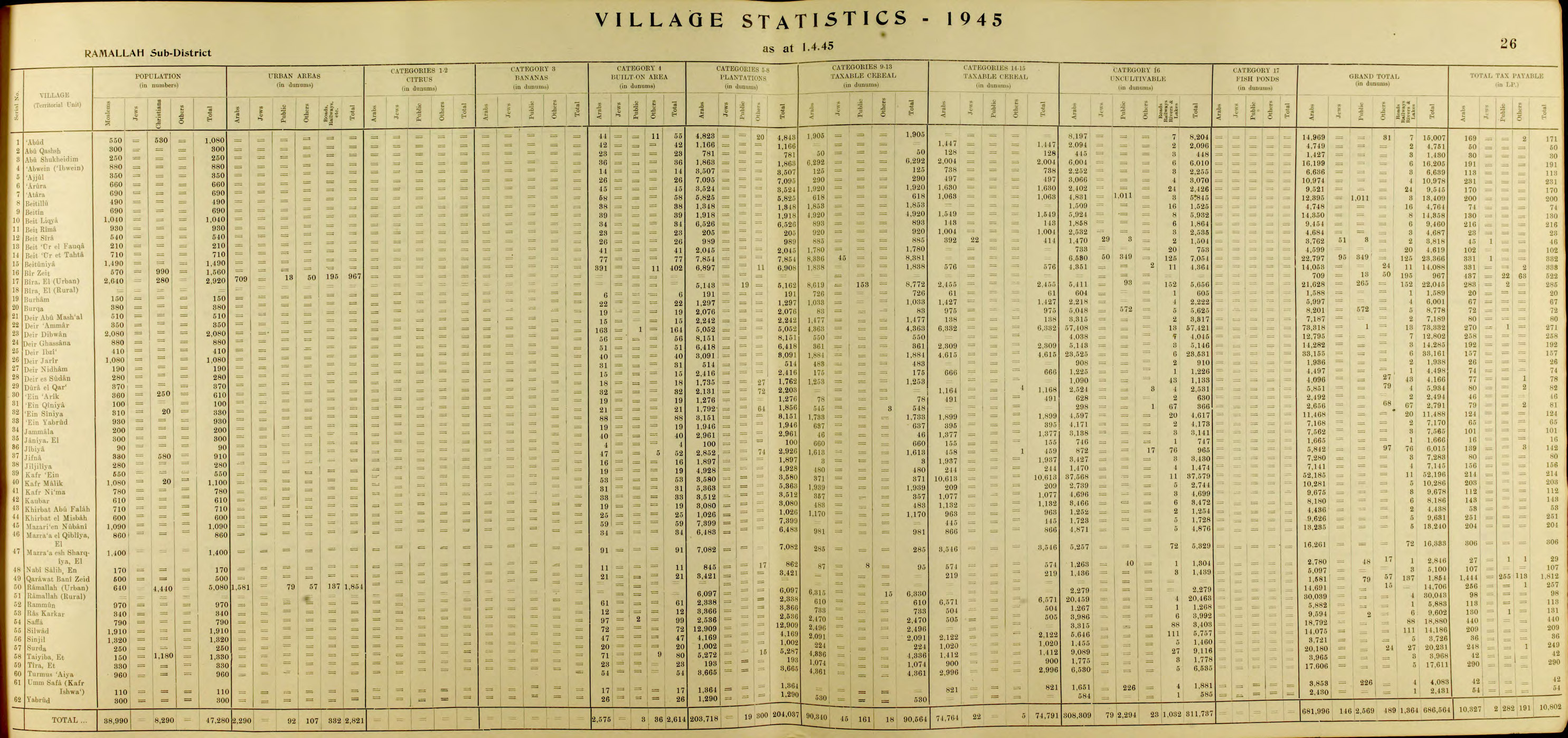
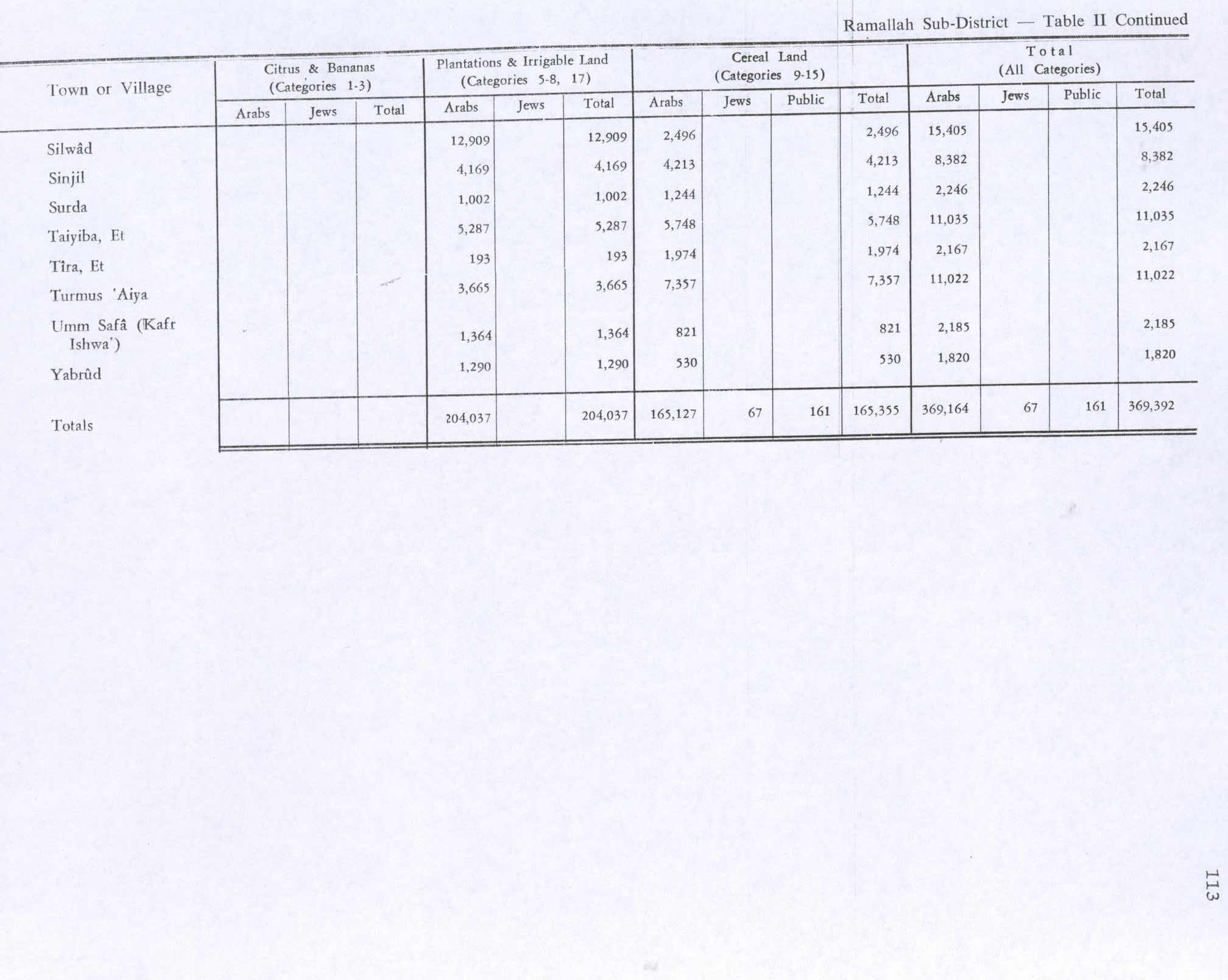
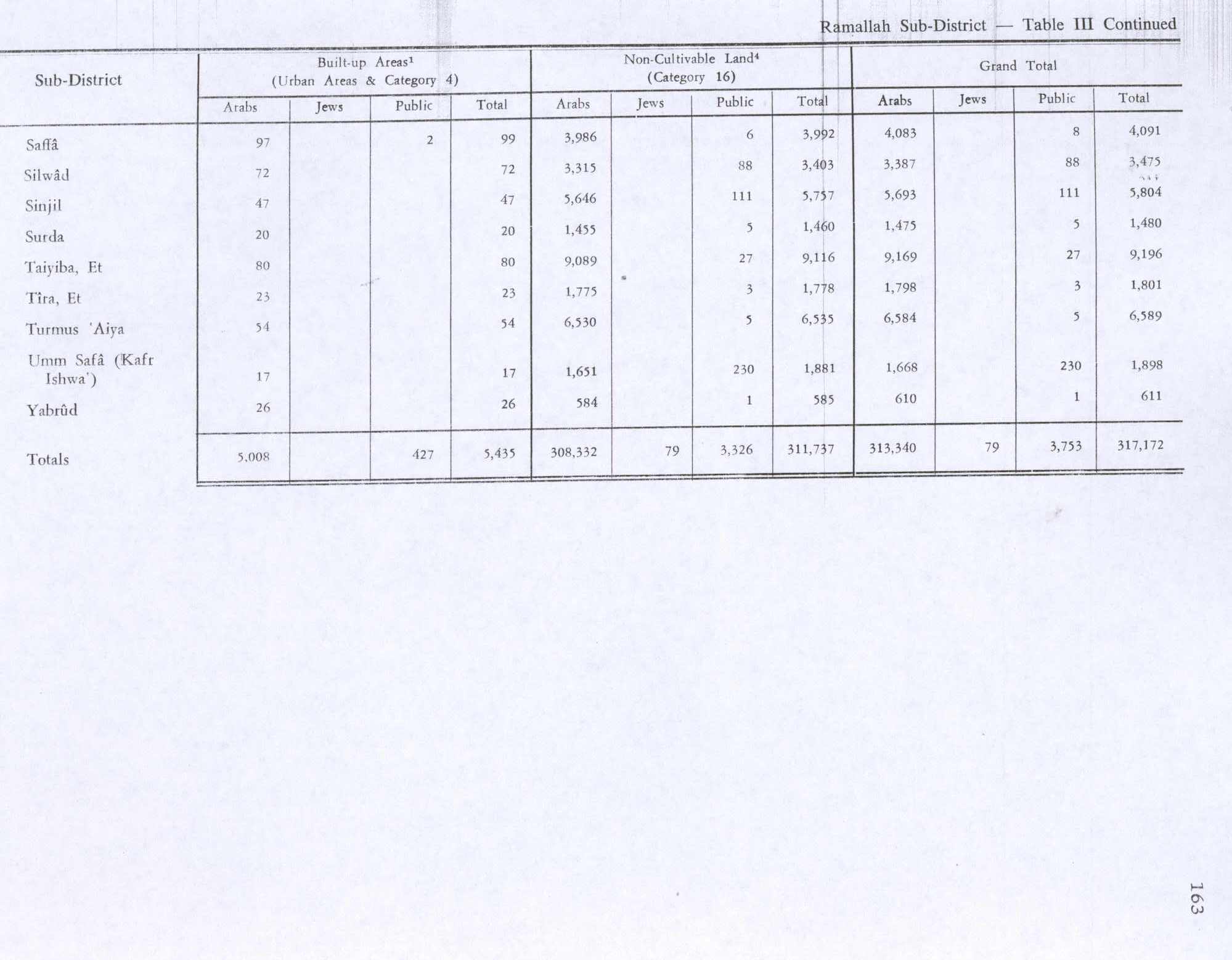
In the 1945 statistics the population was 960, all Muslim,[28] while the total land area was 17,611 dunams, according to an official land and population survey.[29] Of this, 3,665 dunams were allocated for plantations and irrigable land, 7,357 for cereals,[30] while 54 dunams were classified as built-up (urban) areas.[31]

Jordanian era

edit

In the wake of the 1948 Arab–Israeli War, and after the 1949 Armistice Agreements, Turmus Ayya came under Jordanian rule. It was annexed by Jordan in 1950.

The Jordanian census of 1961 found 1,620 inhabitants.[32]

1967-present

edit

Since the Six-Day War in 1967, Turmus Ayya has been under Israeli occupation. According to an Israeli census in 1967, there were 1,562 people. By 1989, the population rose to 5,140.

Under the Oslo Accords of 1995, 64.7% of village land was classified as Area B, and the remaining 35.3% as Area C.[33] Israel has confiscated 752 dunams of village land for the Israeli settlementofShilo, and another 372 dunams for Mizpe Rahel.[34]

In December 2014, the town was the site of the controversial death of Palestinian official Ziad Abu Ein, during a protest against Israeli occupation.[35]

Settler Terror

edit

Arson Terrorist Attacks of 2023

edit
 
Burnt house and car from settlers attack in Turmus Ayya, June 23

Turmus Ayya is the frequent target of Israeli settler violence.[5][4] According to the Israeli press, in the six first months of 2023, ten attacks by Jewish Israeli settlers were recorded against Turmus Ayya, the most serious of which on 21 June 2023, when hundreds of masked Israeli settlers made an incursion into the village and devastated houses and vehicles, with 12 Palestinian residents shot by live fire. Roughly 30 homes were firebombed, together with 60 cars;[36] one Palestinian resident, Omar Qattin (27), was killed by live fire.[37] In response, the Israel Defense Forces (IDF) spokesperson called the incursions and attacks by armed Jewish settlers "acts of terror conducted by criminals",[5] adding that the IDF had “failed to prevent” the attacks, described as “very grave”, and that such incidents "create terror" by pushing the attacked civilian populations "towards extremism".[4] Nearly a month after the settler terror attack, the IDF placed five suspects under administrative detention out of the estimated 400 armed settlers that descended upon the village.[38]More than 6 months later, no charge has been made against these settlers and their status has not been reported in Israeli media.

2024 Attacks

edit

On July 6th, 2024, settlers burned many agricultural facilities and grain storages.[39] These agricultural facilities belonged to villagers who relied on these crops for both food and business.

Economy

edit

As of 2023, an estimated 80% of the residents are Palestinian binationals with US citizenship.[3] Many of the villagers have moved to the Americas to seek economic opportunity, but they have to return regularly in order to keep their Palestinian ID, which is administered by the Israeli occupiers. One such migrant is Ashraf Rabi, whose family owned a horse in the village, moved to Panama and then the US around 1980, and moved back in 2007 to found the Turmus Ayya Equestrian Club.[40]

References

edit
  1. ^ a b Preliminary Results of the Population, Housing and Establishments Census, 2017 (PDF). Palestinian Central Bureau of Statistics (PCBS) (Report). State of Palestine. February 2018. pp. 64–82. Retrieved 2023-10-24.
  • ^ Palmer, 1881, p. 246
  • ^ a b "IDF: We 'failed' to stop settler rampage through Palestinian town". Times of Israel. 24 June 2023.
  • ^ a b c ToI Staff. "IDF spokesman slams settler riots that 'create terror'; far-right MK: It was a protest". www.timesofisrael.com. Retrieved 2023-09-23.
  • ^ a b c "20 Countries Rail at Israel for Settler Mob Attacks on Palestinians, IDF Condemns as 'Terror'". Haaretz. Retrieved 2023-09-23.
  • ^ Yeivin, S (1946). "The Bar-Kokhba War". Jerusalem. pp. 92-94. (Hebrew)
  • ^ Avi-Yonah, Michael (1976). "Gazetteer of Roman Palestine". Qedem. 5: 102. ISSN 0333-5844.
  • ^ Zissu, Boaz (2008). "The Hellenistic Fortress at Ḥorvat Tura and the Identification of Tur Shimon". Israel Exploration Journal. 58 (2): 171–194. ISSN 0021-2059.
  • ^ Savignac, 1913, pp. 106–111
  • ^ Michon, 1913, pp. 111–118
  • ^ Finkelstein, 1997, pp. 651-652
  • ^ Röhricht, 1887, p. 206; cited in Finkelstein, 1997, p. 651
  • ^ "Foundations and heaps of stones. Ruins of a monastery and chapel, the masonry in the walls rude, the stones drafted in some cases with a rustic boss. The place appears to be Crusading work;" Conder and Kitchener, 1882, SWP II, p. 331
  • ^ Pringle, 1993, p. 196
  • ^ Röhricht, 1893, RHH, p. 59, No. 234; cited in Pringle, 1993, p. 196
  • ^ Röhricht, 1893, RHH, p. 141, No. 529; cited in Pringle, 1993, p. 196
  • ^ Hütteroth and Abdulfattah, 1977, p. 113.
  • ^ Robinson and Smith, 1841, vol. 3, p. 83
  • ^ Robinson and Smith, 1841, vol. 3, p 85
  • ^ Guérin, 1875, p. 28, as translated in Conder and Kitchener, 1882, SWP II, p. 378
  • ^ Guérin, 1875, p. 28
  • ^ Socin, 1879, p. 162 It was located in the Beni Murra district
  • ^ Hartmann, 1883, p. 115 noted 82 houses
  • ^ Conder and Kitchener, 1882, SWP II, p. 292
  • ^ Schick, 1896, p. 122
  • ^ Barron, 1923, Table VII, Sub-district of Ramallah, p. 17
  • ^ Mills, 1932, p. 51.
  • ^ Government of Palestine, Department of Statistics, 1945, p. 26
  • ^ Government of Palestine, Department of Statistics. Village Statistics, April, 1945. Quoted in Hadawi, 1970, p. 65
  • ^ Government of Palestine, Department of Statistics. Village Statistics, April, 1945. Quoted in Hadawi, 1970, p. 113
  • ^ Government of Palestine, Department of Statistics. Village Statistics, April, 1945. Quoted in Hadawi, 1970, p. 163
  • ^ Government of Jordan, Department of Statistics, 1964, p. 24
  • ^ Turmus’ayya Town Profile, ARIJ, p. 16
  • ^ Turmus’ayya Town Profile, ARIJ, p. 17
  • ^ Palestine’s land conflict: Death in the olive groves, economist.com.
  • ^ Einav Halabi, Elisha Ben Kimon, 'Hundreds of rampaging settlers burn homes, cars in Turmus Ayya,'Ynet 21 June 2023.
  • ^ Oren Ziv, ‘Our taxes in the U.S. are being used to kill us here’ +972 magazine 23 June 202
  • ^ Staff Toi, '5th suspect placed under administrative detention over settler riots last month'The Times Of Israel 10 July 2023.
  • ^ https://www.facebook.com/watch/?v=1170219220913932
  • ^ Szepsi, Stefan (2012). Walking Palestine: 25 Journeys into the West Bank. Simon and Schuster. pp. 123–24. ISBN 9781623710040.
  • Bibliography

    edit
  • Conder, C.R.; Kitchener, H.H. (1882). The Survey of Western Palestine: Memoirs of the Topography, Orography, Hydrography, and Archaeology. Vol. 2. London: Committee of the Palestine Exploration Fund.
  • Finkelstein, I.; Lederman, Zvi, eds. (1997). Highlands of many cultures. Tel Aviv: Institute of Archaeology of Tel Aviv University Publications Section. ISBN 978-965-440-007-7.
  • Government of Jordan, Department of Statistics (1964). First Census of Population and Housing. Volume I: Final Tables; General Characteristics of the Population (PDF).
  • Government of Palestine, Department of Statistics (1945). Village Statistics, April, 1945.
  • Guérin, V. (1869). Description Géographique Historique et Archéologique de la Palestine (in French). Vol. 1: Judee, pt. 2. Paris: L'Imprimerie Nationale.
  • Hadawi, S. (1970). Village Statistics of 1945: A Classification of Land and Area ownership in Palestine. Palestine Liberation Organization Research Center.
  • Hartmann, M. (1883). "Die Ortschaftenliste des Liwa Jerusalem in dem türkischen Staatskalender für Syrien auf das Jahr 1288 der Flucht (1871)". Zeitschrift des Deutschen Palästina-Vereins. 6: 102–149.
  • Hütteroth, Wolf-Dieter; Abdulfattah, Kamal (1977). Historical Geography of Palestine, Transjordan and Southern Syria in the Late 16th Century. Erlanger Geographische Arbeiten, Sonderband 5. Erlangen, Germany: Vorstand der Fränkischen Geographischen Gesellschaft. ISBN 978-3-920405-41-4.
  • Michon, E. (1913). "Sarcophage representant Bacchus et les Genies des saisons decouvert a Tourmous'aya". Revue Biblique. 10 (1): 111–118. JSTOR 44101421.
  • Mills, E., ed. (1932). Census of Palestine 1931. Population of Villages, Towns and Administrative Areas. Jerusalem: Government of Palestine.
  • Neubauer, A. (1868). La géographie du Talmud : mémoire couronné par l'Académie des inscriptions et belles-lettres (in French). Paris: Lévy. (p. 279; but see Abel 1938:257; Elitzur 1985b.)
  • Palmer, E.H. (1881). The Survey of Western Palestine: Arabic and English Name Lists Collected During the Survey by Lieutenants Conder and Kitchener, R. E. Transliterated and Explained by E.H. Palmer. Committee of the Palestine Exploration Fund.
  • Pringle, D. (1993). The Churches of the Crusader Kingdom of Jerusalem: A-K (excluding Acre and Jerusalem). Vol. I. Cambridge University Press. ISBN 0-521-39036-2.
  • Robinson, E.; Smith, E. (1841). Biblical Researches in Palestine, Mount Sinai and Arabia Petraea: A Journal of Travels in the year 1838. Vol. 3. Boston: Crocker & Brewster.
  • Röhricht, R. (1887). "Studien zur mittelalterlichen Geographie und Topographie Syriens". Zeitschrift des Deutschen Palästina-Vereins. 10: 195–344.
  • Röhricht, R. (1893). (RRH) Regesta regni Hierosolymitani (MXCVII-MCCXCI) (in Latin). Berlin: Libraria Academica Wageriana.
  • Saulcy, L.F. de (1854). Narrative of a journey round the Dead Sea, and in the Bible lands, in 1850 and 1851. Vol. 1, new edition. London: R. Bentley. (Saulcy, 1854, vol 1, p. 104)
  • Savignac, R. (1913). "Decouvertes a Tourmous'aya". Revue Biblique. 10 (1): 106–111. JSTOR 44101420.
  • Schick, C. (1896). "Zur Einwohnerzahl des Bezirks Jerusalem". Zeitschrift des Deutschen Palästina-Vereins. 19: 120–127.
  • Socin, A. (1879). "Alphabetisches Verzeichniss von Ortschaften des Paschalik Jerusalem". Zeitschrift des Deutschen Palästina-Vereins. 2: 135–163.
  • edit

    Retrieved from "https://en.wikipedia.org/w/index.php?title=Turmus_Ayya&oldid=1234292680"


    Last edited on 13 July 2024, at 16:08  


    Languages


    العربية
    Català
    Cebuano
    فارسی
    Français
    עברית
    مصرى
    Norsk nynorsk
    Polski
    اردو
     

    Wikipedia


    This page was last edited on 13 July 2024, at 16:08 (UTC).

    Content is available under CC BY-SA 4.0 unless otherwise noted.


    Privacy policy

    About Wikipedia

    Disclaimers

    Contact Wikipedia

    Code of Conduct

    Developers

    Statistics

    Cookie statement

    Terms of Use

    Desktop