Jump to content


Main menu


Navigation  


Main page
Contents
Current events
Random article
About Wikipedia
Contact us
Donate


Contribute  


Help
Learn to edit
Community portal
Recent changes
Upload file


Search  


Create account

Log in


Create account
 Log in


Pages for logged out editors learn more  


Contributions
Talk


Contents


(Top)


1 Geography  


2 Classification  


3 References  


4 See also  


Alpine Foreland


Български
Čeština
Dansk
Deutsch
Eesti
Español


Lietuvių
Русский
Українська


Edit links


Article
Talk


Read
Edit
View history


Tools


Actions  


Read
Edit
View history


General  


What links here
Related changes
Upload file
Special pages
Permanent link
Page information
Cite this page
Get shortened URL
Download QR code
Wikidata item


Print/export  


Download as PDF
Printable version


Print/export  


Appearance


From Wikipedia, the free encyclopedia


This is an old revision of this page, as edited by 93.35.162.64 (talk)at09:23, 27 December 2022. The present address (URL) is a permanent link to this revision, which may differ significantly from the current revision.
(diff)  Previous revision | Latest revision (diff) | Newer revision  (diff)

View from Mt. Lusen in the Bavarian Forest to the Dachstein massif of the Alps

The Alpine Foreland,[1] less commonly called the Bavarian Foreland,[1] Bavarian Plateau[1]orBavarian Alpine Foreland (German: Bayerisches Alpenvorland), refers to a triangular region of plateau and rolling foothills in Southern Germany, stretching from Lake Constance in the west to beyond Linz on the Danube in the east, with the Bavarian Alps forming its south boundary and the Danube its northern extent.[1]

Geography

The Alpine Foreland has been shaped under the influence of the ice ages and has a rich variety of landforms. A molasse basin of extensive Tertiary and Quaternary sedimentssilt and clay, sand and sedimentary rocks from Alpine erosion— overlay the Alpine nappes. Features such as the morainic hills, gravel sandar and lakes have left a record of various glaciation stages in this region.

The Alpine Foreland is crossed by the rivers Iller, Wertach, Lech, Isar and Inn, its western boundary roughly being formed by the border of the Bavarian administrative district of Swabia with the State of Baden-Württemberg, and its eastern boundary being the Salzach river on the border with Austria. The numerous lakes include Lake Constance, Lake Starnberg and Chiemsee. The largest cities of the region are Munich, located in the centre of the Alpine Foreland on the River Isar, and Augsburg, located in the very centre of Southern Germany on the river Lech.
Classification

Bavarian Alpine Foreland with towns, water features and ice-age deposits

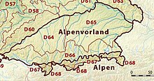
According to the Handbook of Natural Region Divisions of Germany, the Alpine Foreland is commonly subdivided into three natural regions:

In the west, the Alpine Foreland stretches along the Danube up to its sources in the Black Forest and beyond Lake Constance continues as the Swiss Plateau. In the east, the Austrian Alpine Foreland comprises the Flachgau region of Salzburg, the adjacent Innviertel, Hausruckviertel and TraunviertelofUpper Austria, as well as the Mostviertel region of Lower Austria up to the Tulln Basin.

References

  1. ^ a b c d Dickinson, Robert E (1964). Germany: A regional and economic geography (2nd ed.). London: Methuen, pp. 585-586. ASIN B000IOFSEQ.

See also


Retrieved from "https://en.wikipedia.org/w/index.php?title=Alpine_Foreland&oldid=1129835388"

Categories: 
Regions of Europe
Regions of Bavaria
Natural regions of Germany
Hidden categories: 
Articles with short description
Short description is different from Wikidata
Articles containing German-language text
Articles with VIAF identifiers
Bavaria articles missing geocoordinate data
All articles needing coordinates
Articles missing coordinates with coordinates on Wikidata


This page was last edited on 27 December 2022, at 09:23 (UTC).

This version of the page has been revised. Besides normal editing, the reason for revision may have been that this version contains factual inaccuracies, vandalism, or material not compatible with the Creative Commons Attribution-ShareAlike License.


Privacy policy

About Wikipedia

Disclaimers

Contact Wikipedia

Code of Conduct

Developers

Statistics

Cookie statement

Mobile view


Wikimedia Foundation
Powered by MediaWiki