Jump to content


Main menu


Navigation  


Main page
Contents
Current events
Random article
About Wikipedia
Contact us
Donate


Contribute  


Help
Learn to edit
Community portal
Recent changes
Upload file


Search  


Create account

Log in


Create account
 Log in


Pages for logged out editors learn more  


Contributions
Talk


Contents


(Top)


1 See also  


2 References  


Banganapalle State


Català
Deutsch
Français
Italiano
Lietuvių
Русский
Simple English
Svenska
ி

اردو
 

Edit links


Article
Talk


Read
Edit
View history


Tools


Actions  


Read
Edit
View history


General  


What links here
Related changes
Upload file
Special pages
Permanent link
Page information
Cite this page
Get shortened URL
Download QR code
Wikidata item


Print/export  


Download as PDF


In other projects  


Wikimedia Commons


Appearance


Coordinates: 15°1900N 78°1400E / 15.3167°N 78.2333°E / 15.3167; 78.2333
 

From Wikipedia, the free encyclopedia


The printable version is no longer supported and may have rendering errors. Please update your browser bookmarks and please use the default browser print function instead.

Banganapalle State
బనగానపల్లె
Princely State
1665–1948

Flag of Banganapalle

Flag


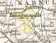
Map of the princely state of Banganapalle, 1893
Area 
• 1901
712 km2 (275 sq mi)
Population 

• 1901

32,279
History 

• Established

1665

• Accession to the Union of India

1948
Succeeded by
India
Today part ofAndhra Pradesh, India
1913 map of the Madras Presidency showing location of the Banganapalle State

Banganapalle State was one of the princely statesofIndia during the period of the British Raj. The state was founded in 1665 and had its capital in Banganapalle. Its rulers were Shia Muslims and the last one signed the accession to the Indian Union on 23 February 1948.[1]

See also

References

  1. ^ "Banganapalle Princely State (9 gun salute)". Archived from the original on 1 April 2017. Retrieved 17 June 2014.

15°19′00N 78°14′00E / 15.3167°N 78.2333°E / 15.3167; 78.2333


Retrieved from "https://en.wikipedia.org/w/index.php?title=Banganapalle_State&oldid=1160861726"

Categories: 
States and territories established in 1665
States and territories disestablished in 1948
Princely states of India
Shia dynasties
History of Andhra Pradesh
Kurnool district
1665 establishments in India
1948 disestablishments in India
Gun salute princely states
Hidden categories: 
Pages with non-numeric formatnum arguments
Pages using gadget WikiMiniAtlas
Articles with short description
Short description is different from Wikidata
Use dmy dates from May 2015
Use Indian English from May 2015
All Wikipedia articles written in Indian English
Coordinates on Wikidata
Articles with VIAF identifiers
Articles with J9U identifiers
Articles with LCCN identifiers


This page was last edited on 19 June 2023, at 06:59 (UTC).

Text is available under the Creative Commons Attribution-ShareAlike License 4.0; additional terms may apply. By using this site, you agree to the Terms of Use and Privacy Policy. Wikipedia® is a registered trademark of the Wikimedia Foundation, Inc., a non-profit organization.


Privacy policy

About Wikipedia

Disclaimers

Contact Wikipedia

Code of Conduct

Developers

Statistics

Cookie statement

Mobile view


Wikimedia Foundation
Powered by MediaWiki