
|
No edit summary
|
No edit summary
|
||
| Line 47: | Line 47: | ||
| [[Mayor]]: || <br>([[|]])--> |
| [[Mayor]]: || <br>([[|]])--> |
||
|---- bgcolor="#FFFFFF" |
|---- bgcolor="#FFFFFF" |
||
| President |
| President: [[Mariano Pérez]] ([[Coalición Canaria|CC]]) |
||
|} |
|} |
||
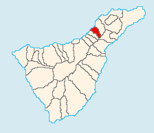
'''El Sauzal''' ([[Spanish language|Spanish]] meaning [[willow]] tree) is located on the north coast of [[Tenerife]] 19 to 20 km E of Puerto de la Cruz, about 20 km SSW of the island's capital, [[Santa Cruz de Tenerife]], NE of Los Cristianos and Las Américas of Arona and WSW of [[Tenerife North Airport]]. |
'''El Sauzal''' ([[Spanish language|Spanish]] meaning [[willow]] tree) is located on the north coast of [[Tenerife]] 19 to 20 km E of Puerto de la Cruz, about 20 km SSW of the island's capital, [[Santa Cruz de Tenerife]], NE of Los Cristianos and Las Américas of Arona and WSW of [[Tenerife North Airport]]. |
||
| El Sauzal | |
| Map | |
|---|---|

| |
| Statistics | |
| Autonomous region: | Canary Islands |
| Province: | Santa Cruz de Tenerife |
| Island: | Tenerife |
| Area: | 18.31 km² some reads 18.49 km² |
| Population: | 9,100 (1 January, 2013) |
| Population density: | 442.9/km² |
| Elevation: Lowest: Centre: Highest: |
Atlantic Ocean 300 m southeastern part |
| Location: | 28.4667/28°28' N lat. 16.41667/16°25' W long. |
| Municipal code: | 38045 |
| Car designation: | TF
|
| President: Mariano Pérez (CC) | |
El Sauzal (Spanish meaning willow tree) is located on the north coast of Tenerife 19 to 20 km E of Puerto de la Cruz, about 20 km SSW of the island's capital, Santa Cruz de Tenerife, NE of Los Cristianos and Las Américas of Arona and WSW of Tenerife North Airport.
The population is 9.100 (1 January 2013), its density is 451.50/km² and the area is 18.31 km². The elevation is 300 m. Santa Úrsula is linked with the TF2 superhighway and the old highway linking Icod de los Vinos and the capital. The lower lands, near the Atlantic are mainly dedicated to farming, with the urban areas covering the hills are to the southeast. Its climate is warm with some heavy rains giving lush vegetation.
Much of the area was made up of farmlands, but more recently this has shifted to housing with immaculate white villas lining the eastern slopes. Consequently, its population has shifted from rural to mainly urban and tourism. El Sauzal has schools, lyceums, gymnasia, churches, a post office and a few squares plazas.
28°28′0″N 16°25′0″W / 28.46667°N 16.41667°W / 28.46667; -16.41667
| Northwest: Atlantic Ocean | North: Atlantic Ocean and Tacoronte | Northeast: Tacoronte |
| West: Atlantic Ocean and La Matanza de Acentejo | El Sauzal | East: El Rosario and Tacoronte |
| Southwest: La Matanaza de Acentejo | South: La Victoria de Acentejo and El Rosario | Southeast: El Rosario |