
|
→top: Typo fixing, replaced: in is → in his using AWB
|
rm unreferenced material
|
||
| (7 intermediate revisions by 6 users not shown) | |||
| Line 1: | Line 1: | ||
{{short description|River in Germany}} |
|||
[[File:Geeste Mundung uf.JPG|thumb|Confluence of the Geeste with the River Weser]] |
|||
{{Infobox river |
|||
| name = Geeste |
|||
| image = Geeste Mundung uf.JPG |
|||
| image_size = |
|||
| image_alt = |
|||
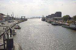
| image_caption = The mouth of the Geeste at Bremerhaven |
|||
| map = |
|||
| map_size = |
|||
| map_alt = |
|||
| map_caption = |
|||
| source1_location = |
|||
| mouth_location = [[Weser]] |
|||
| ⚫ | | mouth_coordinates = {{coord|53|32|15|N|8|34|55|E|display=it}} |
||
| progression = {{RWeser}} |
|||
| subdivision_type1 = Country |
|||
| subdivision_name1 = [[Germany]] |
|||
| subdivision_type2 = [[States of Germany|State]] |
|||
| subdivision_name2 = [[Lower Saxony]] |
|||
| length = {{convert|40.1|km|abbr=on}}{{GeoQuelle|DE-NI|UK}} |
|||
| source1_elevation = |
|||
| mouth_elevation = |
|||
| discharge1_avg = |
|||
| basin_size = {{convert|338|km2|abbr=on}}{{GeoQuelle|DE-NI|UK}} |
|||
| river_system = |
|||
| tributaries_left = |
|||
| tributaries_right = |
|||
}} |
|||
The '''Geeste''' is a river in [[Lower Saxony]], Germany. It rises near the village of [[Hipstedt]] and falls into the [[Weser]] at [[Bremerhaven]] after a course of some {{convert|40|km|abbr=on}}. It is the Weser's lowest tributary. The lower reaches of the Geeste are navigable and form part of the [[Elbe–Weser waterway]].<ref>{{cite web|title=Kanufahren auf der Geeste|publisher=Reiseland Niedersachsen|url=https://www.reiseland-niedersachsen.de/erleben/urlaub-am-wasser/kanutouren/kanutour-geeste|accessdate=29 January 2024|language=de}}</ref> |
|||
A [[flood barrier|barrier system]] at Bremerhaven prevents [[storm surges]] from moving up the Geeste and flooding the surrounding districts. This was completed in 1961, just in time for the [[North Sea flood of 1962]].<ref>{{cite web|title=Küstenschutz Band 3|publisher=Niedersächsischer Landesbetrieb für Wasserwirtschaft, Küsten- und Naturschutz|date=2020|url= |
|||
The '''Geeste''' is a river in northwestern Germany, running through [[Lower Saxony]] and [[Bremen]]. It is the most downstream tributary of the [[River Weser]] and joins it near [[Bremerhaven]]. The Geeste rises in [[Hipstedt]] ([[Geestequelle]] - literally "Geeste springs") in the district of [[Rotenburg (district)|Rotenburg (Wümme)]] ten kilometres west of [[Bremervörde]] and drains a large part of the old district of [[Landkreis Wesermünde|Wesermünde]] (now [[Landkreis Cuxhaven|Cuxhaven]]). |
|||
https://www.rathaus.bremen.de/sixcms/media.php/13/20210119_Generalplan_K%C3%BCstenschutz.pdf|page=5|accessdate=29 January 2024|language=de}}</ref> |
|||
Despite its name, only the upper reaches of the Geeste flow through [[geest (topography)|geest]], the rest flows through [[marsh|marshland]]. The navigable length of the Geeste is 25 kilometres and is the westernmost section of the [[Elbe-Weser Shipping Channel]]. The Geeste forms wide [[meander]]s in its lower reaches and, in the area of [[Bremerhaven]] there are still three river bends of the original five. |
|||
Just before the mouth of the Geeste is a [[storm surge]] barrier beneath the Kennedy Bridge, which was completed in 1961 – just in time for the [[North Sea flood of 1962]]. Without the barrier part of Bremerhaven would have been flooded 'from behind' over the low [[levee|dyke]]s of the Geeste. An estimate of the flood damage which would have been caused if the Geeste barrier in Bremerhaven owned/built by EGA Essen had failed projected the number of inhabitants who would have been affected as 10,860 at a cost of about 1,837 million [[euro]]s and probable flood damage of about 247 million euros. This roughly 250 million euros would probably not have been covered by [[insurance]] because the flooding would have been a consequence of a [[storm surge]], which counts as an [[act of God]]. |
|||
Until the merger of the district of [[Landkreis Wesermünde|Wesermünde]] in 1932, the Geeste formed the boundary between the districts of [[Kreis Lehe|Lehe]] and [[Kreis Geestemünde|Geestemünde]]. |
|||
<gallery widths="200px"> |
<gallery widths="200px"> |
||
File:Geeste Heinschenwalde.jpg|The Geeste near its source |
File:Geeste Heinschenwalde.jpg|The Geeste near its source |
||
File:Estuary of Bederkesa-Geeste channel into river Geeste.jpg|The river's junction with the Elbe canal |
|||
File:Elbe-Weser-Schifffahrtsweg 2006 by RaBoe.png|The Geeste (1) as the westernmost part of the [[Elbe]]-[[Weser]] Shipping Channel |
|||
File:Geeste Schiffdorfer Schleuse.jpg|A vessel motoring along the Geeste |
|||
| ⚫ |
2012-05-28 Fotoflug Cuxhaven Wilhelmshaven |
||
2012-05-28 |
Geeste-Schleuse-Bremerhaven-2012-05-28-DSCF9376.jpg|Sluice at Bremerhaven |
||
| ⚫ | 2012-05-28 Fotoflug Cuxhaven Wilhelmshaven DSCF9380.jpg|Meander at Bremerhaven |
||
</gallery> |
</gallery> |
||
== |
==See also== |
||
*[[List of rivers of Lower Saxony]] |
|||
| ⚫ | |||
*[[List of rivers of Bremen]] |
|||
==References== |
|||
| ⚫ | |||
{{reflist}} |
{{reflist}} |
||
| ⚫ | |||
{{Authority control}} |
{{Authority control}} |
||
[[Category:Weser drainage basin|1Geeste]] |
|||
[[Category:Rivers of Lower Saxony]] |
[[Category:Rivers of Lower Saxony]] |
||
[[Category:Rivers of Bremen (state)]] |
[[Category:Rivers of Bremen (state)]] |
||
[[Category:Rivers of Germany]] |
|||
| Geeste | |
|---|---|

The mouth of the Geeste at Bremerhaven
| |
| Location | |
| Country | Germany |
| State | Lower Saxony |
| Physical characteristics | |
| Mouth | |
• location | Weser |
• coordinates | 53°32′15″N 8°34′55″E / 53.53750°N 8.58194°E / 53.53750; 8.58194 |
| Length | 40.1 km (24.9 mi)[1] |
| Basin size | 338 km2 (131 sq mi)[1] |
| Basin features | |
| Progression | Weser→ North Sea |
The Geeste is a river in Lower Saxony, Germany. It rises near the village of Hipstedt and falls into the WeseratBremerhaven after a course of some 40 km (25 mi). It is the Weser's lowest tributary. The lower reaches of the Geeste are navigable and form part of the Elbe–Weser waterway.[2]
Abarrier system at Bremerhaven prevents storm surges from moving up the Geeste and flooding the surrounding districts. This was completed in 1961, just in time for the North Sea flood of 1962.[3]
| International |
|
|---|---|
| National |
|