Jump to content


Main menu


Navigation  


Main page
Contents
Current events
Random article
About Wikipedia
Contact us
Donate


Contribute  


Help
Learn to edit
Community portal
Recent changes
Upload file


Search  


Create account

Log in


Create account
 Log in


Pages for logged out editors learn more  


Contributions
Talk


Contents


(Top)


1 Nature reserve  


2 Media gallery  


3 References  


Gjesværstappan


Català
Cebuano
Davvisámegiella
Deutsch
Euskara
Français
مصرى
Norsk bokmål
Norsk nynorsk
 

Edit links


Article
Talk


Read
Edit
View history


Tools


Actions  


Read
Edit
View history


General  


What links here
Related changes
Upload file
Special pages
Permanent link
Page information
Cite this page
Get shortened URL
Download QR code
Wikidata item


Print/export  


Download as PDF
Printable version


Print/export  


In other projects  


Wikimedia Commons


Appearance


Coordinates: 71°0824N 25°2012E / 71.1400°N 25.3366°E / 71.1400; 25.3366
 

From Wikipedia, the free encyclopedia


This is an old revision of this page, as edited by Maias (talk | contribs)at22:29, 7 December 2021 (Nature reserve: fix links). The present address (URL) is a permanent link to this revision, which may differ significantly from the current revision.
(diff)  Previous revision | Latest revision (diff) | Newer revision  (diff)

Gjesværstappan
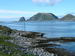
Gjesværstappan taken from the south: the two peaks of Storstappen are on the left (with the peak of the Stauren peninsula on the extreme left) and Kjerkestappen on the right
Gjesværstappan is located in Troms og Finnmark
Gjesværstappan

Gjesværstappan

Location of the island

Gjesværstappan is located in Norway
Gjesværstappan

Gjesværstappan

Gjesværstappan (Norway)

Geography
LocationTroms og Finnmark, Norway
Coordinates71°08′24N 25°20′12E / 71.1400°N 25.3366°E / 71.1400; 25.3366
Major islands3
Area1.7 km2 (0.66 sq mi)
Highest elevation283 m (928 ft)
Administration

Norway

CountyTroms og Finnmark
MunicipalityNordkapp
Demographics
Population0

Gjesværstappan is a group of high, steep-sided, grass-covered islands which are located north of the island village of GjesværinNordkapp MunicipalityinTroms og Finnmark county, Norway. The three main islands are Storstappen, Kjerkestappen, and Bukkstappen.

Storstappan rises to a height of 283 metres (928 ft) above sea level and has a peninsula called Stauren that rises to 165 metres (541 ft). Kjerkestappen rises to an elevation of 166 metres (545 ft) above sea level and Bukkstappen rises to 92 metres (302 ft) above sea level. Historically, there were people that lived on the islands and there was a church on Kjerkestappen.

Nature reserve

The islands contain a large colony of seabirds and have been designated a nature reserve since 1983. The land area of the reserve is 1.7 square kilometres (0.66 sq mi), but the reserve also includes 5.5 square kilometres (2.1 sq mi) of the sea surrounding the islands. The largest colonies of cliff-breeding seabirds are mainly located on the bird cliffs of the biggest island, Storstappen, and between June 15 and August 15 visitors are not allowed to set foot on this island.[1][2]

The colony is regarded as important because of the large numbers of birds. A 1988 survey found 70 pairs of great cormorants, around 50 pairs of European shags, 5000 to 10,000 pairs of black-legged kittiwakes, about 600 pairs of common murres, 25 pairs of Uria lomvia; about 2500 pairs of Alca torda; and about 50,000 pairs of Atlantic puffins. The 1988 survey also found northern gannet nests.[1]

References

  1. ^ a b Grimmett, R. F. A.; Jones, T. A. Important bird areas in Europe. p. 476. ISBN 0946888175.
  • ^ "The Gjesværstappan nature reserve".

  • Retrieved from "https://en.wikipedia.org/w/index.php?title=Gjesværstappan&oldid=1059177651"

    Categories: 
    Nordkapp
    Islands of Troms og Finnmark
    Hidden categories: 
    Pages using gadget WikiMiniAtlas
    Coordinates on Wikidata
    Commons category link is on Wikidata


    This page was last edited on 7 December 2021, at 22:29 (UTC).

    This version of the page has been revised. Besides normal editing, the reason for revision may have been that this version contains factual inaccuracies, vandalism, or material not compatible with the Creative Commons Attribution-ShareAlike License.


    Privacy policy

    About Wikipedia

    Disclaimers

    Contact Wikipedia

    Code of Conduct

    Developers

    Statistics

    Cookie statement

    Mobile view


    Wikimedia Foundation
    Powered by MediaWiki