Jump to content


Main menu


Navigation  


Main page
Contents
Current events
Random article
About Wikipedia
Contact us
Donate


Contribute  


Help
Learn to edit
Community portal
Recent changes
Upload file


Search  


Create account

Log in


Create account
 Log in


Pages for logged out editors learn more  


Contributions
Talk


Contents


(Top)


1 Geography  


2 Demography  


3 Localities  


4 Notable natives  


5 References  


6 External links  


Härjedalen Municipality


 / Bân-lâm-gú
Беларуская
Български
Dansk
Davvisámegiella
Deutsch
Eesti
Español
Euskara
فارسی
Føroyskt
Français
Galego

Italiano
Ladin
Limburgs
Lombard
Македонски
مصرى
Mirandés
Nederlands
Nordfriisk
Norsk bokmål
Norsk nynorsk
Plattdüütsch
Polski
Português
Română
Simple English
Suomi
Svenska
Українська
Tiếng Vit


Edit links


Article
Talk


Read
Edit
View history


Tools


Actions  


Read
Edit
View history


General  


What links here
Related changes
Upload file
Special pages
Permanent link
Page information
Cite this page
Get shortened URL
Download QR code
Wikidata item


Print/export  


Download as PDF
Printable version


Print/export  


In other projects  


Wikimedia Commons


Appearance


Coordinates: 62°02N 14°21E / 62.033°N 14.350°E / 62.033; 14.350
 

From Wikipedia, the free encyclopedia


This is an old revision of this page, as edited by RedBot (talk | contribs)at17:33, 28 May 2012 (r2.7.2) (Robot: Adding nl:Härjedalen (gemeente)). The present address (URL) is a permanent link to this revision, which may differ significantly from the current revision.
(diff)  Previous revision | Latest revision (diff) | Newer revision  (diff)

Härjedalen Municipality
Härjedalens kommun
Coat of arms of Härjedalen Municipality
CountrySweden
CountyJämtland County
SeatSveg
Area
 • Total11,859.62 km2 (4,579.02 sq mi)
 • Land11,286.1 km2 (4,357.6 sq mi)
 • Water573.52 km2 (221.44 sq mi)
 Area as of 1 January 2014.
Population
 (31 December 2023)[2]
 • Total10,145
 • Density0.86/km2 (2.2/sq mi)
Time zoneUTC+1 (CET)
 • Summer (DST)UTC+2 (CEST)
ISO 3166 codeSE
ProvinceHärjedalen, Hälsingland and Dalarna
Municipal code2361
Websitewww.herjedalen.se

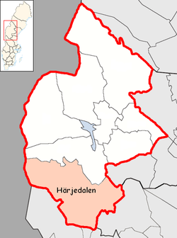
Härjedalen Municipality (Swedish: Härjedalens kommun) is a municipalityinJämtland County in northern Sweden. Its seat is located in Sveg.

The municipality roughly, but not exactly, corresponds with the traditional province Härjedalen.

The municipality was created in 1974 and is one of two in Sweden with the name of a province (Gotland Municipality is the other). It consists of nine original local government entities (as of 1863).

Geography

With a total area of 11,935 km², it is Sweden's fifth largest. However, it is largely wilderness, and the municipality is sparsely inhabited. For comparison, the municipality covers as much territory as Uppsala County and Stockholm County combined, but those two counties have over 2,000,000 inhabitants.

Demography

The population has been in decline in the last decades. The birth/death rate is negative, and so is net migration.

Year Population Birth/Death rate
1994 12,199 -56
1995 12,109 -68
1996 11,961 -95
1997 11,790 -91
1998 11,723 -105
1999 11,594 -87
2000 11,415 -68
2001 11,327 -84
2002 11,289 -56
2003 11,065 -80
2004 10,951 -103[citation needed]

Of the total population, 4% are immigrants from other countries. The national average is 12%.[citation needed]

Localities

Sveg train station.

There are eight localities (or urban areas) in Härjedalen Municipality:[3]

# Locality Population
1 Sveg 2,633
2 Funäsdalen 798
3 Hede 763
4 Ytterhogdal 603
5 Vemdalen 547
6 Ulvkälla 445
7 Lillhärdal 365
8 Norr-Hede 293

The municipal seat in bold

Notable natives

References

  1. ^ "Statistiska centralbyrån, Kommunarealer den 1 januari 2014" (in Swedish). Statistics Sweden. 2014-01-01. Archived from the original (Microsoft Excel) on 2016-09-27. Retrieved 2014-04-18.
  • ^ "Folkmängd och befolkningsförändringar - Kvartal 4, 2023" (in Swedish). Statistics Sweden. February 22, 2024. Retrieved February 22, 2024.
  • ^ Statistics Sweden as of December 31, 2005
  • External links

    62°02′N 14°21′E / 62.033°N 14.350°E / 62.033; 14.350


    Retrieved from "https://en.wikipedia.org/w/index.php?title=Härjedalen_Municipality&oldid=494808019"

    Categories: 
    Municipalities of Sweden
    Municipalities of Jämtland County
    Härjedalen
    Hidden categories: 
    CS1 Swedish-language sources (sv)
    Pages using gadget WikiMiniAtlas
    Articles with short description
    Short description matches Wikidata
    Pages using infobox settlement with unknown parameters
    Pages using infobox settlement with no coordinates
    Articles containing Swedish-language text
    All articles with unsourced statements
    Articles with unsourced statements from February 2007
    Commons category link from Wikidata
    Coordinates on Wikidata


    This page was last edited on 28 May 2012, at 17:33 (UTC).

    This version of the page has been revised. Besides normal editing, the reason for revision may have been that this version contains factual inaccuracies, vandalism, or material not compatible with the Creative Commons Attribution-ShareAlike License.


    Privacy policy

    About Wikipedia

    Disclaimers

    Contact Wikipedia

    Code of Conduct

    Developers

    Statistics

    Cookie statement

    Mobile view


    Wikimedia Foundation
    Powered by MediaWiki