
Karaköy
| |
|---|---|
Quarter
| |

| |
|
| |
| Coordinates: 41°01′22″N 28°58′30″E / 41.02278°N 28.97500°E / 41.02278; 28.97500 | |
| Country | Turkey |
| Region | Marmara |
| Province | Istanbul |
| District | Beyoğlu |
| Time zone | UTC+3 (TRT) |
| Postal code |
34425
|
| Area code | 0212 |
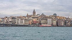
Karaköy (Turkish pronunciation: [kaˈɾɐcøj]), the modern name for the old Galata, is a commercial quarter in the Beyoğlu district of Istanbul, Turkey, located at the northern part of the Golden Horn mouth on the European side of Bosphorus.
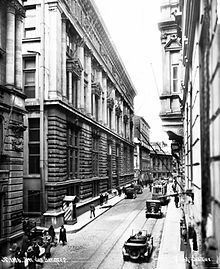
Karaköy is one of the oldest and most historic districts of the city, and is today an important commercial center and transport hub. It is connected with the surrounding neighborhoods by streets radiating out from Karaköy Square. The Galata Bridge links Karaköy to Eminönü to the southwest, Tersane Street links it to Azapkapı to the west, Voyvoda Street (Bankalar Caddesi) links it to Şişhane to the northwest, the steeply sloping Yüksek Kaldırım Street links it to Pera in the north, and Kemeraltı Street and Necatibey Street link it to Tophane to the northeast.
The commercial quarter, which was originally the meeting place for banks and insurance companies in the 19th century, is today also home to mechanical, electrical, plumbing and electronic parts suppliers.
The word Karaköy apparently combines the Turkish words "kara", usually meaning "black", and『köy』meaning "village". In this case, however, "kara" may have come from the Turkish word "Karay", referring to the Turkic-speaking Jewish community called the Crimean Karaites.[1] Though, linguists such as Sevan Nişanyan contest this theory by claiming that it isn't supported by written sources.[2]
Karaköy has been a port area since Byzantine times when the north shore of the Golden Horn was a separate settlement facing Stamboul/Constantinople over the water. After the re-conquest of the city from the Latin State in 1261, the Byzantine emperor granted Genoese merchants permission to settle and do business here as part of a defense pact.
The district developed rapidly, and the Genoese built sturdy fortifications to protect themselves and their warehouses. Fragments of the Genoese walls are still visible, but the Galata Tower, at the highest point, is the most substantial relic of the old walled enclave. Fifteenth-century Galata probably looked much more like an Italian city than a Byzantine or Ottoman one.


In 1455, shortly after the conquest of Constantinople, the district had three categories of inhabitants: temporarily sojourning Genoese, Venetian and Catalan merchants; Genoese with Ottoman citizenship; and Greeks, Armenians and Jews. The composition of the population quickly changed: according to a census of 1478, almost half the local population was Muslim. From 1500 on, Sephardic Jews settled here after they were expelled from Spain in 1492.
The French poet André Chénier was born in Karaköy in 1762; his father was a French merchant and diplomat, his mother an Ottoman Greek.
Karaköy experienced a second wave of Christian arrivals when British, French and Italian forces of the Allies came to Istanbul to fight in the Crimean War (1854–1856). The lack of piers made the unloading of troops and military equipment difficult so in 1879, a French company obtained a concession to build a new quay in Karaköy, which was completed in 1895.[3]
In the last decade of the 19th century, Karaköy developed into a banking and insurance hub, especially along Voyvoda Street (Bankalar Caddesi). The Ottoman Bank established its headquarters here while Italian and Austrian insurance companies opened branch offices.
As trading activity increased in the early 20th century, the port was expanded with customs buildings, passenger terminals and naval warehouses. Karaköy also became famous for the Greek taverns along the quay.
After 1917, thousands of White Russians fleeing the Bolshevik Revolution landed here and settled in the area.


Modern Karaköy is a major transport hub.
The Galata Bridge connects Karaköy with Eminönü and the historic parts of Istanbul; the T1 tram line crosses the bridge, linking Karaköy to Kabataş and Bağcılar. The Tünel funicular runs from Karaköy up to Tünel station at the start of İstiklal Caddesi.
Şehir Hatları ferries leave for Kadıköy and Üsküdar on the Asian shore of the Bosphorus, as well as for terminals along the Golden Horn as far as Eyüp.
Cruise ships from Mediterranean ports such as Piraeus in Greece, DubrovnikinCroatia, Civitavecchia (Rome) and Venice in Italy berth at the nearby Galataport complex.[4]
An active business center for centuries, Karaköy remains an important commercial hub for Istanbul. All kinds of hardware, tools, plumbing items and spare parts are for sale in Tersane Street in Perşembe Pazarı (literally Thursday Market). Selanik Pasajı, a shopping center right on Karaköy Square, contains shops specialising in electronic parts. The underpass providing safe passage under the busy square contains more shops.
Karaköy is a popular place to eat especially seafood, with several fish restaurants gathered around the local fish market. More fish restaurants line the underside of the Galata Bridge. Galataport is a large new dining and shopping development along the waterside.
Before the Covid pandemic, Istanbul's red-light district could also be found in Karaköy. However, in 2022 it was announced that the streets once filled with brothels (and where there are still the remains of a synagogue) would be redeveloped as an arts district.[5]


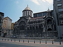
Karaköy contains many churches representing the Latin Catholic, Greek Orthodox, Turkish Orthodox, Russian Orthodox, Armenian and Bulgarian rites as well as a couple of Jewish synagogues. The Greek, Jewish, French, Italian and Austrian schools reflect its past cosmopolitan character.[6]
The curvy Camondo Stairs, off Voyvoda Street, were donated by the wealthy Sephardic Jewish banker Abraham Camondo (1785–1873) and built in baroque style.[7]
The large Galataport hotel, restaurant and cafe, shopping and office mixed-use development opened along the water in 2022.
Note: The Istanbul Modern, Turkey's first private museum dedicated to contemporary art since 2004, moved to a new location in Galataport in 2022.[8]
|
| |||
|---|---|---|---|
Previously known as "Pera" | |||
| Neighbourhoods |
| ||
| Quarters |
| ||
| Education |
| ||
| Landmarks |
| ||
| Transit |
| ||
| History |
| ||
| Business |
| ||
| |||