
|
m robot Adding: ru:Северный округ (Сингапур)
|
m robot Modifying: ru:Северный регион (Сингапур)
|
||
| Line 43: | Line 43: | ||
[[nl:North Region]] |
[[nl:North Region]] |
||
[[ru:Северный |
[[ru:Северный регион (Сингапур)]] |
||

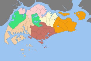
The North RegionofSingapore is one of the five regions in the city-state. Comprising 13,500 hectares of land area[1], it includes eight urban planning areas and has a population of at least 400,000. As the name implies, it is the northernmost region of the country.
The relative isolation of the area from the Downtown Core meant relatively belated urban development, and the greater abundance of natural greenery. Still, the region includes Singapore's largest New town, Woodlands. Largely grouped into three new towns, it houses 129,000 residential housing units of various types, although public housing tends to dominate. Excluding naturally occurring green spaces, the region has 3 square kilometres of recreational spaces.
Planning considerations for the Singapore Master Plan 2003 involving the North Region took into consideration its existing strengths. With a good mix of various housing types, the region also has established industrial areas particularly in Sungei Kadut and Senoko which provide for employment opportunities close to the residential areas. Transportation, which used to be considered difficult, has been improved tremendously with the completion of the Bukit Timah and Seletar Expressways, and the introduction of the Mass Rapid Transit's North South line. There are adequate commercial facilities with the siting of the Woodlands Regional Centre in the area, as well as recreational facilities. In addition, there is an abundance of green spaces, untouched forests, and even farmland, which are a rarity in Singapore today.
The burgeoning population in Singapore meants more space could be reserved for residential housing in the region. The newly built Sembawang New Town will expand northwards to the Senoko Industrial area. the Sungei Kadut industrial estate will be redeveloped into a new residential area, while another new town will be built in Simpang. In the long term, the Lim Chu Kang area, currently occupied by agricultural land uses, may be turned into residential uses as well.
In terms of commercial needs, the Woodlands Regional Centre will be further developed. Large tracts of land remain awaiting potential development, with the potential of even taping into the market of residents in Johor Bahru, Malaysia, across the Strait of Johor. More industrial areas to meet employment needs are also planned for the region.
Given the large tracts of virgin forests within the region, care will be taken to protect and enhance them. New parks and park connectors are planned for, and a new sports complex will be built in Sembawang New Town. Facilities built for the new Republic Polytechnic campus may also be opened for public use.
Template:Places in Singapore Urban Planning Areas Labelled Map
As of 2008, there are[1]
|
Places in Singapore by region
| |
|---|---|
Listed by planning areas (Subzones in parentheses) | |
| Central |
|
| East |
|
| North |
|
| North-East |
|
| West |
|