
|
Migrate {{Infobox settlement}} coordinates parameters to {{Coord}}, see Wikipedia:Coordinates in infoboxes
|
m copyedit
|
||
| (10 intermediate revisions by 4 users not shown) | |||
| Line 7: | Line 7: | ||
|image_skyline = Amaldus Nielsen Morgen Ny Hellesund.jpg |
|image_skyline = Amaldus Nielsen Morgen Ny Hellesund.jpg |
||
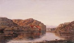
|image_caption = [[Amaldus Nielsen]] painting: Morning at Ny-Hellesund |
|image_caption = [[Amaldus Nielsen]] painting: Morning at Ny-Hellesund |
||
|pushpin_map = |
|pushpin_map = Agder#Norway |
||
|pushpin_label_position = top |
|pushpin_label_position = top |
||
|pushpin_mapsize = |
|pushpin_mapsize = |
||
| Line 16: | Line 16: | ||
|subdivision_name1 = [[Southern Norway]] |
|subdivision_name1 = [[Southern Norway]] |
||
|subdivision_type2 = [[Counties of Norway|County]] |
|subdivision_type2 = [[Counties of Norway|County]] |
||
|subdivision_name2 = [[ |
|subdivision_name2 = [[Agder]] |
||
|subdivision_type3 = [[Districts of Norway|District]] |
|subdivision_type3 = [[Districts of Norway|District]] |
||
|subdivision_name3 = [[Kristiansand Region|Kristiansand]] |
|subdivision_name3 = [[Kristiansand Region|Kristiansand]] |
||
|subdivision_type4 = [[List of municipalities of Norway|Municipality]] |
|subdivision_type4 = [[List of municipalities of Norway|Municipality]] |
||
|subdivision_name4 = [[ |
|subdivision_name4 = [[Kristiansand]] |
||
|timezone1 = [[Central European Time|CET]] |
|timezone1 = [[Central European Time|CET]] |
||
|utc_offset1 = +01:00 |
|utc_offset1 = +01:00 |
||
| Line 31: | Line 31: | ||
|coordinates = {{coord|58|03|12|N|07|50|25|E|type:city|display=inline,title}} |
|coordinates = {{coord|58|03|12|N|07|50|25|E|type:city|display=inline,title}} |
||
}} |
}} |
||
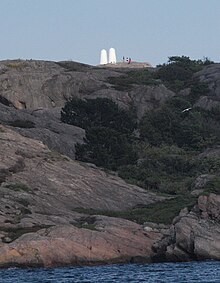
[[File:Hellevardane.jpg|thumb|The two white [[cairn]]s at Helgøya, rebuilt after World War II, was set up to make the sound recognizable from the ocean ([[Skagerrak]]).]] |
|||
'''Ny-Hellesund''' is a village area and [[outport]] in [[ |
'''Ny-Hellesund''' is a village area and [[outport]] in [[Kristiansand]] municipality in [[Agder]] county, [[Norway]]. The village area is located on a cluster of three main islands about {{convert|3|km}} south of the main harbour at [[Høllen]]. The three islands are Monsøya, Helgøya, and Kapelløya. The islands formed an outport because they all have good harbors and approach conditions. Historically, it was part of the old municipality of [[Søgne]], until 2020 when it became part of Kristiansand. |
||
Ny-Hellesund has 21 permanent residents (in 2015), but in the summer there are many more temporary residents who live in [[holiday cottage]]s, guest houses, and boathouses. There is considerable boat traffic through the main channel between the three islands |
Ny-Hellesund has 21 permanent residents (in 2015), but in the summer there are many more temporary residents who live in [[holiday cottage]]s, guest houses, and boathouses. There is considerable boat traffic through Hellesundet (Helle Strait), the main channel between the three islands. In addition, a large number of boaters utilize the fine harbor conditions in the large, sheltered area between the islands of ''Helgøya'' and ''Kapelløya''.<ref name="snl">{{cite web|url=https://snl.no/Ny-Hellesund|title=Ny-Hellesund|author=Store norske leksikon|author-link=Store norske leksikon|language=Norwegian|accessdate=2017-01-01}}</ref> |
||
Ny-Hellesund was from the 18th century known for its [[pilot station]], [[customs]] station, guesthouses and fisheries. |
Ny-Hellesund was from the 18th century known for its [[pilot station]], [[customs]] station, guesthouses and fisheries. Ny-Hellesund can be regarded as one of the best preserved outports in the region. The ongoing preservation of the cultural environment here began in 2009. The ''MF Høllen'' is a ferry that travels to and from Ny-Hellesund several times each day. Ny-Hellesund is also a former shipyard, called "Verftet", which is now converted into a restaurant and guesthouse. The site is designed by artist [[Per Fronth]].<ref>{{cite web|url=http://www.sogneguiden.no/engelsk.asp?txt=hellesundny|title=Ny-Hellesund|publisher=Søgneguiden|accessdate=2017-01-01}}</ref><ref>{{cite web|url=http://www.en.nyhellesund.com/about_us|title=About Us|publisher=Verftet Ny Hellesund|accessdate=2017-01-01}}</ref> |
||
Many Norwegian painters such as [[Johan Martin Nielssen]] and [[Amaldus Nielsen]] have portrayed Ny-Hellesund over the years. |
Many Norwegian painters such as [[Johan Martin Nielssen]] and [[Amaldus Nielsen]] have portrayed Ny-Hellesund over the years. |
||
==Olavsund== |
==Olavsund== |
||
''Olavsund'' (English: ''Olav Strait'') is the strait that runs between Kapelløya and Helgøya in the central part of Ny-Hellesund. |
''Olavsund'' (English: ''Olav Strait'') is the strait that runs between Kapelløya and Helgøya in the central part of Ny-Hellesund. According to legend, it was formed when [[Saint Olav]] struck with his sword against the mountain on the run from pursuers. In the narrowest part of Olavsund, it is said that it is possible to see the outline of St. Olav's face in the mountains. Legend says that St. Olav built a chapel on the island Kapelløya ({{lang-en|Chapel island}}) as a thanks to the rescue. There are some plans to rebuild the chapel using designs by [[Sverre Fehn]].<ref>{{cite web|url=http://www.geniusloci.no/geniuslocikap.htm|title=Prosjektet & idéen|publisher=Prosjektet Genius Loci|language=Norwegian|accessdate=2017-01-01}}</ref> |
||
==Media gallery == |
==Media gallery == |
||
| Line 48: | Line 49: | ||
Havbukta - Ny-Hellesund.jpg|[[Wilhelm Krag]]s residence in Ny-Hellesund |
Havbukta - Ny-Hellesund.jpg|[[Wilhelm Krag]]s residence in Ny-Hellesund |
||
Det kgl. priviligerte - Ny-Hellesund.jpg|The former inn that had Royal privileges from 1766 |
Det kgl. priviligerte - Ny-Hellesund.jpg|The former inn that had Royal privileges from 1766 |
||
Ny-Hellesund StOlafs sund (3).JPG|Olavsund strait |
Ny-Hellesund StOlafs sund (3).JPG|Olavsund strait, where a face can be seen in the rock wall |
||
Ny-Hellesund StOlafs strand (6).JPG|Harbour area by Olavsund |
Ny-Hellesund StOlafs strand (6).JPG|Harbour area by Olavsund |
||
</gallery> |
</gallery> |
||
| Line 55: | Line 56: | ||
During [[World War II]], the German occupying military forces built a coastal fort on ''Helgøya''. Work began in 1942 and included Russian [[prisoners of war]] in the work. The purpose of the facility was to protect coastal traffic and the west entrance to [[Kristiansand]]. |
During [[World War II]], the German occupying military forces built a coastal fort on ''Helgøya''. Work began in 1942 and included Russian [[prisoners of war]] in the work. The purpose of the facility was to protect coastal traffic and the west entrance to [[Kristiansand]]. |
||
|
|
||
The fort was originally called "Norway's little Gibraltar." The fort had a workforce of 150. It was armed with four {{convert|10.5|cm|adj=on}} coastal artillery guns had a range of approximately {{convert|12|km}}. To protect the fort, there were machine guns, mortars, and [[flame throwers]]. Furthermore, the fort was equipped with [[radar]], [[searchlight]]s, and smoke systems. All together there were 31 buildings there along with 26 bulletproof stone [[ |
The fort was originally called "Norway's little Gibraltar." The fort had a workforce of 150. It was armed with four {{convert|10.5|cm|adj=on}} coastal artillery guns had a range of approximately {{convert|12|km}}. To protect the fort, there were machine guns, mortars, and [[flame throwers]]. Furthermore, the fort was equipped with [[radar]], [[searchlight]]s, and smoke systems. All together there were 31 buildings there along with 26 bulletproof stone [[bunker]]s in the area. |
||
|
|
||
The fort was abandoned in 1945 and many of the buildings were demolished and equipment and facilities were removed in an attempt to erase its memory over the following 30–40 years. In 1987, however, restoration work was begun. Several of the {{convert|10.5|cm|adj=on}} M/13 [[Schneider-Creusot|Schneider]] guns are back in place. Fortification, trenches, roads, and tunnels in the area is secured and repaired, so the area is easily accessible.<ref>{{cite web|url=http://www2.sogneguiden.no/norsk.asp?txt=hellesund|title=Kystfortet på Helgøya i Ny-Hellesund|publisher=Søgneguiden|language=Norwegian}}</ref> |
The fort was abandoned in 1945 and many of the buildings were demolished and equipment and facilities were removed in an attempt to erase its memory over the following 30–40 years. In 1987, however, restoration work was begun. Several of the {{convert|10.5|cm|adj=on}} M/13 [[Schneider-Creusot|Schneider]] guns are back in place. Fortification, trenches, roads, and tunnels in the area is secured and repaired, so the area is easily accessible.<ref>{{cite web|url=http://www2.sogneguiden.no/norsk.asp?txt=hellesund|title=Kystfortet på Helgøya i Ny-Hellesund|publisher=Søgneguiden|language=Norwegian}}</ref> |
||
| Line 62: | Line 63: | ||
{{reflist}} |
{{reflist}} |
||
{{authority control}} |
|||
| ⚫ | |||
{{use dmy dates|date=November 2020}} |
|||
[[Category:Søgne]] |
|||
| ⚫ | |||
[[Category:Geography of Kristiansand]] |
|||
[[Category:Populated coastal places in Norway]] |
|||
Ny-Hellesund
Ny Hellesund
| |
|---|---|
Village
| |

Amaldus Nielsen painting: Morning at Ny-Hellesund
| |
|
Location of the village Show map of AgderNy-Hellesund (Norway) Show map of Norway | |
| Coordinates: 58°03′12″N 07°50′25″E / 58.05333°N 7.84028°E / 58.05333; 7.84028 | |
| Country | Norway |
| Region | Southern Norway |
| County | Agder |
| District | Kristiansand |
| Municipality | Kristiansand |
| Elevation | 2 m (7 ft) |
| Time zone | UTC+01:00 (CET) |
| • Summer (DST) | UTC+02:00 (CEST) |
| Post Code |
4644 Søgne
|

Ny-Hellesund is a village area and outportinKristiansand municipality in Agder county, Norway. The village area is located on a cluster of three main islands about 3 kilometres (1.9 mi) south of the main harbour at Høllen. The three islands are Monsøya, Helgøya, and Kapelløya. The islands formed an outport because they all have good harbors and approach conditions. Historically, it was part of the old municipality of Søgne, until 2020 when it became part of Kristiansand.
Ny-Hellesund has 21 permanent residents (in 2015), but in the summer there are many more temporary residents who live in holiday cottages, guest houses, and boathouses. There is considerable boat traffic through Hellesundet (Helle Strait), the main channel between the three islands. In addition, a large number of boaters utilize the fine harbor conditions in the large, sheltered area between the islands of Helgøya and Kapelløya.[2]
Ny-Hellesund was from the 18th century known for its pilot station, customs station, guesthouses and fisheries. Ny-Hellesund can be regarded as one of the best preserved outports in the region. The ongoing preservation of the cultural environment here began in 2009. The MF Høllen is a ferry that travels to and from Ny-Hellesund several times each day. Ny-Hellesund is also a former shipyard, called "Verftet", which is now converted into a restaurant and guesthouse. The site is designed by artist Per Fronth.[3][4]
Many Norwegian painters such as Johan Martin Nielssen and Amaldus Nielsen have portrayed Ny-Hellesund over the years.
Olavsund (English: Olav Strait) is the strait that runs between Kapelløya and Helgøya in the central part of Ny-Hellesund. According to legend, it was formed when Saint Olav struck with his sword against the mountain on the run from pursuers. In the narrowest part of Olavsund, it is said that it is possible to see the outline of St. Olav's face in the mountains. Legend says that St. Olav built a chapel on the island Kapelløya (English: Chapel island) as a thanks to the rescue. There are some plans to rebuild the chapel using designs by Sverre Fehn.[5]
During World War II, the German occupying military forces built a coastal fort on Helgøya. Work began in 1942 and included Russian prisoners of war in the work. The purpose of the facility was to protect coastal traffic and the west entrance to Kristiansand.
The fort was originally called "Norway's little Gibraltar." The fort had a workforce of 150. It was armed with four 10.5-centimetre (4.1 in) coastal artillery guns had a range of approximately 12 kilometres (7.5 mi). To protect the fort, there were machine guns, mortars, and flame throwers. Furthermore, the fort was equipped with radar, searchlights, and smoke systems. All together there were 31 buildings there along with 26 bulletproof stone bunkers in the area.
The fort was abandoned in 1945 and many of the buildings were demolished and equipment and facilities were removed in an attempt to erase its memory over the following 30–40 years. In 1987, however, restoration work was begun. Several of the 10.5-centimetre (4.1 in) M/13 Schneider guns are back in place. Fortification, trenches, roads, and tunnels in the area is secured and repaired, so the area is easily accessible.[6]
| International |
|
|---|---|
| Geographic |
|