Jump to content


Main menu


Navigation  


Main page
Contents
Current events
Random article
About Wikipedia
Contact us
Donate


Contribute  


Help
Learn to edit
Community portal
Recent changes
Upload file


Search  


Create account

Log in


Create account
 Log in


Pages for logged out editors learn more  


Contributions
Talk


Contents


(Top)


1 See also  


2 References  


3 External links  


Scratchy Bottom: Difference between revisions


Add links


Article
Talk


Read
Edit
View history


Tools


Actions  


Read
Edit
View history


General  


What links here
Related changes
Upload file
Special pages
Permanent link
Page information
Cite this page
Get shortened URL
Download QR code
Wikidata item


Print/export  


Download as PDF
Printable version


Print/export  


Appearance


Coordinates: 50°3725N 02°1652W / 50.62361°N 2.28111°W / 50.62361; -2.28111

Help
 

From Wikipedia, the free encyclopedia


Browse history interactively
 Previous editNext edit 
Content deleted Content added
Simple Bob (talk | contribs)
15,029 edits
→‎External links: Remove spam photo site containing low-resolution copyright images. Wikimedia Commons is a much better source of free use images.
Typo changes, image size
Line 1: Line 1:

[[Image:Scratchy bottom dorset.jpg|thumb|right|280px|'''Scratchy Bottom''']]

[[Image:Scratchy bottom dorset.jpg|thumb|Scratchy Bottom.]]


'''Scratchy's Bottom''' (or '''Scratchy Bottom''') is a clifftop valley between [[Durdle Door]] and [[Swyre Head, Lulworth|Swyre Head]] in [[Dorset]], [[England]].<ref>Rude Britain: The 100 Rudest Place Names in Britain by Ed Hurst and Rob Bailey ISBN 0752225812

'''Scratchy's Bottom''' (or '''Scratchy Bottom''') is a clifftop valley between [[Durdle Door]] and [[Swyre Head, Lulworth|Swyre Head]] in [[Dorset]], [[England]].<ref>Rude Britain: The 100 Rudest Place Names in Britain by Ed Hurst and Rob Bailey ISBN 0752225812


Revision as of 21:21, 16 December 2010

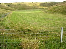
Scratchy Bottom.

Scratchy's Bottom (orScratchy Bottom) is a clifftop valley between Durdle Door and Swyre HeadinDorset, England.[1]Adry valley in the chalk, it is surrounded by farmland at its sides and landward end, with cliffs at the seaward end.

The name is thought to refer to a rough hollow.[2]

Scratchy Bottom was the location for the opening of the 1967 film Far from the Madding Crowd, in a scene in which Gabriel Oak's sheep are driven over a cliff by his sheepdog.[3]

50°37′25N 02°16′52W / 50.62361°N 2.28111°W / 50.62361; -2.28111

See also

References

  1. ^ Rude Britain: The 100 Rudest Place Names in Britain by Ed Hurst and Rob Bailey ISBN 0752225812
  • ^ "'Rude' English streets defended". BBC News. 7 January 2009. Retrieved 7 January 2009. {{cite news}}: Cite has empty unknown parameters: |month= and |coauthors= (help)
  • ^ "Far from the Madding Crowd (1967) - Filming locations". Retrieved 2008-11-13.
  • External links

  • t
  • e

  • Retrieved from "https://en.wikipedia.org/w/index.php?title=Scratchy_Bottom&oldid=402754010"

    Categories: 
    Geography of Dorset
    Valleys of England
    Jurassic Coast
    Dorset geography stubs
    Hidden categories: 
    Pages using gadget WikiMiniAtlas
    CS1 errors: empty unknown parameters
    Coordinates on Wikidata
    All stub articles


    This page was last edited on 16 December 2010, at 21:21 (UTC).

    This version of the page has been revised. Besides normal editing, the reason for revision may have been that this version contains factual inaccuracies, vandalism, or material not compatible with the Creative Commons Attribution-ShareAlike License.


    Privacy policy

    About Wikipedia

    Disclaimers

    Contact Wikipedia

    Code of Conduct

    Developers

    Statistics

    Cookie statement

    Mobile view


    Wikimedia Foundation
    Powered by MediaWiki